

MN Transplant
-
Posts
16,375 -
Joined
-
Last visited
Content Type
Profiles
Blogs
Forums
American Weather
Media Demo
Store
Gallery
Posts posted by MN Transplant
-
-
An interesting breakout would be the people that were actually around for 79/83 and forward. I've only been here for the 09/10 storms so Feb 5/6 got my vote, but I would have loved to see how '96 compared.
-
-
February 18-19, 1979 - "PDI" - 17.4"
-
February 11, 1983 - 23.1"
-
March 13-14, 1993 - 10.7"
-
February 10-11, 1994 ice storm - 1.4" precip
-
January 7-9, 1996 - "Blizzard of '96" - 23.0"
-
January 25, 2000 - 9.0"
-
February 15-17, 2003 - "PDII" - 17.5"
-
December 18-19, 2009 - 20.0" (me 19.0")
-
February 5-6, 2010 - 22.0" (me 24.7")
- February 9-10, 2010 - 14.0" (me 9.5")
This list is for the Vienna, VA coop station. '83, '96, '09 and '10 in a tight range. The last three I added my measurements.
-
February 18-19, 1979 - "PDI" - 17.4"
-
-
February 18-19, 1979 - "PDI" - DCA 18.7" (#3), BWI 20.0" (#8), IAD 16.3" (#6)
-
February 11, 1983 - DCA 16.6" (#6), BWI 22.8" (#5), IAD, 22.8" (#3)
-
March 13-14, 1993 - "Superstorm of '93" - not top-10 at DCA/BWI, 14.1" at IAD (#8)
-
February 10-11, 1994 ice storm
-
January 7-9, 1996 - "Blizzard of '96" - DCA 17.3" (#5), BWI 26.6" (#2), IAD 24.6" (#2)
-
January 25, 2000 - not top-10 at airports
-
February 15-17, 2003 - "PDII" - DCA 16.4" (#7T), BWI 26.8" (#1), IAD 21.7" (#4)
-
December 18-19, 2009 - "Snowpocalypse" - DCA 16.4" (#7T), BWI 18.0" (#10), IAD 18.0" (#5)
-
February 5-6, 2010 - "Snowmageddon, part 1" - DCA 17.8" (#4), BWI 25.0" (#4), IAD 32.4" (#1)
- February 9-10, 2010 - "Snowmageddon, part 2" - not top-10 at DCA/IAD, BWI 19.5" (#9)
3-day snowfall totals from http://www.erh.noaa.gov/lwx/winter/storm-pr.htm
-
February 18-19, 1979 - "PDI" - DCA 18.7" (#3), BWI 20.0" (#8), IAD 16.3" (#6)
-
The Oct. '79 storm was my first true, detailed weather memory, so I wonder if Feb '79 was anything special out here. Does anyone have one of those summary maps for this storm?
http://www.ncdc.noaa.gov/snow-and-ice/rsi/nesis
ninja'd by Fozz
-
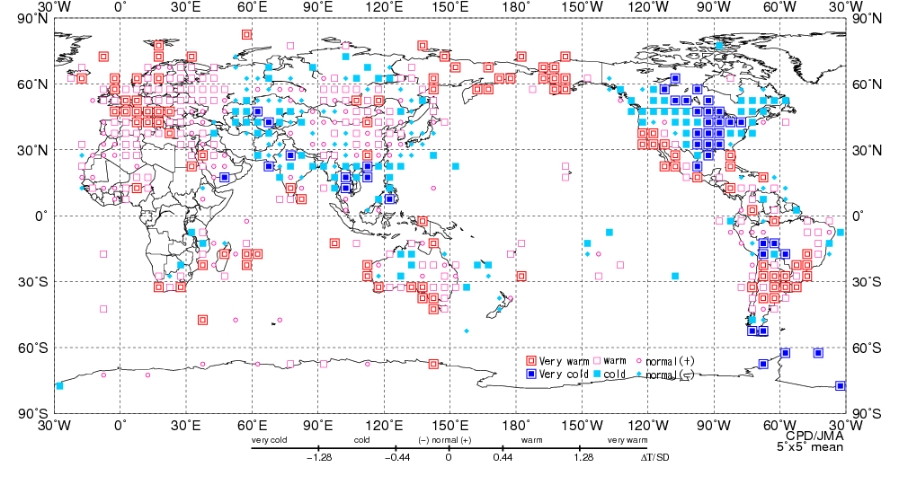
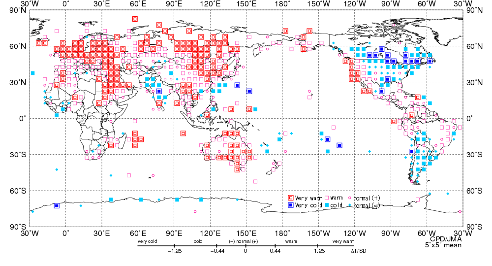
Good stuff, Rodney.
-
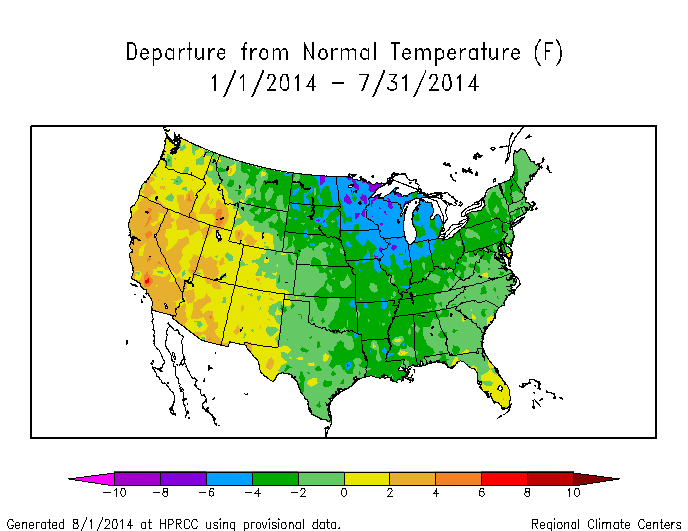
Thanks. Wow, those look like huge departures from normal. I would imagine anything over .5 to 1 degree either way is significant. One hell of a year.
Yeah, we've had this awesome persistent negative anomaly over most of the continuous 48. (Dec-Feb followed by Mar-May)
-
Great stats. Thanks! Has this departure from normal more or less replayed itself along the east coast?

-
The National Weather Service has upped DCA's snow accumulation for the March 16-17 storm from 6.7 to 7.7 inches, so now the IAD/DCA snowfall separation for 2013-14 is only 18.2 inches. So, for the moment at least, the 1992-93 snow season remains the kingpin for IAD/DCA snowfall separation, at 18.6 inches.
The double edited it, so DCA's total was 7.2"
-
Too bad Dulles record is so short. Everything there feels like a gimme.
Quite possible that both 1958 storms would have made that list.
-
Dulles' snowfall of 13.3 inches on February 12-13, 2014 cracked the IAD Top Ten, at #9, displacing to # 10 the December 25-26, 1969 snowfall of 12.1 inches.
Do you have the top-10 on hand, Rodney?
-
First time poster. Anyone know how January ranked for coldest overall in the lower 48 states as a whole? Or where I could find that info?
NOAA puts out a monthly climate report. It usually comes out about a week into the next month. http://www.ncdc.noaa.gov/sotc/
-
Thanks for your comment, but I think the question remains whether something has fundamentally changed in recent years. Consider that, during the first 112 years of DC temperature records, January 13th had a lower average daily temperature than January 21st 70 times (62.5%), with three ties (2.7%). However, during the most recent 31 years, January 13th had a lower average temperature than January 21st only five times (16.1%), with no ties. Think of this situation in a sports context: Suppose a baseball or hockey team had a winning percentage of .638 over its first 112 games (counting each of the three ties as half a win), and then plummeted to a winning percentage of only .161 over its most recent 31 games. Would you say that it's more likely that those sharply varying winning percentages can be explained by: (1) random fluctuations, or (2) a fundamental change in the team's performance?
Rodney, have you split it out before and after the move to the river location?
-
 1
1
-
-
Guess this is as good a place as any.. rehash of old news but most of our stories were temp/precip extremes in 2013:
Top 5 weather stories of the year around here
We were due for a lull after the run we had in the prior few years.
-
All-time monthly December high minimums set at IAD and BWI on the 22nd.
-
Don't worry. It'll be bumped again next year as we pine for some sort of appreciable snow for the third year running.
-
For First Time in 20 Years, Cold Records May Beat Warm
Hi max vs hi min is even more lopsided.
-
Somehow I've not seen this site before. It's pretty nice.
http://www.sercc.com/perspectives
Jason linked to it on CWG today.
Very cool. High temps season to date almost dead median with the 1930-present climate record.
-
nice article...I'd like to see CWG cover some aspects of the heat of the last 4 years without referencing AGW (not referring to the above article)....I don't know the answer, but it would be interesting to discuss the pattern driven and indice driven aspects of the big heat....MSP's top 8 max mins are all dust bowl.....9 of Denver's top 10 are dust bowl or 1880's....all of DC's are fairly recent...and of course the frequency too.....So if it isn't JUST UHI, why aren't places like MSP and DEN shattering their max min records?
MSP's records at the time were right downtown. It could be argued that the UHI was more acute in the 1930s than at the airport location now. Of course, since the dust bowl was partly anthropogenic, you wade into other territory...
-
Wettest June on record watch being issued for BWI.
14.02" at DCA just back in 2006, so probably out of reach there.
-
Assuming that we've seen the last of snow for this season, DC beat the old record snow minimum for two consecutive seasons by 3.1 inches, and IAD (at 8.6 inches this season and 3.7 inches last season) beat the old record (set four years ago) by 2.2 inches. There is nonetheless a big difference between DCA's and IAD's 2012-13 snow seasons: DCA's displaces last season's as the third lowest of 129 DC snow seasons, whereas IAD's is only the ninth lowest of 51 snow seasons there.

-
I can't remember exactly, but I think I had 28" in the first storm, and right about 10" in the second, so I'm sure I had over 30" in certain places, but the wind from the second storm really scoured out a lot of spots and ended up piling that snow in drifts and the like.
I had 24.7" in the first and 9" in the second, but with compaction and drifting it never really seemed like there was more snow around on Feb 10 than there was on Feb 6.
-
After the second storm on the 10th ended I took five measurements and had an average snowdepth of almost 55 inches.
That's where I get a little jealous. At no point did my yard have over 30", let alone 4'+.
-
You just made the big-time, with the DC snow drought featured on the Weather Channel. Of course, they managed to transpose a digit, claiming it's now 780 days, rather than 708. And they didn't credit your research, the way Ian did in his Capital Weather Gang story. But, if Al Roker picks up the story tomorrow morning, can fame and fortune be far behind?
That's funny. Honestly, I was just venting about not seeing snow and somebody in the thread asked about the snowless drought. I did the initial stat gathering, but Ian deserves most of the credit for the nice writeup and figures.
-
Our region's extreme run
in Mid Atlantic
Posted
We are going to put down some nasty departures as the norms go up in late Feb. Will be interesting to track.