

MN Transplant
-
Posts
16,375 -
Joined
-
Last visited
Content Type
Profiles
Blogs
Forums
American Weather
Media Demo
Store
Gallery
Posts posted by MN Transplant
-
-
Current three winter stretch is the snowiest on record for Dulles, VA (since 1963) at 122.7". Number two is 65-66 thru 67-68 with 105.5".
Snow town.
-
Think this is still king for me since I've been here. Rank:
Feb 5-6 2010
Jan 2016
Dec 2009
Yup, that's my list.
-
I think the totals in DC itself lean towards 2010. The reservoir was higher as was the spotter in Anacostia. No reports from near AU, but they were 25" and 27" in 2010, and I really doubt they were that high this time.agreed. I was fearing the dryslot for a few days, because the east solutions with an Apps dryslot didn't make any sense to me. It was pretty clear to me that Winchester/Martinsburg/Westminster would get smoked. I never once doubted that. And the 0z Euro Thursday night confirmed the dryslot fear. So I was prepared, but I just didn't think it would be for so long. It would have been cool to make a run at 25-30 for the city. But in the end we got raked with the Baltimore band. But I agree with you. In some ways we know too much.
I want to add that I am not a totals junkie. I know I am rarely going to do as well as the North and West folks, and I love snow whether it is 3" or 10". I wanted to witness the crippling of infrastructure. That was more my morning disappointment than anything. Not being able to see something unique in terms of downtown paralysis. In the end I saw it. Based on both the experience at the time and the post-mortem, I have no doubt in my mind that downtown DC experienced its biggest snow since 1922, and perhaps equal to 1899. This was undoubtedly bigger than 79/83/96/03/09/10 in my location. The 22" white house and 4th and L totals may be a tad inflated, but I think I cleared 20" easily. I also think DCA got at least 19 and maybe more.
-
I lean '10 over '16. The totals were basically equivalent, but the heavy snow and impact of 2010 outweigh the 2016 duration and wind for me.
-
This month yo

Nice. Wonder where we are on standard deviation. Dec is a monthly with a higher variation, but it is possible that this is still the most anomalous + month in DC history.
-
64 at DCA currently. Looking good to break the all time December min record tomorrow.
-
Super quick look at the records finds 75/60 on Jan 13, 1932 (+32 vs current norms, would be higher against the old numbers).
-
Today's 12z plug in for DC:
Euro: 51.9
GFS: 51.0
+11 to +12 month? lol.
I think I have Jan 1950 as the most anomalously positive month on record at DCA. +12.0 from the current norms. This could be a solid #2.
-
Also on track to finish in top 10 warmest years at DC.. tho not sure how we handle the sensor question on that one.
Probably about the same way we handle the fact that some of the old observations were taken multiple stories up in a building in a completely different part of town. Ignore it.
-
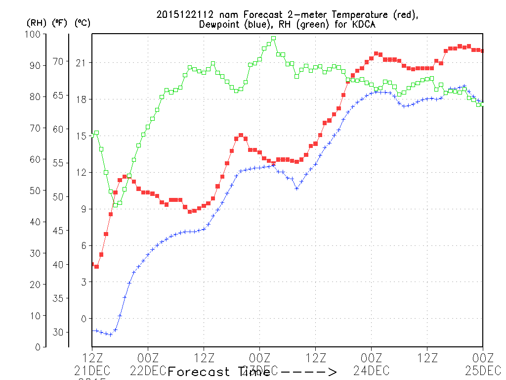
Was about to say NWS forecast is 63 now Christmas Eve morning. GFS suggests it's above that thru midnight.
Doesn't go out past 7pm, but this is a straight up obliteration from the NAM.

-
The highest minimum for any day in Dec at DCA is 59° on 12/5/1973. That record is in big trouble.
-
Per 12z GFS 12/19 plug in DC finishes 49.6 or 4 degrees above prior Dec record.
That would qualify as an obliteration. I wonder what the biggest gap between 1 and 2 is for any of the months.
-
The same is true for DCA (including historical DC records back to 1872) and IAD, with the NWS forecasts for Friday (November 6th) being 80 and 79, respectively, and the current records in each case being 78. However, the hurdle is not all that great, as the record high temperature from Nov. 6th until the end of the year is 83 for DCA and 81 for IAD. Both of those records were set on November 15, 1993.
80 would be a heck of a mark at any of the sites. Only a handful of 80s beyond the first few days of the month on record.
-
Wow. I'd love to see something like that. I imagine it was far worse in NE?
I don't know about NE, but Jan. 82 was about the peak of what winter can do in Minneapolis, with two 17"+ snowstorms in three days and a max snow depth of 38".
-
Nobody can convince me that a foot of ice wouldn't be awesome to experience.
We had a nasty ice storm in MN back in the mid-90s. Was supposed to be 12-18" of snow and the storm wrapped up too much and drove the warm air north. It was fun for a while, until we got a wet basement from the combo of ice clogged gutters and frozen ground. You don't want that at any time of year, let alone January.
-
I didn't realize IAD was so much lower. My house, DCA and BWI are all generally in the same 9" range. I'd like to see a monthly rainfall map of the region after the month is over.
I am at 7.25", but half of that is from the last week. IAD to my area to Manassas did not do well, as compared to other spots, in the first half of June.
-
BWI has 9.98" so that's the wettest June ever. Next milestone will be getting the double digit rain mark which is almost certain to happen. There's only 11 other months that ever reached the double digits (and none were in June):
Aug 1955 - 18.35
Aug 1933 - 13.83
Sept 2011 - 13.32
Sept 1934 - 12.41
Aug 1911 - 12.28
Sept 1999 - 11.5
Jul 1889 - 11.03
Aug 1971 - 10.91
Jul 1905 - 10.65
Sept 1876 - 10.52
Aug 2011 - 10.38
Fun to break a record. IAD is at 5.48" for more variability.
-
Four consecutive record max mins at DCA.
-
So, March is now winter and May is now summer. Yeah, Spring-pril.
-
looks like a lock, though didn't dig into the hundredths of a point. Still even if the 72.9 now is 72.85, today should push us to 73.1...what a vile month...
Yep. Hottest May on record. IAD will be at least top 3. Didn't check BWI.
-
Still a toss-up at DCA for warmest May on record.
-
Both MOS and the NWS forecasts leave DCA with the #2 warmest May on record. It wouldn't take much more to push to #1. Basically, an average of 88/71 the rest of the way is a tie.
-
I agree with your figures (I previously misstated this year's 1Q at IAD as 31.6 degrees). Bear in mind, though that these figures are unweighted averages of January, February, and March average monthly temperatures, which gives too much weight to February, as it has only 28 days (29 in leap years), compared to 31 days each in January and March. Weighting each of the first 90 days of each year equally results in 1Q 1970 being colder than 1Q 1978 at IAD (31.4 vs. 31.7). 2015 would still be third coldest, but at 32.0 degrees, rather than 31.8. Perhaps some day weighted averages will be used to calculate quarterly and seasonal averages.
Agree, I think we can give up a little simplicity for the sake of better accuracy.
-
BWI just crushed the record for coldest Jan-Mar period ever. Below are the top five:
2015: 31.9
1904: 32.3
1912: 32.5
1895: 32.6
1885: 32.6
I'm tempted to start saying "top 10 coldest year on record watch" again since we're way out in front, but I said that last year and had the rug pulled out from under me in December. Also there seems to be more chatter now about a flip to warm for the rest of spring and summer...
Rodney (or anyone) where did IAD rank? I had assumed it would be somewhere in the top five coldest?
Looks like 3rd at IAD
1970: 31.5
1978: 31.5
2015: 31.8
2014: 32.3
1969: 33.4
Coldest Feb/Mar combo on record though.
Our region's extreme run
in Mid Atlantic
Posted
No. Mar 2012 was a historic monster. Mar 2010, maybe.