StormySquares
-
Posts
71 -
Joined
-
Last visited
Content Type
Profiles
Blogs
Forums
American Weather
Media Demo
Store
Gallery
Everything posted by StormySquares
-
I found the location of the photo Andy posted. 41°18'14.9"N 94°27'11.7"W
-
Forgive me if I'm wrong, but didn't it look like the velocity signature weakened some as it went into Greenfield?
-
Severe Weather Threat 3/27/21 - NETX/LA/AR
StormySquares replied to cstrunk's topic in Central/Western States
VAD from Shreveport had around 300 0-3km SRH -
Severe Weather Threat 3/27/21 - NETX/LA/AR
StormySquares replied to cstrunk's topic in Central/Western States
Sig tor on going southeast of Carthage, TX
-
I think the 12z HRRR redefined what the ceiling may be
-
I agree. It doesn't feel right that last Wednesday had the same probs as 4/27 or 5/24. This Thursday looks pretty impressive.
-
For what it's worth a 45% did verify in Alabama. A large high risk area verified for much of central Alabama and eastern Mississippi.
-
March 17-18 Severe Weather Event
StormySquares replied to DanLarsen34's topic in Southeastern States
Possible SVC feeding into the Selma storm enhancing tornado potential. -
March 17-18 Severe Weather Event
StormySquares replied to DanLarsen34's topic in Southeastern States
The cells coming into Alabama be I-20 could cause some problems in the next few hours. -
March 17-18 Severe Weather Event
StormySquares replied to DanLarsen34's topic in Southeastern States
New PDS watch up. 80/80 props -
March 17-18 Severe Weather Event
StormySquares replied to DanLarsen34's topic in Southeastern States
Not with the pacific front still back in Texas. It's only 22:30z. Up until this morning the main tornado threat wasn't until after 00z. -
March 17-18 Severe Weather Event
StormySquares replied to DanLarsen34's topic in Southeastern States
The TOG on the Brookewood storm is literally on the 4/27 path. -
March 17-18 Severe Weather Event
StormySquares replied to DanLarsen34's topic in Southeastern States
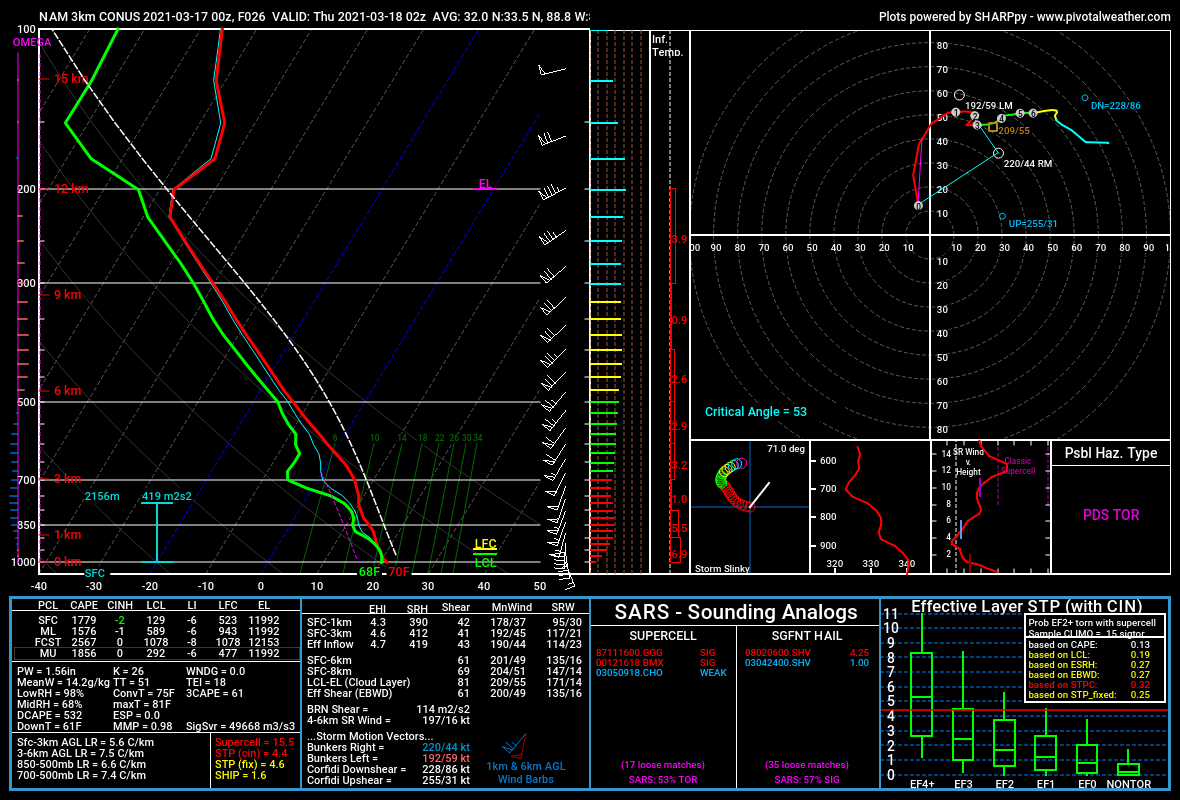
Area average sounding from the 3kNAM at 02z. Downright scary.
-
March 17-18 Severe Weather Event
StormySquares replied to DanLarsen34's topic in Southeastern States
Spann has done a pretty good job of saying the primary threat for Alabama may not be until overnight. -
I'm setting up in east Iowa, probably use US 11 to get back across the Mississippi. Hopefully any sups track north of my house (Janesville). Today is conditional but I'm thinking it over preforms, especially if SPC leaves it at slight.
-
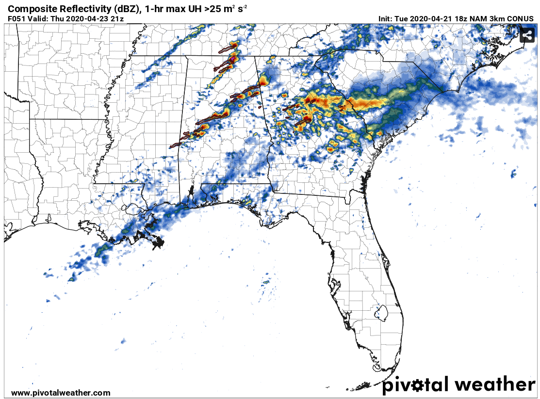
NAM3K doesn't have discrete cells often, but it does Thursday. Most models are showing the slowing trend, Thursday looks to be another severe weather outbreak across Dixie. Pending 00z guidance a day 2 moderate risk is certainly possible.

-
Really the only model that isn't on board is the GFS, UKMet has been mirroring the NAM for the past couple days.
-
Is it me or is the 12z Euro almost a copy of the past few NAM runs at 500mb.
-
12z Euro continues to slow a bit.
-
The outflow from the northern convection earlier is coming south. If the storm rides it, the tornado threat may continue, but the stable air may cut off surface inflow.
-
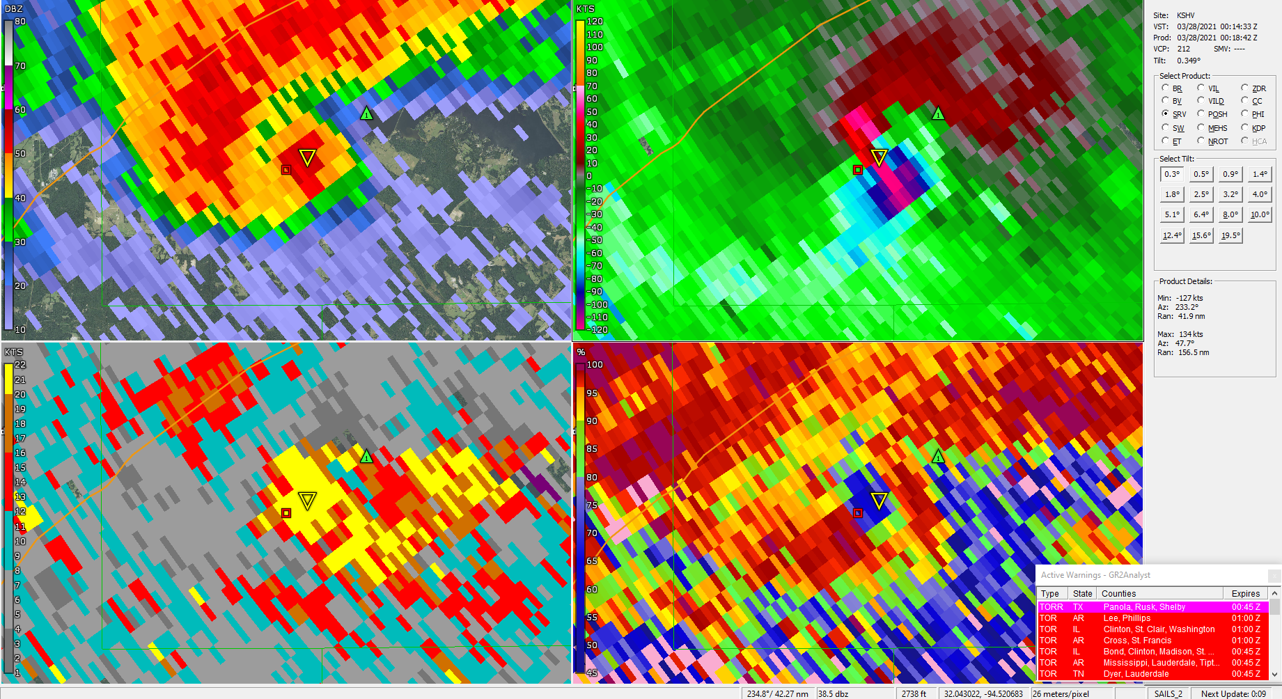
Plenty of trees in MS. The terrain it's going over isn't any different then when the cc hole was very deep.
-
What would cause the velocity to be this impressive but have the cc hole progressively get less pronounced? Can someone smarter then me answer this?
-
Looks like the storm behind it may be raining into the updraft, I wonder what that's going to do to the longevity of the tornado.
-
There's the cc drop. GR2 seems to be having a problem resolving the velocity again. Strong couplet though.