

stormdragonwx
-
Posts
463 -
Joined
-
Last visited
Content Type
Profiles
Blogs
Forums
American Weather
Media Demo
Store
Gallery
Posts posted by stormdragonwx
-
-
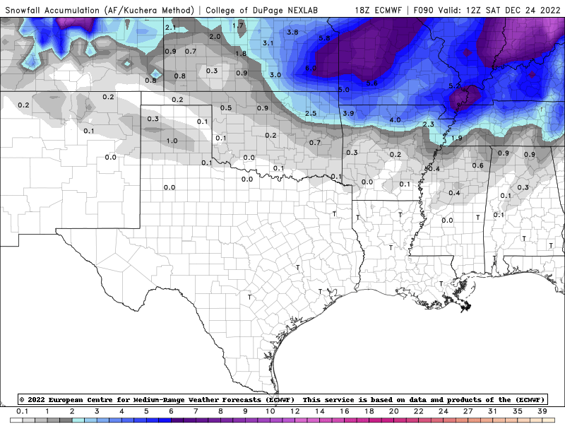
Man, who killed the forum? lol Here is the 18z Euro.
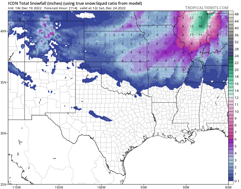
And the 00z ICON
-
 1
1
-
-
29 minutes ago, MUWX said:
Springfield extended their winter storm watch. It now includes basically everyone except the southern tier of counties.
Make sense for them. I figured SGF would either today or tomorrow. You guys up there will have a lot more going on.
Meanwhile TSA is continuing to dial back on the snow impacts and focusing on the wind chills.
-
Oh I am sure it will. It will be interesting to see nonetheless.
-
Looks like models are trending drier and further north again. As it sits I think outside of MO and KS we will see 1" maybe 2" at best. HRRR and 3km NAM are coming into range and seem to indicate the same.
-
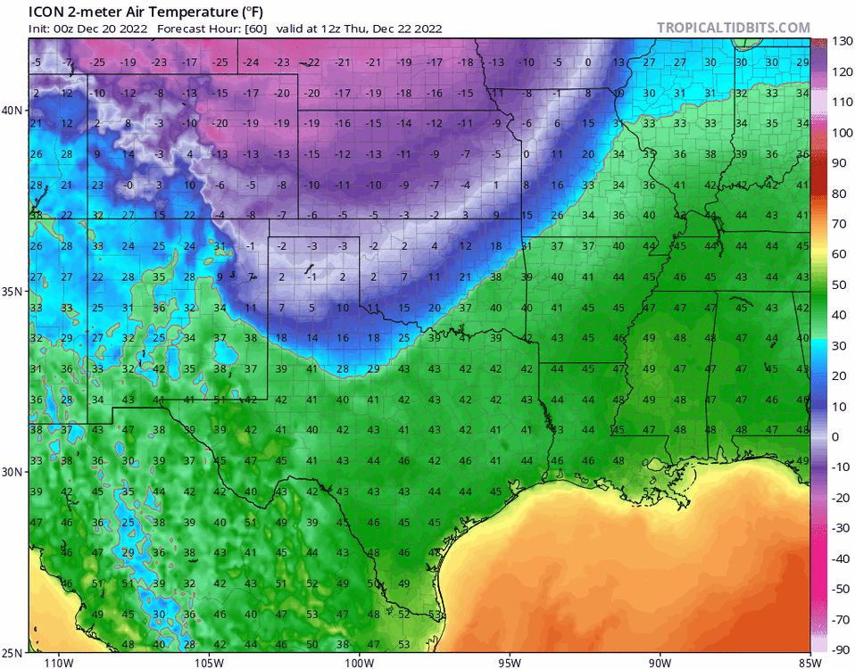
And here's the 2m Temps during the day Thurs. Impressive.
-
33 minutes ago, rockchalk83 said:
The Icon has the right idea. Cold air is dense and always moves faster than forecast.
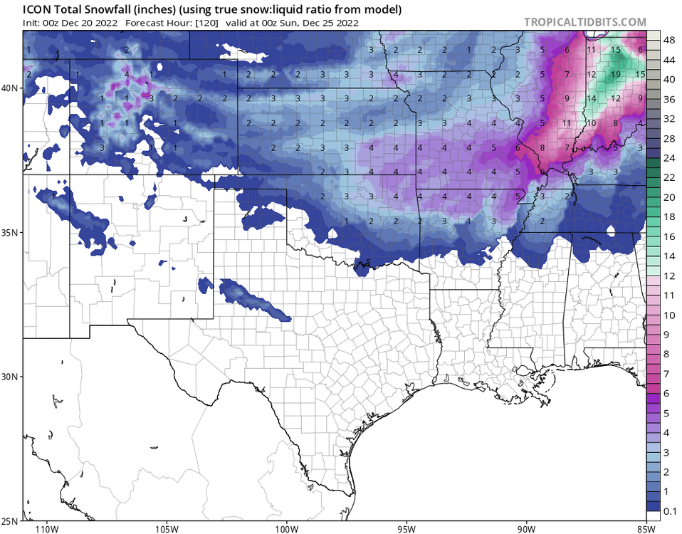
Yeah here is the output data from that model. Its being more generous with the snow totals as well.
-
1
-
-
I will be very curious to see what kind of ratios we will see if we do get temps in the single digits for highs as some of the data indicated.
-
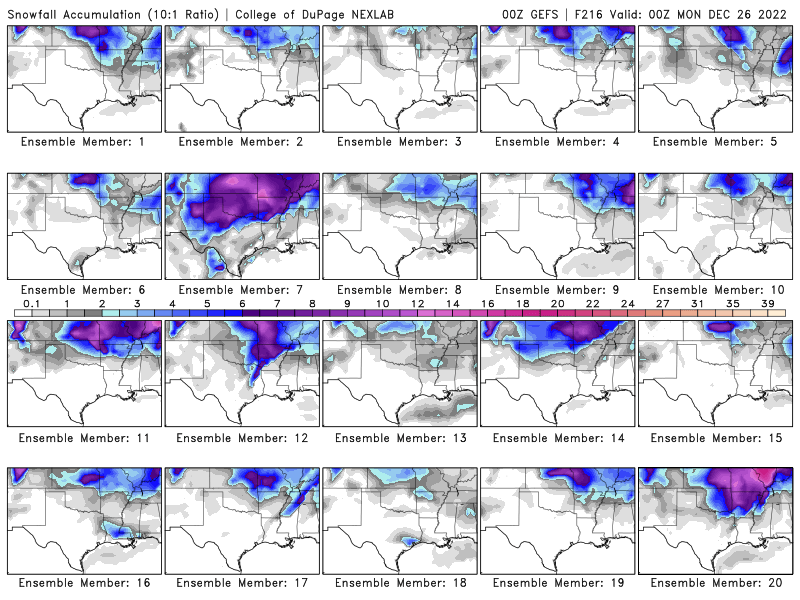
I expected as much. GFS Ensembles are still pulling away on the snow chances and keeping it back up north. Bye Bye White Christmas if this holds. Better hope the Euro/Canadian and short range models don't follow in the next day or so. Instead of HWY 412 being the cut-off line this may be a HWY 60 event, if that.
-
Heh yeah it almost seems like the 00z GFS Ensembles heard my earlier comment about the HWY 412 cut-off line. Definitely shifted north on a lot of these.
-
I was gonna say... I'd be happy with the Canadian. Gotta remember with the extreme cold the ratios will be greater than 10:1.

-
IDK I have a feeling this is one of those setups where theres gonna be a sharp cut-off south of the 412 line while areas north will get absolutely dumped on. At least with what the data trends indicate.
Impressive Ensemble agreement though. Someone here is getting dumped on soon.
-
When the NAM, Short Range Canadian (RDPS), and HRRR don't hop on in the next couple days, that's when I will get concerned.
-
Oh boy. I was just made aware of this. Not sure what else to say here. This is the same guy that sparked the "drive south" memes.
-
 1
1
-
 1
1
-
-
2 hours ago, Wx 24/7 said:
I have been Charlie Browned too many times... I will wait until the snow is on radar before I get too excited.
I feel ya on that. Expecting it to all be gone by Tuesdays runs when the hi-res NAM and HRRR get hold of it. lol
-
38 minutes ago, StormChazer said:
Until the Euro hops on, I remain uneasy.
This 100%, while they can still be faulty, I am paying more close attention to Ensembles for this reason.
-
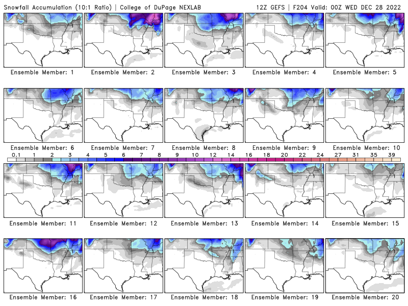
Oh and the Ensembles continue to trend up with more members getting snowier.
From the 12z GEFS: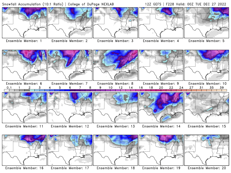
-
1
-
-
With as much snow pack as these models are spitting out in some instances, it could tank the temps even more.
-
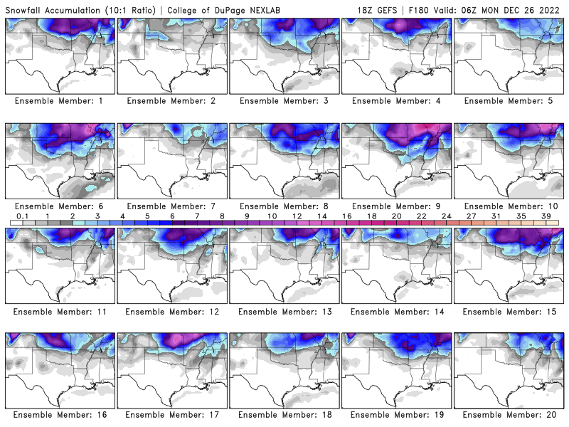
3 hours ago, The Waterboy said:
00z GFS looks like an unorganized hot mess.
But man look how many Ensembles dump on the 4 state area.
Another thing to note too that hasn't really been covered is with the temps being as cold as some of these models are forecasting, the 10:1 ratio on the models might not be the best way to gauge how much snow will actually fall. If we are looking at teens and single digits, this may be a 20-25:1 ratio with overall amounts still depending on the timing/track of any system that comes thru with sufficient moisture to work with. The latter will be key to all this.
-
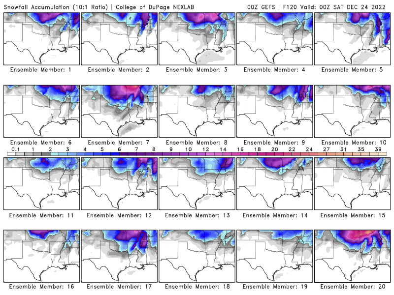
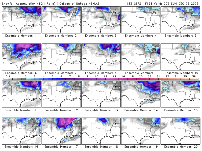
Lol that 18z GFS is too good to be true. That would blow the '09 event out of the water if so.
Though here is the Ensemble from the 18z GFS.
-
6 hours ago, Ozarkwx said:
Stormdragonwx - When I click on the first link it takes me to what looks like the home page. Not sure where to go from there. Can you describe how to get to (or directly link) to the page to that displays the ensemble snow map. Thx.
On the website I linked I will note it's just the GFS Ensembles. It's the 2nd tab from the right labeled GEFS. Your options for which GEFS data to view are on the left then just run the slider on the bottom to view the forecast hours. Hope that helps.
-
For simplicity and ease of access, you have this one here to play around with on the COD page. https://weather.cod.edu/forecast/
Previous Run Comparison: https://climate.cod.edu/hanis/model/prun/?type=2022121506-GEFS-SGP-winter-snens-258
-
 1
1
-
-
Pretty good discussion here: https://twitter.com/weatherdan/status/1603212360826617856?s=20&t=mOWWzMh
CONUS Euro Ensemble Probs: https://twitter.com/weatherdan/status/1603212396356591617/photo/1
-
2 hours ago, StormChazer said:
Could you imagine this 6AM Christmas morning? Of course, that requires getting 2 feet of snow, but I digress.

That's close to Feb 2011 cold!
-
1 hour ago, NWAflizzard said:
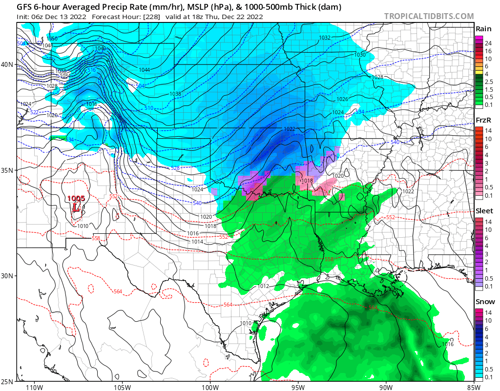
I know I was hating on the GFS mere days ago but I will definitely take what the 06z is serving up at 228 hours. This would be a win for the entire forum. The cold air it brings in behind this would mean a white Christmas.
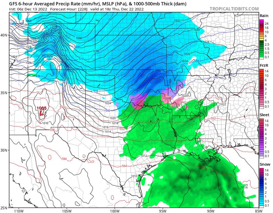
Indeed both the GFS and Euro last night on the 0Z runs were on board with a snowy scenario.


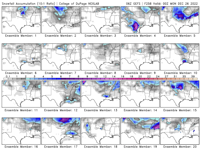
EDIT: Just saw the 06z run on the GFS, nearly two feet for parts of OK/KS. Yeah right. lol

MO/KS/AR/OK 2022-2023 Winter Discussion
in Central/Western States
Posted
Yeah I think south of 412 will be lucky to see an inch 2" tops. IMO