
stormdragonwx
-
Posts
411 -
Joined
-
Last visited
Content Type
Profiles
Blogs
Forums
American Weather
Media Demo
Store
Gallery
Posts posted by stormdragonwx
-
-
Textbook CC drop now being recorded. Obvious direct hit taken to Rolling Fork, MS.
-
Yup chasers are scoring big in western MS right now. (excuse the pun) https://twitter.com/Tornado_Warned/status/1639432371169804289/photo/1
Another: https://twitter.com/WxZachary/status/1639433366725328897?s=20
-
Prospects so far don't look great for discrete supercells down there. HRRR looks messy again too. That linear convective mess is getting close to overtaking the risk area. Something better start popping out ahead in the next hour or two. Otherwise this may just be a QLCS event with a bunch of spinups vs. violent long track supercell tors thru the evening. Granted this is good news for the general public that live there, if so.
-
 1
1
-
-
Couldn't help but notice in later outlooks SPC changed the wording from "Tornado Outbreak" to "Severe Weather Outbreak".
-
Despite the incoming cold snap it looks like our last hurrah for winter storms seems to be going out with a wimper instead. I had some hope on the GFS/Euro mid-month for my area but its looking less likely now it seems.
-
My target area looks to be verifying. I would have picked this spot if I chased down there today.
-
2 hours ago, Ed, snow and hurricane fan said:
SWODY Day 1 enahnced, with 10% sig tornadoes and hail, in S Arkansas and a small bit of neighboring TN and MS
I suspected as much. The day before the day could be interesting.
-
1
-
-
Indeed I'm thinking tomorrow might be a decent day before the day type setup. HRRR has been consistent on tracking a lone supercell over southern AR.
-
Insane storm motions.
-
1
-
-
Yeah I get its all part of the early season hype and everyone is antsy to get out on the roads again but I wouldn't be quick to bite on this.
Its only February.

-
1
-
-
Clock is ticking. Beginning to wonder if the Jan 24th system is gonna be our only major widespread snow storm for the southern plains this year. And of course for many that was a bust too.
-
NVM models pulled a complete Lucy this afternoon.
-
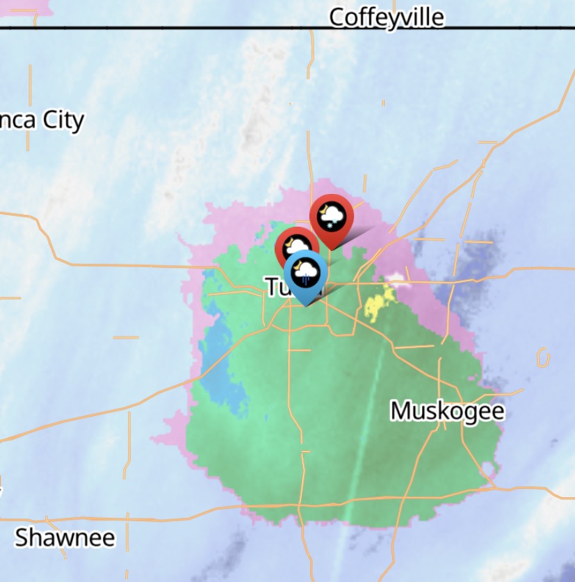
Well they already recorded 2-3" of snow just west of the OKC metro tonight. Will be interesting to see how this progresses tonight and later this week.
-
1
-
-
Some models vary but the end of the week might get interesting for some of us. Thoughts?
-
16 minutes ago, ouamber said:
It's actually hilarious at this point! I'm actually cheering on the donut hole!
 How long can Tulsa go snowless! Just incredible at how bad this BUST was!
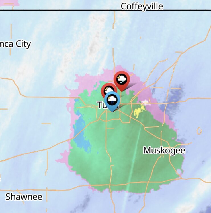
Just... eww. That really sucks.
-
 1
1
-
-
Could be true. It will be interesting to see how much of that wraparound holds together or intensifies as well. The latter could also decide things for SW MO and NE OK.
-
There's talk of a dreaded Dry Slot now... that could kill our overall totals here in AR too. Storm was too good to be true. https://twitter.com/NWSLittleRock/status/1618057323569713153?s=20
-
Was driving around. Been parked up here by Drake Field/Greenland with 1.5-2 in of accumulation already. Its covering parking lots and the main streets now with the latter being a slushy mess but still covered. Large heavy snowflakes continue to fall.
-
Indeed I was surprised how quick it changed over and accumulated since my last post. And yes it's sticking to both grassy surfaces and surprisingly even to parking lots and lesser driven streets. Dropped rapidly to 34 at my location over the past hour. Large wet heavy flakes falling.
-
Yeah higher elevations might still get the forecast 6-12" over my way but I think where I am at Im probably gonna be seeing 4-6" max if this doesn't shift SE as some models are wanting to hint at otherwise. Lower 40's temps is not a good sign.
-
Hoping the temps start to crash soon here in NWA or the forecast might get blown. Currently 42 here at my place.
-
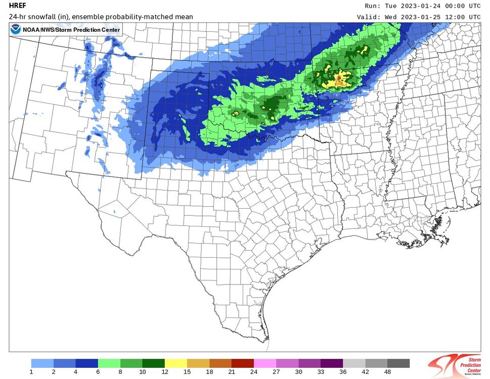
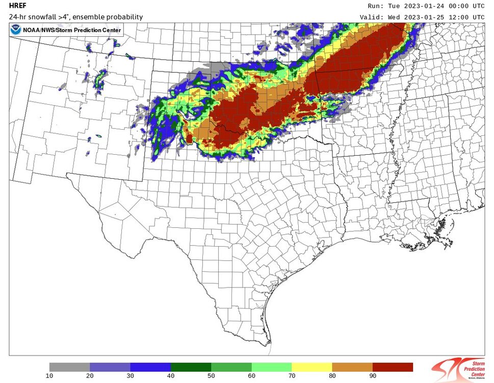
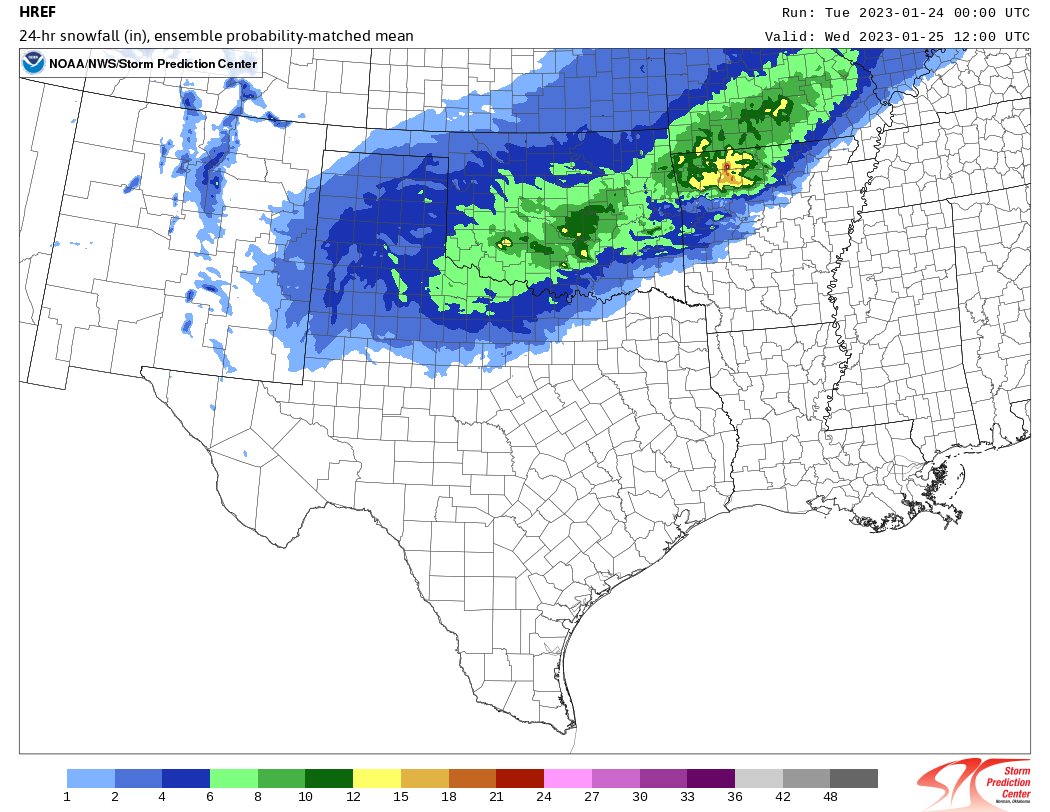
Fun times ahead. Figured its time to break out the HREF data. Its been awhile.
Also worth noting, the 8"+ parameter probs are lit up too. https://www.spc.noaa.gov/exper/href/?model=href&product=snowfall_024h_prob_series§or=sp&postage_stamp=true
-
10 minutes ago, MoWeatherguy said:
NAM is still amped tonight. Would love to see temps start to model colder.
That's the one thing the TV Mets are going on about down here right now, they aren't buying the 10:1 ratios and staying conservative on the totals thinking the 32-34 degree temps could make the ratios closer to 7:1 which makes sense as the snow would be wetter and cause compaction. Its noteworthy TSA and SGF are sticking to the 10:1 data though. It will be interesting to see who winds up being right and if this storm system does go colder.
-
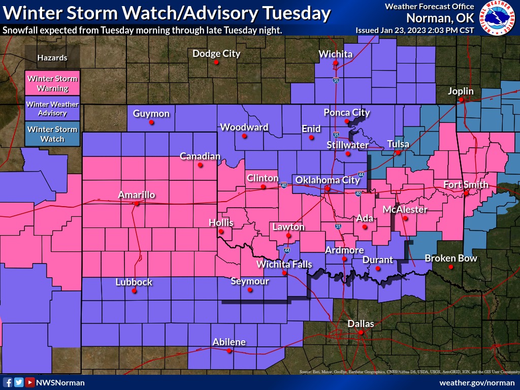
Winter Storm Warning just issued. Extends all the way out into New Mexico.
Edit: Ninja'd by NWAflizzard lol

-
1
-


Severe Weather 3-23-23 through 3-26-23
in Central/Western States
Posted
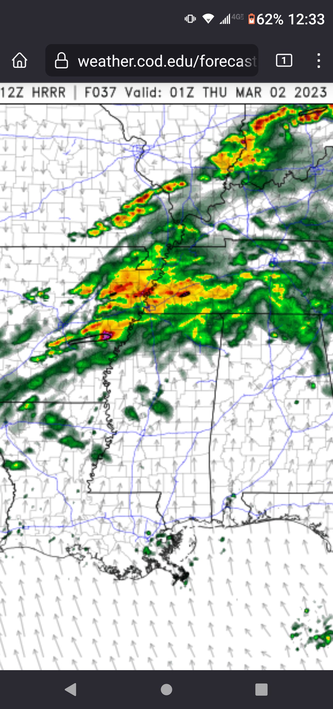
Dire messages coming from chasers on Twitter. https://twitter.com/DFWStormChasing/status/1639437281755791360?s=20
EDIT: Images coming in now.
Photo Credit: Zachary Hall