

stormdragonwx
-
Posts
416 -
Joined
-
Last visited
Content Type
Profiles
Blogs
Forums
American Weather
Media Demo
Store
Gallery
Posts posted by stormdragonwx
-
-
Yeah I was really looking forward to a potential chase in my favorite area tomorrow but that hope is fading as im not sure I wanna drive 8 hours just to run from a squall line. Latest data all showing pretty quick upscale growth. Maybe late May or June will throw us a bone.
-
Well.. that was disappointing. Yeah I chased that same NE OK cell down to Pineville, MO before I called it quits. I really thought it was gonna produce at one point as it neared Seneca on the state line. Typical 2020 junk storms as usual around here. I think if the storms took more of a E/NE track it could have helped them produce. Never been a fan of S/SE storm motions.
-
 1
1
-
-
I think I will be sticking to my Miami to Joplin target area where there is clearing.
-
Yes it could be interesting tomorrow. My Target Triangle of interest is between Purcell, Madill, and McAlester, OK. Could be some nasty storms in this area as we go into the evening.
-
Unless something springs up towards the beginning of March, I think this season is done.
-
25 minutes ago, MUWX said:
I guess we didn’t learn our lesson this week, so Mother Nature is going to show us again this coming week
Yup, believe it when I see it.
-
1
-
-
Yeah looking pretty disappointing so far. 33 and rain as usual here in the Fayetteville area as well.
-
1
-
-
34 minutes ago, MUWX said:
Tulsa went WWA for NWA
Yup as I suspected probably gonna be 33 and rain again for the Fayetteville area. We will see. Stranger things have happened.
-
1
-
-
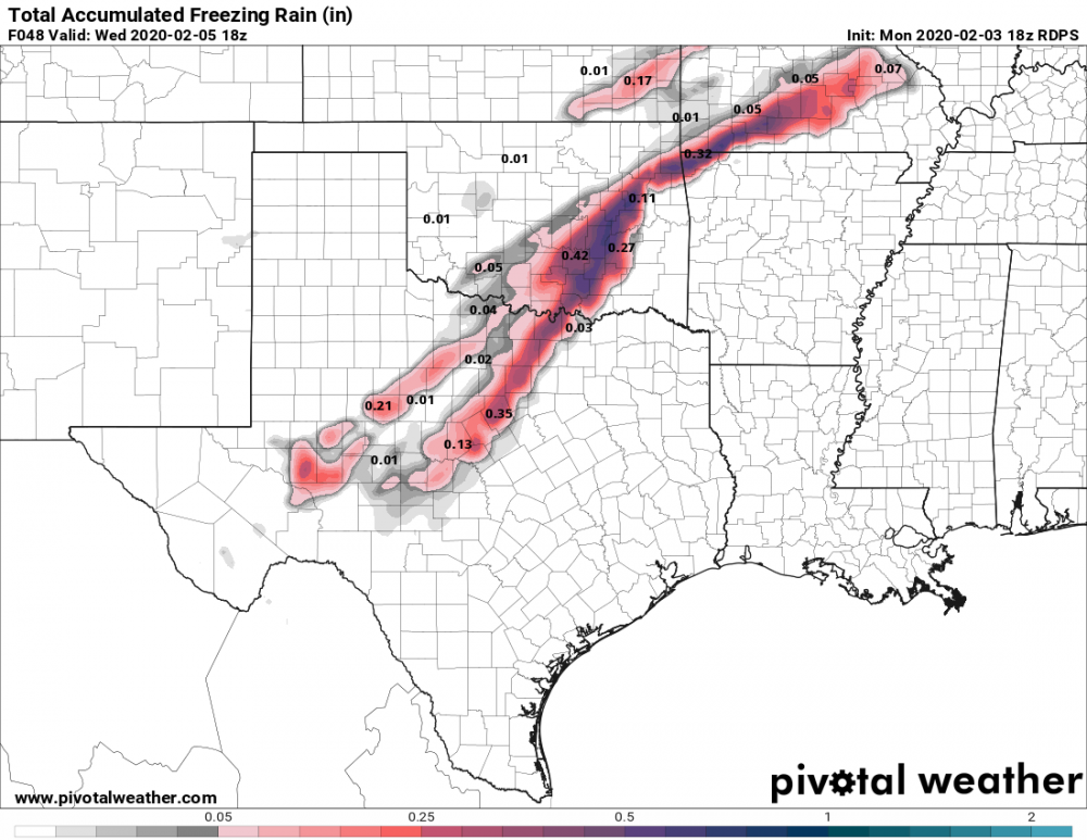
Something that has been getting overlooked is concern for icing. SE OK, NW AR, and Southern MO is notorious for getting Ice storms with systems like this due to the terrain as the cold air needs more time to filter into the area thru all the levels. With it being as warm as it has been over the past few days I have my doubts if the cold air will fully arrive in time for any snow SE of I-44. Right now its mostly been the Canadian models showing it but the NAM and GFS have hinted a bit more on it too.
Though if I am realistic it will probably be 33 degrees and rain as it has been all season in my area. I will take that over ice.
-
1411 Tornadoes
First High Risk: May 5th

Severe Weather May 13-15th, 2020
in Central/Western States
Posted
Currently positioning near Garnett, KS, looks to be a decent area. Today doesn't look outstanding but HRRR does consistently show an isolated storm tracking thru there.