

stormdragonwx
-
Posts
411 -
Joined
-
Last visited
Content Type
Profiles
Blogs
Forums
American Weather
Media Demo
Store
Gallery
Posts posted by stormdragonwx
-
-
Lol incredible. Fayetteville getting the stiff again.
-
 1
1
-
-
Must be having some dry air aloft. Radar showing a lot of snow over me but it's not coming down anymore.

-
Reporting snow here in SE Fayetteville too.
-
 1
1
-
-
2 hours ago, The Waterboy said:
I’ve held out hope until now but looks like it’s time to tap out for those of us in NW AR. Not happening this time. Hopefully you guys north and west cash in.
Yup typical 33 and rain again.
-
 3
3
-
-
25 minutes ago, The Waterboy said:
You and I get hammered on that Canadian run. The 2009 storm (was 2000 a typo?) was awful. Lots of damage.
I was actually living in Tulsa for the 2009 one. I agree with what you said from what I saw and heard. The 2000 one that hit on Christmas Eve was pretty rough too.
-
 1
1
-
-
Yeah I got a bad feeling this is gonna become a nasty Ice Storm for my neck of the woods. I remember the one in 2000 that hit around this time of the year.
-
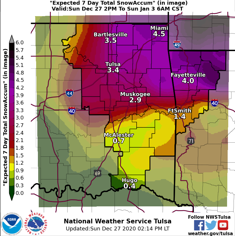
Still 4 days out and while I have observed TSA is usually pretty cautious and conservative, they already pulled the trigger upping the amounts on the DSP graphic.
Personally, I hope this doesn't morph into a crippling ice storm like what some of the models were hinting at.

-
1
-
-
Currently at work here in the Springdale, AR area. Approaching 2" now after finally changing over around 12pm.
-
1
-
-
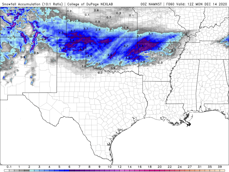
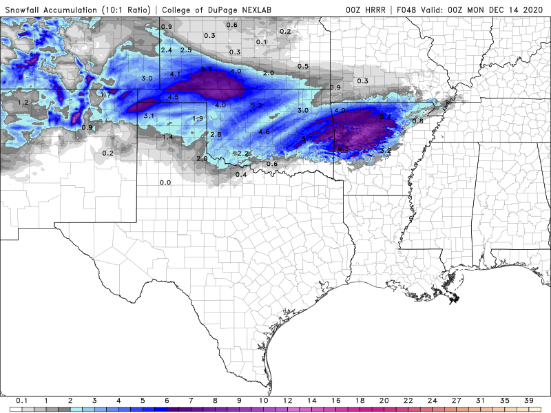
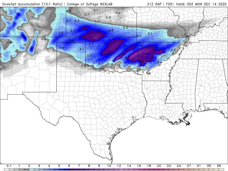
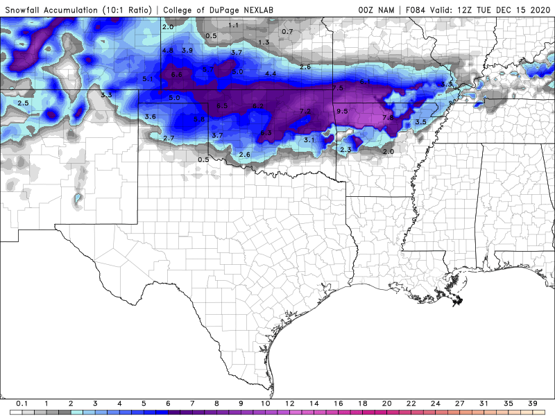
Yeah Dan Skoff at KNWA is saying 8" in NW AR and that it might actually be conservative. All the models are showing at least 6" or more now too. That doesn't happen too often.
-
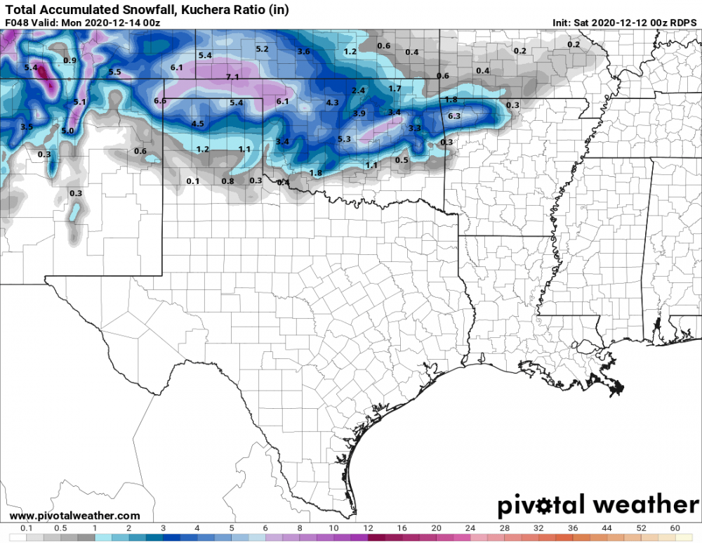
As I mentioned in my other post I think the best way to determine the precip accumulations taking into account for melting will be to take the 10:1 parameter and half it. The Kuchera Ratio also looks somewhat accurate to getting the real totals.
Also regarding the thundersnow potential, I also do recall an event similar to this back on March 28th, 2009. I was living in Tulsa and we had a thundersnow event that day. It was just above freezing and had heavy wet flakes as a result. Got 9" in a few hours that melted to about 5" at sundown.
-
1
-
-
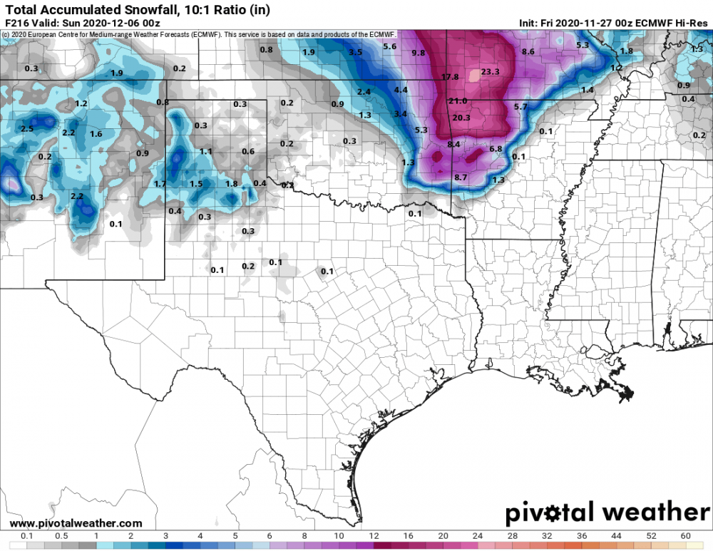
NAM, NAM 3k, RAP, HRRR and even the Canadian are saying its happening and upping totals/coverage overall. Might even be getting some convective thundersnow out of this. Temps are also trending colder. Though to be realistic I do think some of these totals seen here are overdoing it. Might cut the totals in half to get our real amounts due to the warm ground temps causing melting and compacting.
EDIT: When you go back in and look at the Kuchera Ratio I think those will be closer to our actual amounts.
-
1
-
-
00z GFS and Euro looking interesting. TV Meteorologists also taking note of it on their social media posts.
-
12 hours ago, JoMo said:
The 00z Euro was a beauty. Too bad it's not 24 hours out so it won't happen, heh
LOL yeah...
-
After going on nearly 6 lackluster winters in a row, I am learning not to get my hopes up for an eventful winter around here. lol
-
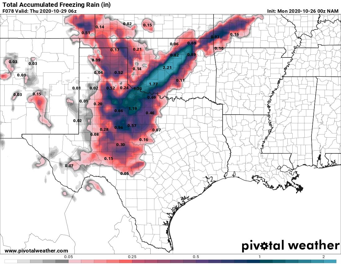
Looks like the NAM pretty much nailed it. Just NW of OKC they have just shy of 2" of ice accumulation! Unbelievable... https://www.facebook.com/colt.forney/posts/10164673026050227
-
I joked a few days ago about a crippling Ice Storm because ya know... 2020 but now the 0z NAM has come into range with 2+ inches of ice. This along with leaves still being on most trees would be pretty devastating. I do think its being bullish jumping on board with that kind of outcome even though the GFS has been showing some kind of Ice Storm for several days now. Something will happen but 2+ inches of ice seems farfetched.

-
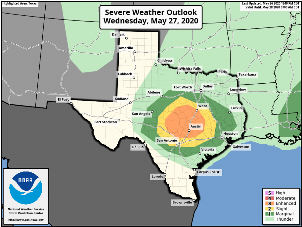
I know its outside of the range for this discussion thread but does anyone have thoughts on the TX setup for tomorrow? Trying to make the most of this lackluster season and since I am off work till Friday I'm considering taking a shot at it even if it is a 12 hour drive one way. Though the pattern looks to be about the same as its been this year with messy HP storm modes and SSE storm motions from my initial look at the models. Either way I'm surprised there hasn't been more talk on this setup.
-
Been debating on making the 8 hour drive out to the panhandle area myself tomorrow even though its on the marginal end of the slight risk spectrum. Gotta take what we can get though. This May has been pretty disappointing overall as others have mentioned.
-
Neat little meso wake low thing happened today in and around NW Arkansas. Had 50mph winds at one point knocking down trees throughout the area in spots.
-
Currently positioning near Garnett, KS, looks to be a decent area. Today doesn't look outstanding but HRRR does consistently show an isolated storm tracking thru there.
-
Yeah I was really looking forward to a potential chase in my favorite area tomorrow but that hope is fading as im not sure I wanna drive 8 hours just to run from a squall line. Latest data all showing pretty quick upscale growth. Maybe late May or June will throw us a bone.
-
Well.. that was disappointing. Yeah I chased that same NE OK cell down to Pineville, MO before I called it quits. I really thought it was gonna produce at one point as it neared Seneca on the state line. Typical 2020 junk storms as usual around here. I think if the storms took more of a E/NE track it could have helped them produce. Never been a fan of S/SE storm motions.
-
1
-
-
I think I will be sticking to my Miami to Joplin target area where there is clearing.
-
Yes it could be interesting tomorrow. My Target Triangle of interest is between Purcell, Madill, and McAlester, OK. Could be some nasty storms in this area as we go into the evening.


MO/KS/AR/OK 2020-2021 "Winter" Discussion
in Central/Western States
Posted
Liking these trends for my area being less than 48 hours out.
18z GFS (v16), 12z Euro, 12z WRF, and finally the 18z NAM 3km
Waiting for the 00z models to finish up their runs. I bet the WSW gets extended north and west a bit.