

Snownado
-
Posts
440 -
Joined
-
Last visited
Content Type
Profiles
Blogs
Forums
American Weather
Media Demo
Store
Gallery
Posts posted by Snownado
-
-
17 minutes ago, FamouslyHot said:
Eh we have plenty of 2 week periods that look bad for snow, at least this one has some promise on the horizon. I know there's often a metaphorical carrot dangling in front of us with the projected pattern, but I can't help but get excited because this is a BIG carrot. SSW event with a -NAO, +PNA and no southeast ridge is a blockbuster pattern.
A blockbuster pattern for many, maybe. For Columbia ? Probably not.
-
 1
1
-
-
Will there be any snow on the ground in Indy on Christmas morning ? I don't care if it's just a dusting. I want a White Christmas.
-
 1
1
-
-
Does the midwest ever get 40" of snow in a single storm like the Northeast does at times outside of the lake effect snow ?
-
How long before vaccines start having an impact on covid deaths ?
-
TWC is showing estimated snowfall of 3-5" for most of the Indy area but I only measured 2" in Carmel. They also show 5-8" for some areas NW of Indy.
-
Shouldn't we all be rooting for a warm winter ? Wouldn't a warm winter help reduce the spread of Covid since more people would be outdoors enjoying the warmth ?
-
1
-
 1
1
-
 2
2
-
-
1 minute ago, michsnowfreak said:
I like gray skies in winter but it's irritating when snow melts, then it turns gray. The absolute perfect Winter scene is a steel gray sky with fresh bright white snow everywhere.
I prefer a bright blue sky with snow on the ground.
-
I swear the Northeast has more interesting weather than the Midwest.
-
1
-
-
1 minute ago, michsnowfreak said:
After a 4 inch snowfall started the month we had nothing but sunshine...now that the snow finished melting yesterday, its gray.

Bare ground and gray skies can be depressing.
-
1
-
-
Honestly you should be thankful Chicago gets as much snow and cold as they do considering they are not very far north. Chicago is closer to the equator than the North Pole. I imagine most cities close to Chicago's latitude across the world are warmer and less snowy.
-
4
-
-
2 hours ago, bowtie` said:
Oddities of oddities, the earliest sunset is around Dec. 07 here at KIND. Yeah the sunrises are still compressing but at least we will stop the bleeding here in less-than-a-handful of days in the back-half.
at least you are not over the border in Illinois where the sun sets at around 4:25. Or if you were in Gary, IN the sunset would be 4:19. Sun sets in Indy around 5:20
-
1
-
-
9 minutes ago, Hoosier said:
Yesterday was adjusted upward on worldometers to 206k cases and 2,875 deaths.
There were about 2,977 people killed in the 9/11 attacks.
I never understood why people compare this to 9/11. Two totally different circumstances.
-
1
-
2
-
-
6 minutes ago, Snowstorms said:
Without diving into too much detail, both the GEFS and EPS offer some hope after Dec 10th. The current +PNA retrogrades into the EPO region and that offers up our first legitimate cold shot of the season ~Dec 12-14. Would likely feature a rainer around that time frame before things settle into a wintrier pattern thereafter. Eventually due to the background Nina forcing, the ridge makes its way towards the Aleutians/AK which cools most of Canada down as the PV sits overtop. In other words, the current Nino like pattern eventually gives way to a more typical Nina like December around mid-month. There is also increasing chances for Arctic blocking around mid-December as well. I’d say our first winter storm will be ~Dec 15 to Dec 20.
Havent you already had a winter storm ?
-
3 minutes ago, Snowstorms said:
Some Nov stats at YYZ. Records at YYZ only go back to 1937.
Snowfall: 9.2" - average is 3.0". Snowiest Nov since Nov 2002. Featured biggest single day snowstorm in 70 years
Mean temp: 44.2F - average is 38.6F. 2nd warmest Nov on record behind 2001.
What a crazy month.
How is it even possible to have the 2nd warmest November on record and also have the snowiest November since 2002 ?
-
2
-
-
Is it just me or do the clouds always seem to linger longer than predicted this time of year ?
-
Talk about a screw job for Fort Wayne.

-
1
-
-
4 minutes ago, snowlover2 said:
The problem is that temps are going to be above freezing until monday night so snow will have a real hard time accumulating until then.
At least the sun angle is low so that shouldn't be an issue !
-
1 minute ago, Gino27 said:

They just updated it to include the rest of Tuesday. This is either conservative, or genius. Time will tell.
Is this consistent with most of the models ? It seems to me like most models are showing a bit more than this ?
-
1 minute ago, Gino27 said:
ILN is also forecasting this as a two round system. There would still be a few more inches across the board after 4am.
That's kind of deceiving then. Why not just issue a forecast for the entire 2 rounds instead of just for 1 round ?
-
Just now, Angrysummons said:
People shouldn't put too much hype into this system. It will struggle to accum outside elevated areas. It really needed a powerful phase to generate the kind of storm weenies hope for.
Its sorta a premeal snack.
Not everyone needs 10" to be happy. I grew up in the south and 2" is a lot of snow by my standards.
-
3
-
-
7 minutes ago, jrips27 said:
Thanks for the help guys. Looking to reserve a room this evening.
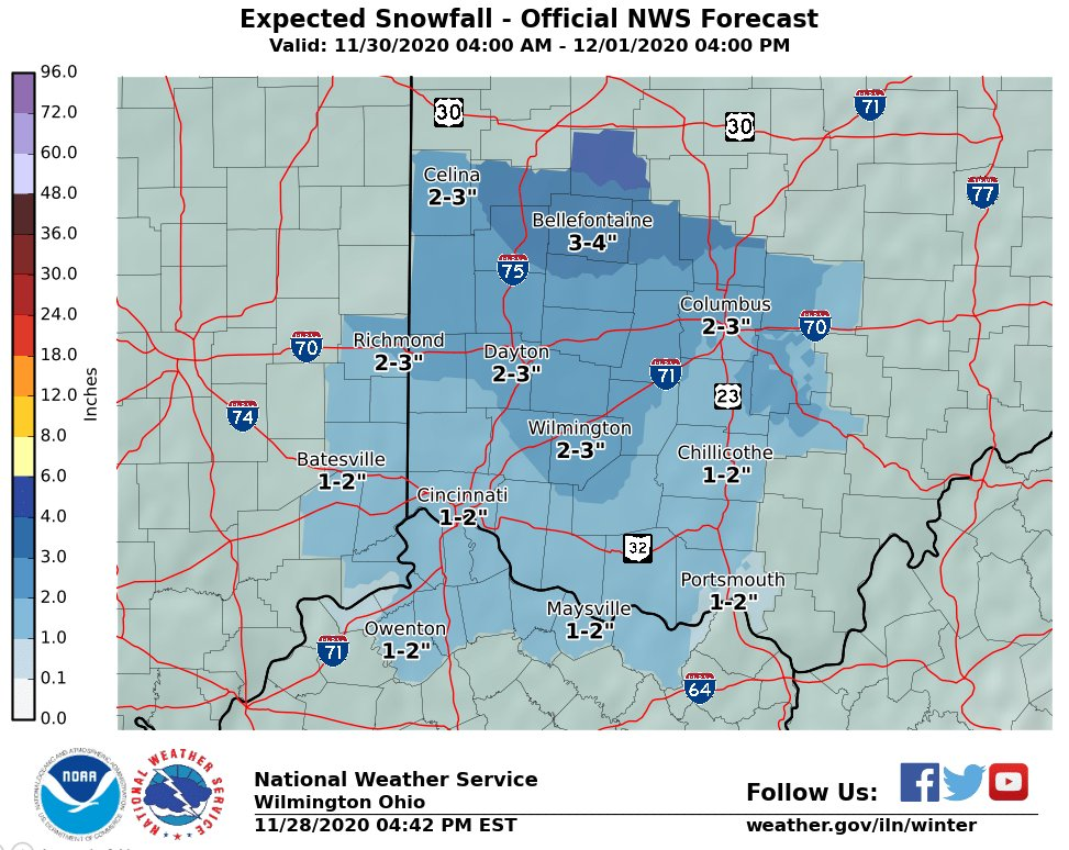
All roads lead to Bellefontaine?
")

I mean if you are going to drive all the way to OH, it might be even better to drive to Mansfield instead. I'm not sure. Based on this map I would say go to Mansfield.
-
1
-
-
Just now, vpbob21 said:
Yeah I think Bellefontaine would be a great place to be in this setup. I think that area was the jackpot zone when Sandy came through here a few years ago.
On second thought, I agree. Ditch Lima, go to Bellefontaine !
-
1
-
-
3 minutes ago, jrips27 said:
Greetings all,
I’m thinking of driving up from the Atlanta area for Sunday-Tuesday and getting a cheap hotel somewhere in West/SW Ohio to see some flakes fall. Working from home for now so that allows me to go anywhere there is WiFi.
Knowing quite literally nothing about Ohio - any tips on good spots that typically do well in these changeover setups? I was looking for somewhere around Dayton since it’s a bit shorter drive but willing to go anywhere. Bellafontaine caught my eye cause it sounds more elevated.
EURO backed off a little bit but still a good thump (especially by Atlanta standards
 )
)
I know Dayton would be closer but you may want to consider going just a little further north. Maybe Lima.
-
1
-
-
Just now, Powerball said:
It's all relative.
Down south, they get thrilled about seeing any amount of snow.
But even in places in the mid atlantic, they get excited over just a little snow.... Seems like in the midwest it takes more for people to get excited.
-
2
-
Dec 29-Jan 2 potential storm event
in Lakes/Ohio Valley
Posted
It's a winter wonderland in the Indy area. Wasn't expecting it to snow tonight.