

Modfan2
-
Posts
2,346 -
Joined
-
Last visited
Content Type
Profiles
Blogs
Forums
American Weather
Media Demo
Store
Gallery
Posts posted by Modfan2
-
-
Why didn’t BOX extend Red Flag warnings into CT zones? Just as dry and going to be just as windy.
-
1 hour ago, Ginx snewx said:
Thompson Ct @Modfan
Dispatch believes this to be a large brush fire between Labonte Rd and I395
Listen lol! Didn’t catch a size; but I think it could be a long weekend for Eastern Ct Fire Depts
-
1 minute ago, Ginx snewx said:
I think we may get some beneficial rain
.thumb.png.6b427d5d8c0377f83fc88bf91e8b50b7.png)
.thumb.png.65919e354ae8c7ce4810cf3c0748fbcb.png)
.thumb.png.5f3552521dc264ed69f3d45134924899.png)
.thumb.png.b4ada9b37d13f0bbcf805a927bb7a42f.png)
Good for next week, but yesterday’s storm and the nice stretch of weather thru the weekend is going pose serious brush fire threat especially if people decide to burn their downed tree Limbs and associated debris
-
 1
1
-
-
3 minutes ago, Ginx snewx said:
Thompson got smoked
Thompson and Woodstock.
-
Lots of trees down in Northern Windham County
-
1
-
-
Lots of trees down S ORH County N Windham County
-
6 minutes ago, CoastalWx said:
We blow today. May not be widespread but could see gusts 45kts in a lot of areas. Maybe isolated higher.
Won’t need much to bring some limbs and power lines down; Brush Fire threat
-
43 minutes ago, Ginx snewx said:
Crispy out here. Humidity up this morning hoping even for a light shower. Not liking this.
Good thing you caught it, 50x50 still decent size. Gonna have to watch for rekindle as it may have gotten into the roots
-
Kevin’s lawn starving for rain and we got 12” here in 24 hrs with more to come due to a stalled cold front.
-
Tree/wire down calls starting to pour in IJD area
-
1
-
-
Wagons west? Kevin still with water tanker deliveries for his well on that run!
-
13 minutes ago, Ginx snewx said:
Congrats DIT on joining the extreme team

Fire fighters in Thompson (near Ma Line) have been working the same 5 acre brush fire since July, it’s deep in the ground and breaking containment
-
 1
1
-
-
Weird that all of MA is under a Red Flag warning but N CT Is not?
-
Fall Brush fire threat a real concern especially with breezy conditions today and no rain until at least Friday. 100 acre fire earlier this week across from IJD
-
20 minutes ago, Ginx snewx said:
She gone, wagons east

EPS not so good on Sally, time will tell.
-
2
-
-
1 hour ago, Typhoon Tip said:
Quick thought on TD 19...
Katrina sends messages from the grave not to count on southern Florida's interesting geology to be as inhibitory as the standard decay/inhibition forcing that occurs when TCs encounter land.
Few may recall... Katrina actually maintained intensity and then gained 10kts of velocity strength prior to even leaving the southern Penn en route to the Loop Current ... That region is flat, and the ground is humid with deep soil moisture and most importantly, is not larger than the circulation domain of the cyclone, so arms and inflow jets can still access some latent heat source... particularly if TD 19 were to stay S of Miam and only partially eclipse ..
I'm curious if this one may gain enough strength/momentum like Katrina did to withstand Florida's southern flat wet hot land... heh
We have a TS watch here now and breezy/squally at the moment. One other trait S FL offers from South of Lake Okeechobee is the moist Everglades and depending how hot and wet if a summer we have had it can be a great potential fuel source for TC
-
GFS/Euro show that wave coming off Africa near DR; of course being 10 days we will see if there is any consistency. Having generator inter-lock installed right now
-
1
-
-
Arrived in Sanibel this afternoon and a balmy 97 at the coast; Steama!
-
2
-
-
Just now, Ginx snewx said:
Short term droughts affect vegetation and shallow dug wells. Long term droughts affect the above as well as ground water, reservoirs, river flows.
Fall Brush Fire Season?
-
Just now, cheese007 said:
People will be screaming BUST if those end up a bunch of fish storms because of course they will
If that ridging is in place in the Canadian Maritimes there are not going to be a lot of recurves
-
2
-
-
15 minutes ago, ORH_wxman said:
Yeah hard to get big surprises now. E MA/RI/SE CT had a good one on 1/30/18....weak 2-3" event forecasted and they got blitzed with 6-8". Thats prob the last good one i cant think of off top of my head in SNE.
You could maybe fit Dec 1-3 last year into that in parts of SNE....nobody expect nearly 2 feet out just east of BAF/CEF....clocked with firehose overnight I remember.
Wasn’t there a storm in the 11-14 range and we were forecasted to get 7” and I woke up to 20+? I remember waking up at 2am to 7” and it then Snowed 3-4” an hour until like 7am
-
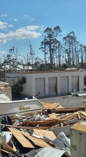
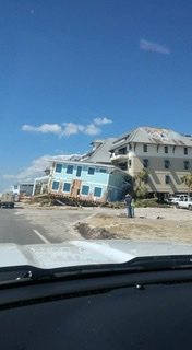
I took these while working recovery in the Pan Handle; we were setting up in the Mexico Beach Public Works yard, 3 blocks from the beach and the water line was 7ft in their garage bays.
-
1
-
-
24 minutes ago, Damage In Tolland said:
Your entire viewing area gonna get rocked tomorrow. Ginx to DXR to Union to Greenwich. We wild
Tornadoes in Middletown, wild fires in Bigelow Hollow from the drought
-
3 minutes ago, weatherwiz said:
Debating if I want to do BDL tomorrow or go towards SW CT. Just tough to find good areas with wide open views down there. Could do Newtown...there's a few spots I know. Danbury is a no-no given the COVID spike.
Some nice spots in Glastonbury/Hebron area too
-
1
-
.png.335fcbff0add2a2c7409827b733d2386.png)
.png.5b480dc464a246c9ae2a5c9ff18266ee.png)
.png.6c21a0bc63aaa8be8d803ffc85a0ba4b.png)
.png.5ecd22a4fd43f656a5f81e1d707cd28c.png)


October 2020 Discussion
in New England
Posted
Surprised Box didn’t extend Red Flag warnings into CT Zones; good day to listen to the MA Fire towers.