

Modfan2
-
Posts
2,374 -
Joined
-
Last visited
Content Type
Profiles
Blogs
Forums
American Weather
Media Demo
Store
Gallery
Posts posted by Modfan2
-
-
Union CT area under that banding, might push 10” there
-
Is that band over SE Ma going to pivot back to ORH County?
-
Jeez nice band from ORH right down 395 to Norwich!
-
When posting Obs kindly post where you are located; “here” does nothing.
-
Snow now Dudley Ma (Charlton Line) off Rt 31
-
My sister at 700ft in Charlton Ma (near Oxford line on Rt 20) is mixing
-
When posting observations can you add where you are located. Most know where folks are located, but no everyone.
-
 1
1
-
-
Temps in NE CT dropping down to 37-38 range already, I believe we a flip here much earlier than anticipated
-
Wow at the returns in S ORH County right now, is this the area where the banding sets up?
-
 1
1
-
-
2 minutes ago, weatherwiz said:
if I adjust anything I would probably do the 3-6'' to 4-8'' and the 6-10'' to 8-12'' but that could be pushing a bit. Just a matter of how quickly the flip can happen. If this thing gets it act together even 2-3 hours faster a large part of CT gets crushed.
I think you are good; you could move the 6-12 to the RI border, it’s not all flat land along I 395
-
1
-
-
I think Box will bust low if they stick with 4-6” in NE CT
-
24 minutes ago, CT Rain said:
Mid level magic for me on the Euro. QPF Queens be damned.
Euro 2m temps are a little warm so still some elevation dependence but do think there's a decent power outage threat around here in NE CT.
Snow Monster May be wise to visit the Thompson Hill Common, Woodstock Academy or Pomfret Academy common areas for decent live shots
-
1
-
-
3 minutes ago, CoastalWx said:
Lift is under the DGZ. I want to see a hole torn in the DGZ for this. I think that is more west.
It has the look from Foxborough area to NW RI into NE CT could do well baring any further shifts
-
35 minutes ago, Damage In Tolland said:
Decent first call from Maxon (NBC30). I’ve got 5-10” in his 4-6”. Should be fun tomorrow for everyone

And if it heavy and wet 4-6” is enough to take some limbs down
-
Pretty soon it will be congrats Down East Maine and NS if it keeps trending east
-
Someone ORH west going to get a Birch Bender
-
5 hours ago, WinterWolf said:
Hey, what’s a week and a half right?
that's a DC/Virginia to Maine Mauling right there. Thanks for the visual 4Seasons.
Lock it!
-
 1
1
-
-
36 minutes ago, ORH_wxman said:
The arctic pattern is just utter trash in the medium range so it’s going to take a lucky break to get a good snow event. You’ll have a much better chance there than down here of course, but even NNE will need a little help this early in the year with that type of arctic.
Icing?
-
Does the line hold together as it pushes East?
-
4 minutes ago, powderfreak said:
Not to take away from the high-wind disco, but that is extremely cool to step outside your house and see a group of humans shot into space.
Won’t lie, it’s pretty cool.
-
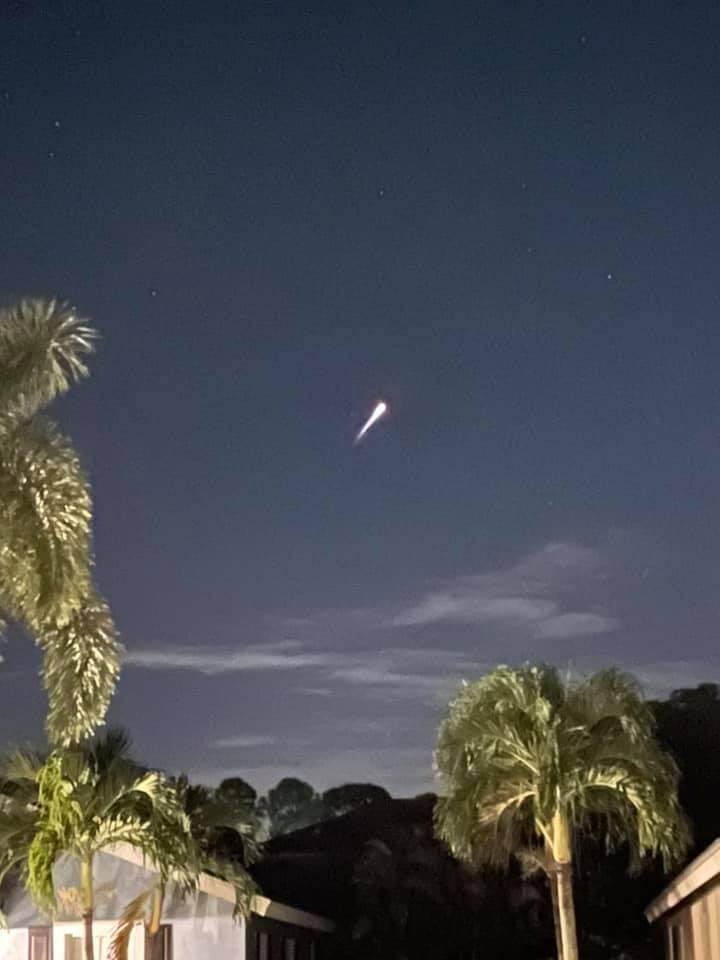
Caught the SpaceX Falcon launch from the driveway.

-
15
-
-
1 hour ago, weathafella said:
FWIW-around midnight last night it got wild with frequent lightning near Chicago.
Summer derecho part II?
-
1 hour ago, Damage In Tolland said:
Every piece of guidance has 50-70mph gusts
Box tosses, enjoy your 40mph gust. The only thing coming down is the size of your leaf piles.
-
1
-
2
-
-
2 minutes ago, OSUmetstud said:
Lol. Alright. Maybe you should check out some reputable sources.
https://www.nature.com/articles/d41586-020-02801-8
https://www.cdc.gov/coronavirus/2019-ncov/more/masking-science-sars-cov2.html
I am fine with my sources; were the dates and data on those charts not accurate?
December 2020 Discussion
in New England
Posted
Freezing drizzle in Windham County in CT into Worcester County.
Multiple accidents along I 395 from Auburn Ma to Plainfield CT