

Modfan2
-
Posts
3,468 -
Joined
-
Last visited
Content Type
Profiles
Blogs
Forums
American Weather
Media Demo
Store
Gallery
Everything posted by Modfan2
-

May 2024 Discussion - Welcome to Severe Season!!!!
Modfan2 replied to weatherwiz's topic in New England
Decent storm just to my NW in Ashford/Eastford CT area; hearing Thunder here. Does this dampen chances for later on?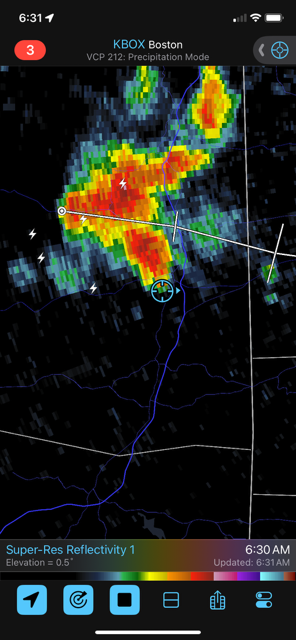
-
May 2024 Discussion - Welcome to Severe Season!!!!
Modfan2 replied to weatherwiz's topic in New England
I know next week has the potential for not being that good, what’s it looking like Cape next week? Daughters school trip and try to pack accordingly -
May 2024 Discussion - Welcome to Severe Season!!!!
Modfan2 replied to weatherwiz's topic in New England
54F for a low, another great night sleeping with windows open!! -
May 2024 Discussion - Welcome to Severe Season!!!!
Modfan2 replied to weatherwiz's topic in New England
80F here in E CT, nice breeze with low humidity, can we bottle this? -
May 2024 Discussion - Welcome to Severe Season!!!!
Modfan2 replied to weatherwiz's topic in New England
No need for AC last night, enjoy the cool night and open the windows; temp down to 53F. Waited 8 years of being in FL to be able to open the windows and enjoy natural AC -
May 2024 Discussion - Welcome to Severe Season!!!!
Modfan2 replied to weatherwiz's topic in New England
Up to 80F here in the Quinebaug valley, nice day!! -
May 2024 Discussion - Welcome to Severe Season!!!!
Modfan2 replied to weatherwiz's topic in New England
First possible heat wave of the season this week with temps possibly touching the low 90’s here in SNE, enjoy! -
May 2024 Discussion - Welcome to Severe Season!!!!
Modfan2 replied to weatherwiz's topic in New England
Meh- rained during my daughter’s soccer game in RI, not fun! At least it wasn’t cold! -
May 2024 Discussion - Welcome to Severe Season!!!!
Modfan2 replied to weatherwiz's topic in New England
Light rain and 55F here in E CT, 0.04 so far -
May 2024 Discussion - Welcome to Severe Season!!!!
Modfan2 replied to weatherwiz's topic in New England
Looked mostly like a western New England thing, cloudy weekend for most. -
May 2024 Discussion - Welcome to Severe Season!!!!
Modfan2 replied to weatherwiz's topic in New England
If only this firehouse happened 3 months ago….over an 1” here in E CT, more the further south you go along I 395 -
May 2024 Discussion - Welcome to Severe Season!!!!
Modfan2 replied to weatherwiz's topic in New England
Hoping we can salvage tomorrow afternoon, overnight and tomorrow morning looks wet. -
May 2024 Discussion - Welcome to Severe Season!!!!
Modfan2 replied to weatherwiz's topic in New England
Are the northern lights visible again tonight and will we be clear enough to see them if they are? -
May 2024 Discussion - Welcome to Severe Season!!!!
Modfan2 replied to weatherwiz's topic in New England
Down to 37F here in the valley in E CT, glad it was going to a mild 3-day stretch. -
May 2024 Discussion - Welcome to Severe Season!!!!
Modfan2 replied to weatherwiz's topic in New England
Cloud cover here, WTF! -
May 2024 Discussion - Welcome to Severe Season!!!!
Modfan2 replied to weatherwiz's topic in New England
So much for just a few spot showers on Sunday, rain and 46F here. 0.07 so far on top of 1.41 on Wed, waiting for Stein to make an appearance. -
May 2024 Discussion - Welcome to Severe Season!!!!
Modfan2 replied to weatherwiz's topic in New England
Great call by @CT Rain with the severe threat, maybe he should start future severe threads. Not a lot in terms of wind or lightning but the hail was pretty neat to see. -
May 2024 Discussion - Welcome to Severe Season!!!!
Modfan2 replied to weatherwiz's topic in New England
Just had a decent hail core come over in Brooklyn, marble size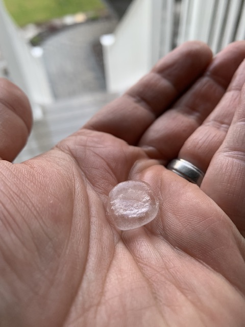
-
May 2024 Discussion - Welcome to Severe Season!!!!
Modfan2 replied to weatherwiz's topic in New England
Has to be some decent rainfall totals in Ashford/Eastford area -
May 2024 Discussion - Welcome to Severe Season!!!!
Modfan2 replied to weatherwiz's topic in New England
And another severe cell coming this way, overperfoma! -
May 2024 Discussion - Welcome to Severe Season!!!!
Modfan2 replied to weatherwiz's topic in New England
Just went through here, a bunch of CG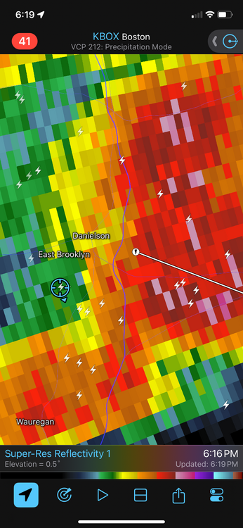
-
May 2024 Discussion - Welcome to Severe Season!!!!
Modfan2 replied to weatherwiz's topic in New England
Little training from DIT into Windham county -
May 2024 Discussion - Welcome to Severe Season!!!!
Modfan2 replied to weatherwiz's topic in New England
Picture off WINY radio in Putnam CT of hail
-
May 2024 Discussion - Welcome to Severe Season!!!!
Modfan2 replied to weatherwiz's topic in New England
Decent hail in the Holland/Sturbridge/Union -
May 2024 Discussion - Welcome to Severe Season!!!!
Modfan2 replied to weatherwiz's topic in New England
Looks like some decent rotation in Sturbridge


