wxmvpete
-
Posts
76 -
Joined
-
Last visited
Content Type
Profiles
Blogs
Forums
American Weather
Media Demo
Store
Gallery
Everything posted by wxmvpete
-
I hope this link to the CIPS Analogs works. https://www.eas.slu.edu/CIPS/ANALOG/DFHR.php?reg=EC&fhr=F108&rundt=2025021512&map=thbCOOP72 Just clicking around, I thought the January 25-26, 1987 event has some similarities and was at least closer to the snowfall look you mention. Obviously it has some flaws, but the MSLP and 850mb representation isn't too dissimilar. But to your point, if you look at the mean snowfall probs, most of those snowfall areas were more north.
-
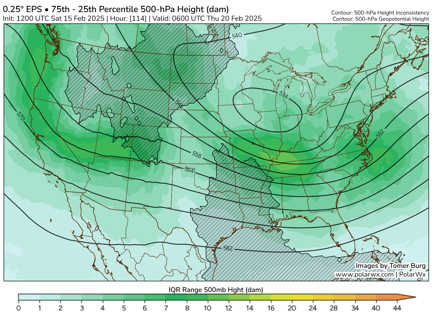
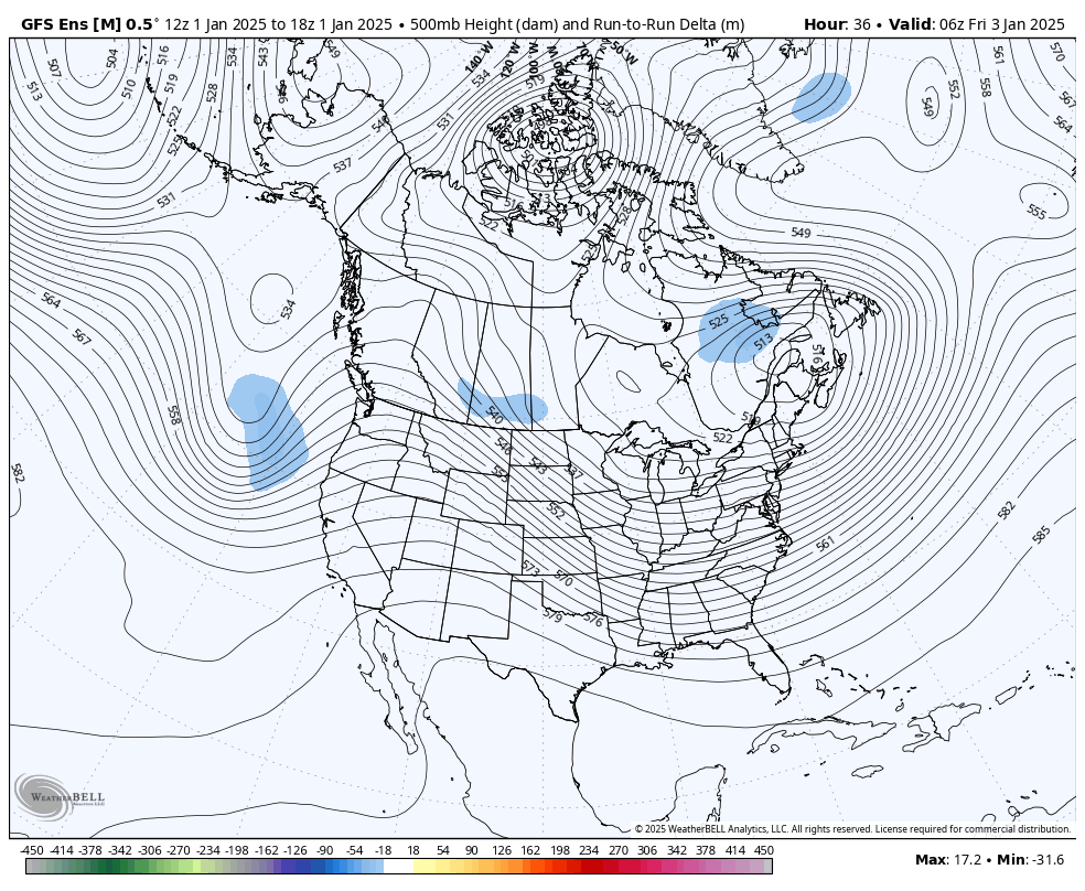
From an "upper-level axis" standpoint, the initial lead wave provides modest PVA aloft to where it still produces WAA "front-end thump" type snow probably regardless for most of the region. But the last 5 runs of the EPS shows some fundamental changes. 500mb trend loop: There is a clear separation of the TPV lobe over the Midwest and the lead southern shortwave. When they were phased, a stronger source of PVA/500-700mb WAA was placed more favorably over the Mid-Atlantic. As the two separate, the TPV which was faster and could help capture the leading low-level circulation spawning out ahead of the lead southern shortwave trough simply isn't fast enough or amplified enough to "tug" on the southern feature and key the storm closer to the coast. 300mb streamlines loop: This loop shows the faster southern S/W and separation of these two features in action. The mean 300mb axis is faster and heights are not necessarily as suppressed, but less influence in connection with the TPV is making the southern S/W so progressive and WAA aloft is weaker to where heights are not as high from previous runs. Final graphic via Tomer Burg's site (500mb skewness): Now the question is: Is this a trend or noise? There is still a case to be made that the TPV could speed up, and in turn catch up to the southern shortwave trough. The speed/depth of the lead shortwave trough can also change. The EPS skewness page, which shows heights that are more sensitive or less confident in placement/strength, shows the TPV heights in the Mid-South being closer to yellow (still higher than usual spread), while some lighter green colors are off the Mid-Atlantic coast. That could be more related to the strength, speed, and orientation of the trough axis. This is unfortunately what we get with Miller B's. Despite model guidance improvements over the years, these subtle and intricate details: axis position, timing, depth, and interaction can make the difference in a 50-100 mile shift. This could very well shift north with the lead shortwave and still produce a healthy SECS without the help of the TPV. But that TPV merger will be the key in a MECS or larger.


-
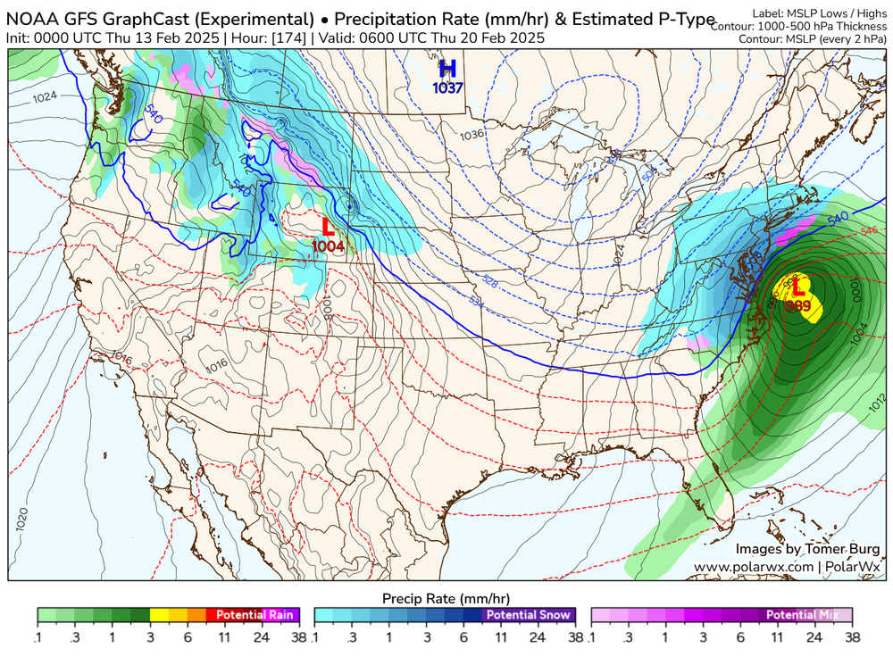
Will be a nice test for the GFS Graphcast as well, which has been pretty insistent that this storm makes the turn up the coast.
-
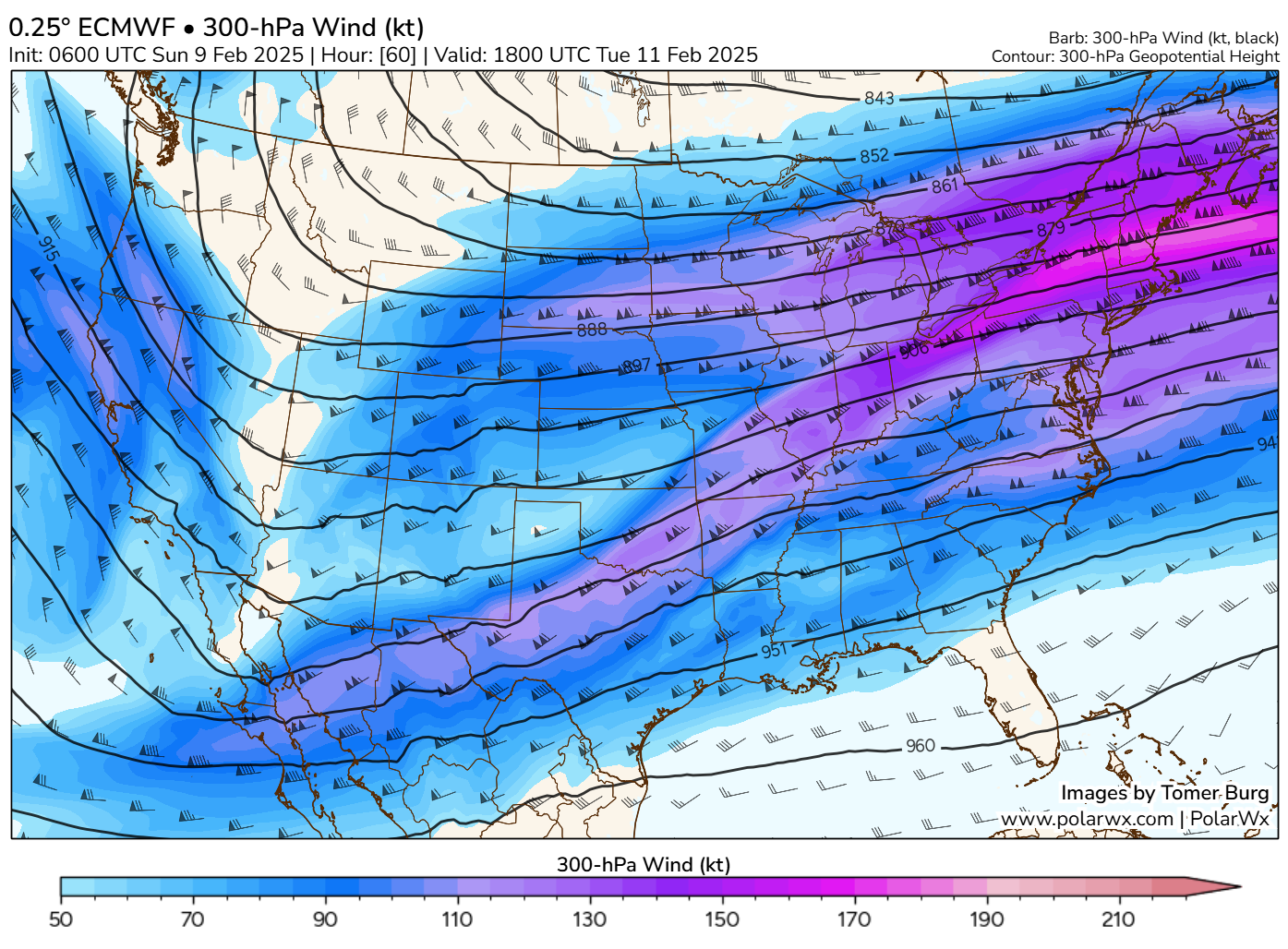
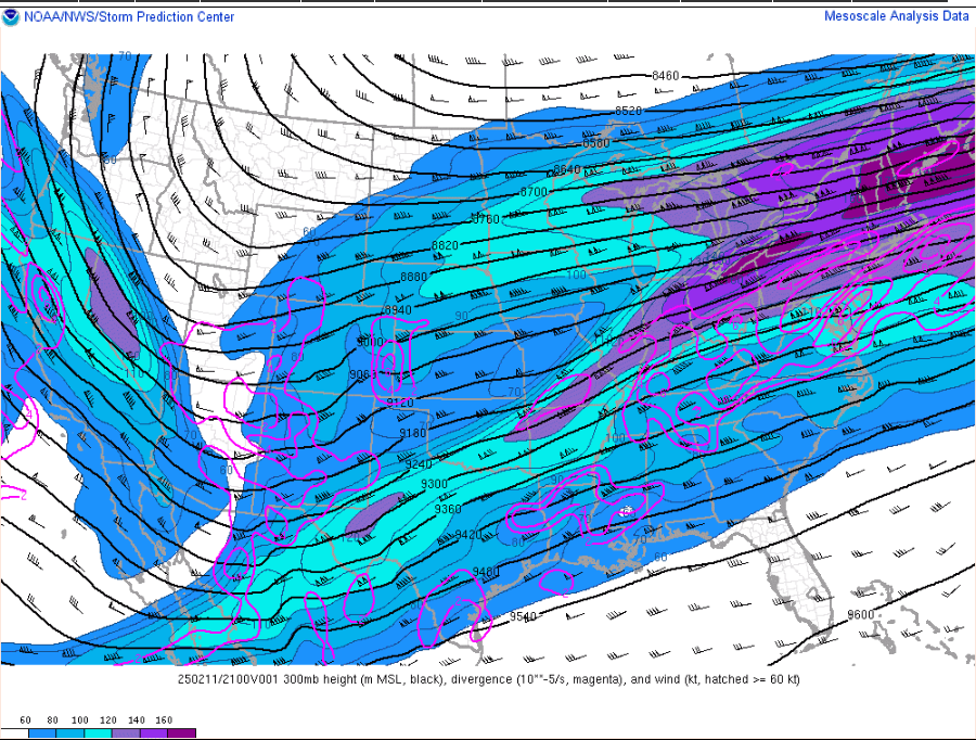
We have the divergent right-entrance region of a 300mb jet streak aligning with sufficient mid-level moisture aloft to thank for the prolonged period of snow into this evening.
-
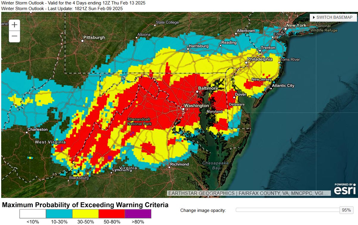
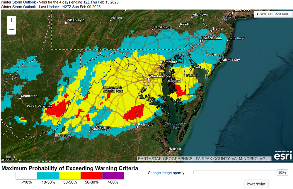
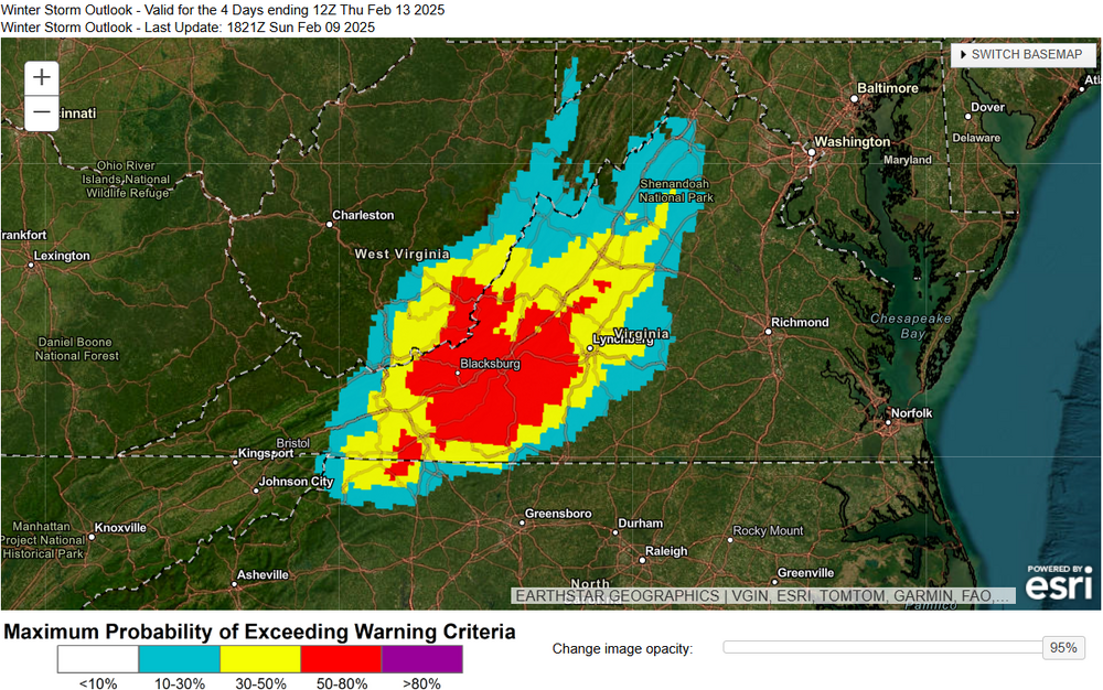
The latest 18Z WSO (probabilities of exceeding warning criteria) expanded noticeably to the north. This is likely taking into account the more recent CAMs and northern extent of some of the ensembles. We've seen those southern tracks still in place but that's a notable increase across northern VA on east into the eastern DC/Baltimore metros. I also added the WSO probabilities for Freezing Rain for southwest VA. A strong signal for significant icing in those parts.


-
Last five runs of the GEFS for 24-hr snowfall probabilities >4". Shows the current 12Z GFS snowfall footprint is south of the ensembles while also being south of the rest of guidance with snow in south-central VA. Still likes northern VA most. Note however with the warm nose aloft closer to the central VA and a pretty narrow DGZ, I think those areas on the southern periphery (including along and south of I-66) may be hard pressed to have SLRs of 10:1 for the peak of the event. It's why snowfall is less on the Kuchera compared to the straight 10:1 SLR maps.
-
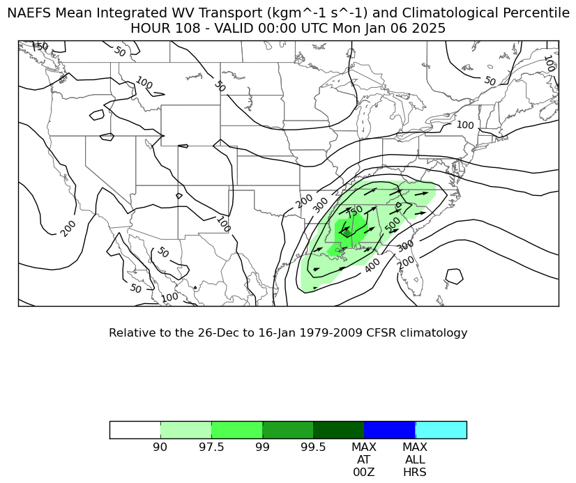
We've seen some subtle north trends over the past 12-24 hours. Using Tomer Burg's site, we can see the 700mb heights have ever so slightly increase over the past 5 runs over the Mid-Atlantic. This could be a combination of the primary system being a little slower, the northern confluence exiting a smidge faster, the increased latent heat release in the south aiding in slightly higher heights, or frankly all of the above. I'm a sucker for Q-vectors (always have been) and Tomer's site does show Q-Vectors converging better over the Mid-Atlantic on Tuesday, implying better mid-level convergence over the region that aligns favorably beneath the divergent right-entrance region of a roaring 175 knot 300mb jet streak over New England. Not to mention a healthy IVT that supplies plenty of moisture to work with. The mesoscale processes involved do show a good consolidated area of 850-700mb FGEN, but be cognizant of where the 700mb FGEN aligns. We've seen at least one instance where the 700mb FGEN has led to a stronger northern band of snow (thinking of an event over north-central PA a month ago or so). Regardless, the synoptic-scale look is one that can favor some hefty snowfall rates Tuesday afternoon into Tuesday night, but this is still be TBD over the next 24-36 hours as guidance starts to key in more on those mesoscale factors. WPC's Winter Storm outlook shows mostly 30-50% probs for snowfall amounts exceeding warning criteria for effectively all of northern VA and a good chunk of MD along and south of I-70 for the time being. >50% probs are farther south.
-
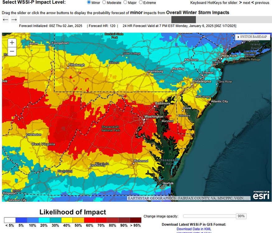
My heavy snow discussion tonight went into some of the model differences, the synoptic/mesoscale setup, and how the probabilistic snowfall totals and impact guidance looked as of tonight. ...Mid Atlantic and Northeast...Day 3......Confidence is increasing in a disruptive winter storm from theMid-Atlantic to the Northeast with locally heavy snowfall possiblealong the I-95 corridor...Model diagnostics: Over the past 24-36 hours, guidance has comeinto better agreement on a deepening 500mb trough over the OhioValley and higher height rises in the Atlantic south of Bermuda.AI-based guidance (ECMWF-AIFS and GFS GraphCast) have been showingthis increasing potential over this time span while ensembles(ECMWF-EPS, GEFS, GEPS) have all gradually trended snowier aswell. While this is the case, deterministic guidance still showsthe lingering uncertainties with the 500mb trough's amplitude andposition 12Z Sunday. The 00Z GFS is slightly deeper vs the 00ZECMWF. The 00Z CMC is similar to the ECMWF 500mb disturbance'sstrength, but with less confluence over the Northeast, allowingfor a more storm track on the northern side of the trackdistribution. The UKMET also has a similar look to the Canadian,albeit with a colder boundary layer setup given stronger confluenceover the Northeast. Overall, the AI-based guidance and the trendsin the ensembles provide an increased confidence in a synoptic-scale setup that is boosting confidence in a winter storm from theMid-Atlantic to the Northeast, but more specific details on stormtrack still need to be ironed out over the next 24-36 hours.Synoptic & mesoscale analysis: The approaching upper-level troughSaturday night will amplify over the Ohio Valley and place astrengthening 250-500mb layer-averaged jet streak over the Mid-Atlantic by Sunday morning. NAEFS shows 200mb and 500mb winds overthe Southeast U.S. are above the 90th climatological percentileand foster healthy upper level divergence aloft on Sunday. Atlower levels, a cold front Saturday night will stall out along theMid-Atlantic coast and into southern Virginia. The front, residingbeneath the synoptically-favorable jet stream setup, will spawn anarea of low pressure Sunday morning in the Carolinas and graduallystrengthen as it heads for the Mid-Atlantic coast Sundayafternoon. The heaviest banding of snow is likely to reside northof 850mb frontogenesis, which will become more and more pronouncedas the 850mb low forms somewhere along the Jersey Coast and tracksnortheast towards Long Island and the MA Capes Sunday evening. Thestorm is a progressive one, but given the sufficient synoptic andmesoscale processes, the deformation zone of heavy snow would bemore than capable of generating ~1"/hr snowfall rates, especiallyfor areas from the Delaware Valley on north and east through theTri-State area and into southern New England where they are morelikely to have better mesoscale forcing as the 850mb low deepensSunday night.Timing & snowfall/impact probabilities: As mentioned before, thisis a quick hitting system that is all but gone by midday Monday asit races toward the Canadian Maritimes by Monday afternoon. Snowis forecast to be at its heaviest Sunday morning and afternoon forthe DC/Baltimore metros, the Philly/NYC metros Sunday afternoonand evening, then across southern New England Sunday night intoearly Monday morning. Latest WPC probabilities show moderate-to-high chances (50-70%) for snowfall totals >4" from the DelawareValley on north through the Lower Hudson Valley and across southernNew England. Low-to-moderate chances (30-50%) for >4" extend asfar north and east as Downeast Maine. WPC probabilities even showsome spotty low chance probabilities (10-20%) for snowfall totals>8" in parts of southern New England. The DC/Baltimore metro areassport low chance probabilities (10-30%) for >4" of snowfall at themoment, while the Philly and NYC metros are in the moderate range(40-60%) for >4" of snow. While exact amounts remain unclear, theWSSI-P Minor probabilities are >60% for the full length of I-95from DC to Boston, indicating the heightened potential forhazardous travel conditions Sunday into Monday. WPC has initiated KeyMessages for this event and can be viewed at the bottom of thisdiscussion.Mullinax
-
Haven't dug into it a ton, but at first glance, this observation plus a weaker/flatter 850mb jet is resulting in less WAA at low levels (more WSW orientation aimed at the Eastern Shore, not more SW aimed at the Mason-Dixon) is one of the culprits. I still see some 700mb FGEN up near the M-D so that's why some of these totals aren't too sharp on gradient to the north and still reach warning criteria for parts of northern MD, but should that trend weaker, then that northern area (while having high SLRs) will be squeezing out every bit of moisture to meet warning criteria.
-
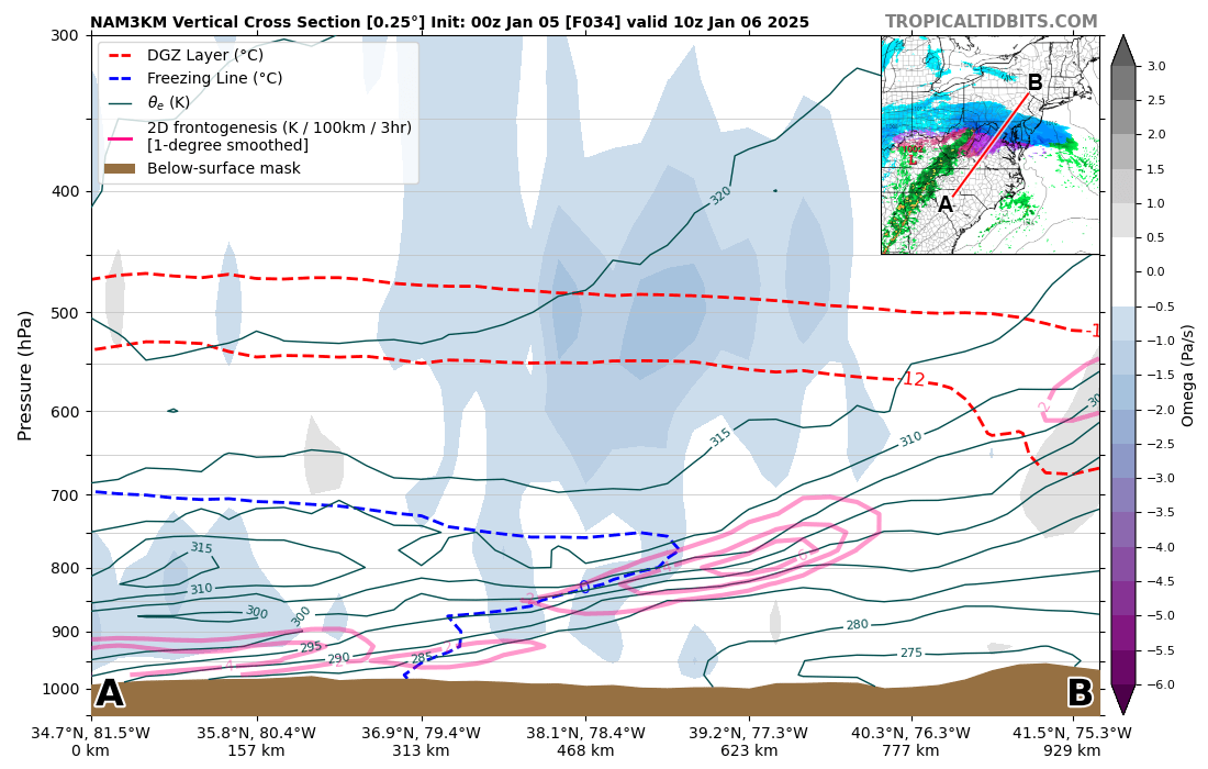
The 3kmNAM cross-section early Monday morning is a textbook FGEN/isentropic ascent setup. Also depicts the warm nose very well.

-
That's an excellent breakdown of why they felt more confident on warnings for southern/central zones and maintaining watches for the northern zones. Well done, LWX!
-
My colleague Josh Weiss wrote an exceptional discussion for the major winter storm portion. I took care of the other parts of the CONUS today. Lucky me...lol.
-
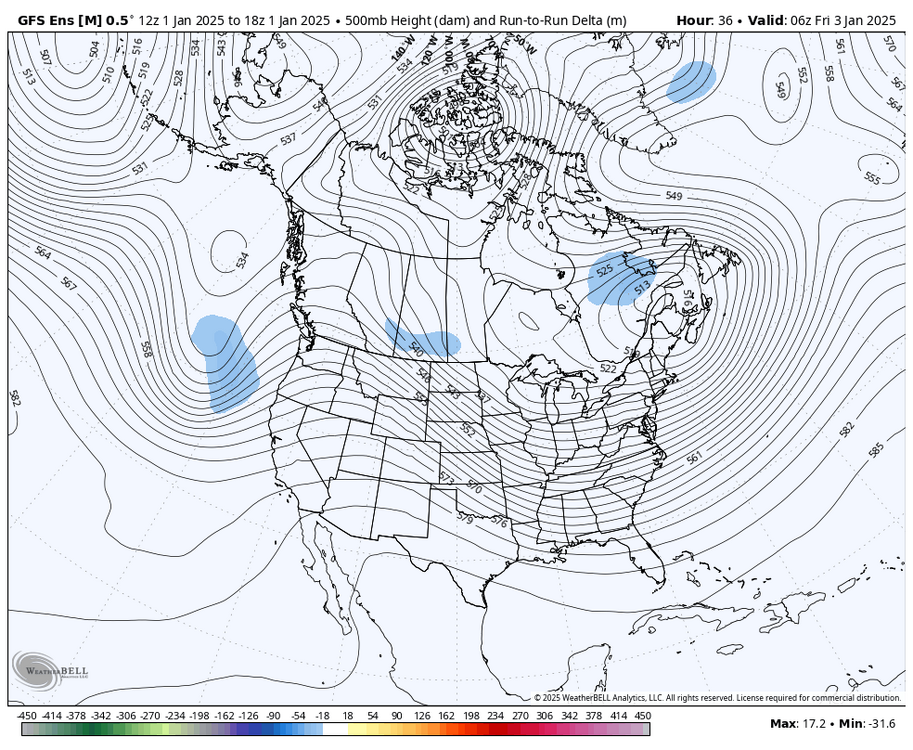
Perhaps just as notable is the separation from the weak shortwave over southern Ontario and eastern Michigan. It interacted less with the primary trough and the lowest heights rose from ~540dm to ~546dm. Funny enough though, the 06Z GFS had more height rises out in front of the primary trough (maybe just a timing thing, i.e. slower this run). All that to say-- it's a complex setup and there are enough players here that we may noy get more agreement on guidance until we get closer to CAMs range where we also get better sampling of convection in the south, and the shortwaves revolving around the 500mb gyre to the north come into focus.
-
Oh for sure. With that event, I remember the forecast quickly changing inside of 48 hours. Between that event and the Northeast bust last Feb, there should always be some sort of check point reviewing guidance and a forecast for us to ask "where could this go wrong (or less amounts)". Still puts into perspective that we are >72 hours from the event starting locally. It's looking for those clues in the short term starting tomorrow with things like "is the LLJ/WAA stronger?, are the sub-freezing wet-bulb temps in the boundary layer sticking around longer than expected?". The increasing probabilities in ensembles help provide more confidence, but for all the "we have 60% chances for >3" of snow where I am" graphics there are, there's also a "well, there's 40% chance it's less". I'd like to think by the 00Z runs tomorrow, we'll be in a more clear picture of where the forecasts stands.
-
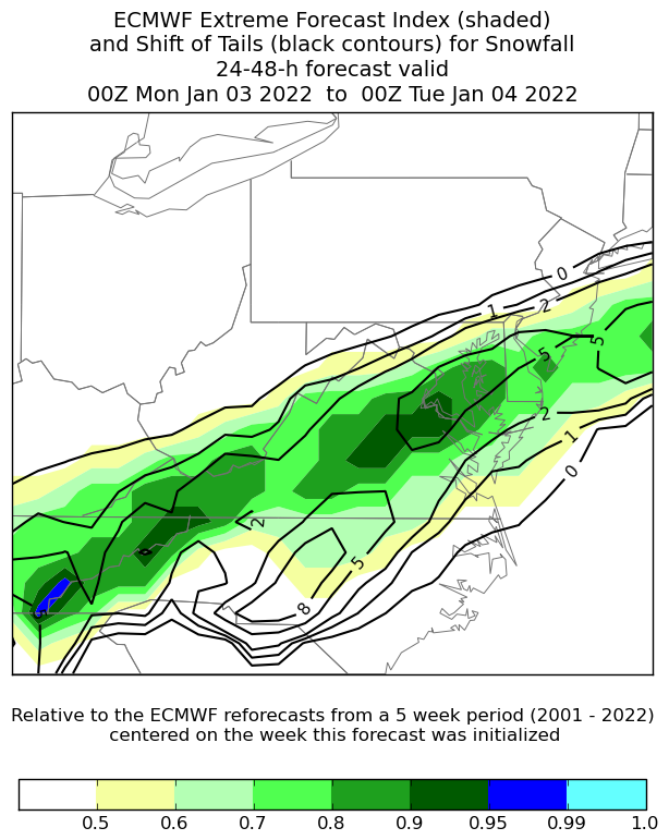
Yep, it was the January 3-4, 2022 event. Here's what it looked like the day before for an example, and we know what it ultimately did in those areas.

-
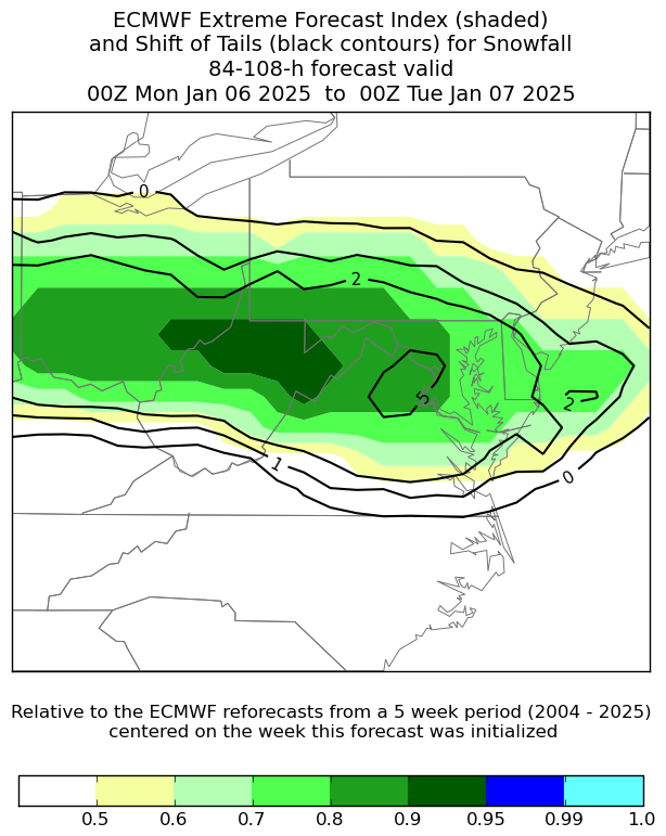
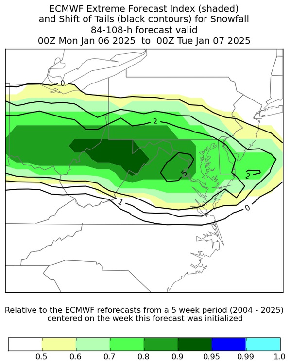
One of my favorite products in assessing the potential for extreme events is the ECMWF's Extreme Forecast Index (EFI). The link for the page is here: https://satable.ncep.noaa.gov/efi/. To read up on it more from the ECMWF, you can visit here: https://confluence.ecmwf.int/display/FUG/Section+8.1.9+Extreme+Forecast+Index+-+EFI%2C+and+Shift+of+Tails+-+SOT. If you haven't seen it before, in quoting the ECMWF page, the EFI "compares the medium range ensemble forecast probability distribution of an event to the M-climate distribution for the chosen location, time of year and forecast lead time. The underlying assumption is that, if a forecast is anomalous or extreme with respect to the M-climate (re-forecast database over the past 20 years), the real weather is also likely to be anomalous or extreme compared to the real climate. Simple probabilities derived from the ensemble (e.g. the probability that forecast temperature >32°C) do not highlight the differences in the distributions of forecast. However, EFI will do so because it accounts for the distribution of all the ensemble members. EFI takes values between +1 and -1. Experience suggests: EFI values between 0.5 to 0.8 (irrespective of sign) can be generally regarded as signifying that ““unusual”” weather is likely, EFI values above 0.8 (irrespective of sign) as usually signifying that ““very unusual”” or extreme weather is likely. " In this case using the new 12Z ECMWF EFI, maybe it is because it's been so long, but we do have some >0.8 values in northern VA that I can't recall seeing before (granted this product is still fairly new). Note as well is the Shift of Tails area. The Shift of Tails according to ECMWF "...compares the tails of both distributions of M-climate and ensemble based on the 90th and 99th (upper tail) percentiles...The SOT index complements EFI by providing information about how extreme an event could potentially be. Specifically, it compares the tails of the ensemble and M-climate distributions." Usually, my eyebrows rise some when we have a ~0.7 and >1 SoT look. We have a >0.8 and even a 5 SoT in Northern VA. This tool can be used to show the event that the ECMWF ENS distribution suggests a very unusual snow event is likely based off the 20-year running climo, but some of the members are on the more extreme side given the higher SoT.
-
I don't get enough practice posting in here to see what is too much haha. I'll try to shorten my posts more!
-
^This. There's been one instance in wake of the 2016 blizzard (January 2019 from what I see on xm-ACIS) when Dulles exceeded Winter Storm Warning criteria. To get that event in any capacity would be a win for snow lovers (like me hah).
-
To see the Probabilistic Winter Storm Severity Index (WSSI-P) showing moderate-to-high chances (50-70%) for most Minor Impacts for most on this forum should instill some confidence that we're dealing with a disruptive event Sunday night into Monday. It's a good signal for 4-5 days out on this product that we generate at WPC.

-
A little bit of a break down from the 12Z and 18Z guidance. The main discrepancy remains the strength/tilt of the 500mb trough, although the ridging along the West Coast feature differences too. Using 12Z Sunday as the time of interest, the ECMWF/CMC are most bullish on the 500mb trough while the GFS/ICON are weaker and more positively tilted in the 500mb comparison loop. This is also playing a big role in the strength of the emerging LLJ that is drawing up GoM moisture. Guidance like the ECMWF/UKMET/CMC are a little slower and not only generally deeper, but also positioned at a more neutral tilt. The GFS/ICON are more positively tilted and weaker in general. This has ramifications with the LLJ (850mb heights and winds comparison loop) as the strong SWrly flow shown on the ECMWF/CMC/UKMET yields not only more moisture/QPF, but a strong frontogentical component as well. Now one caveat is watching the 500mb trough over Lake Superior and western Ontario. That feature, should it make it far enough south and trend stronger, could act to suppress the tilt of the 500mb trough in the Plains and Mid-South on Sunday. Should that happen we would see not only a flatter system, but the moisture source is directed out of the WSW more and yields weaker 850mb FGEN. That can be give an take though, right? Seeing the 18Z ECMWF for example, it has a 70kt 850mb jet over northern AL. While that aids in exceptional moisture transport, that warm nose would also be a problem and make ice a bigger story than snow. This setup would be an exceptional FGEN maker, but at dry slotting would be a problem as the upper trough got closer. The NAEFS (last image) shows that even the GEFS/GEPS situational awareness tool shows exceptional moisture transport. That could be a sign of potential trends to come inside of 60 hours, because if that kind of moisture transport exists and more instability can come to fruition, that could sharpen up that IVT more at the Mid-Atlantic. Now most of it is oriented at the Southeast, but should the 500mb trough in the Plains trend stronger in the coming days, that orientation could lead to a better plume of moisture and more QPF to work with. On the flip side, this could cause more ice in parts of the VA Piedmont. Remember the ECMWF is the stronger outlier at the moment, and while the GFS and ICON may be not most folks cup of tea, it is what could happen if this system trends weaker. Lastly, I wanted to share the differences at 500mb from the 18Z GEFS vs the 12Z GEFS. We're still seeing some notable changes just 36 hours into the period, even before the Pacific disturbance arrives. While its becoming more likely we are seeing in some capacity a measurable snow event, these changes on an ensemble still show there's much more to resolve.
-
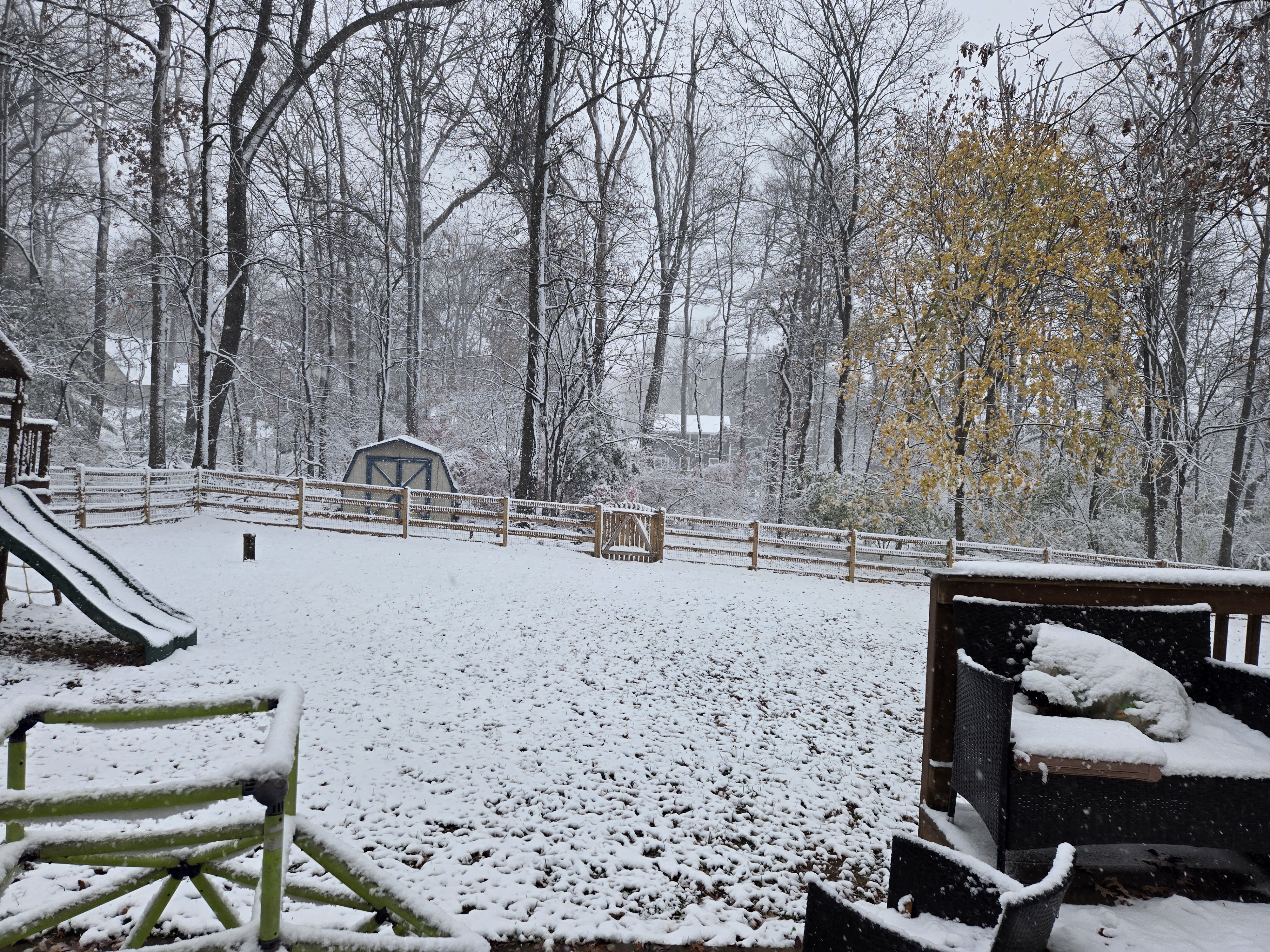
Yeah I'm at 2.7" 6 miles northeast of Westminster. A light but pretty snow falling. One of the negatives with such a good band to the south is the air has to sink somewhere. Looks like northern Carroll and most of Frederick county is dealing with that at the moment.
-
Got about 1.25" northeast of Westminster so far and sitting at 24F.
-
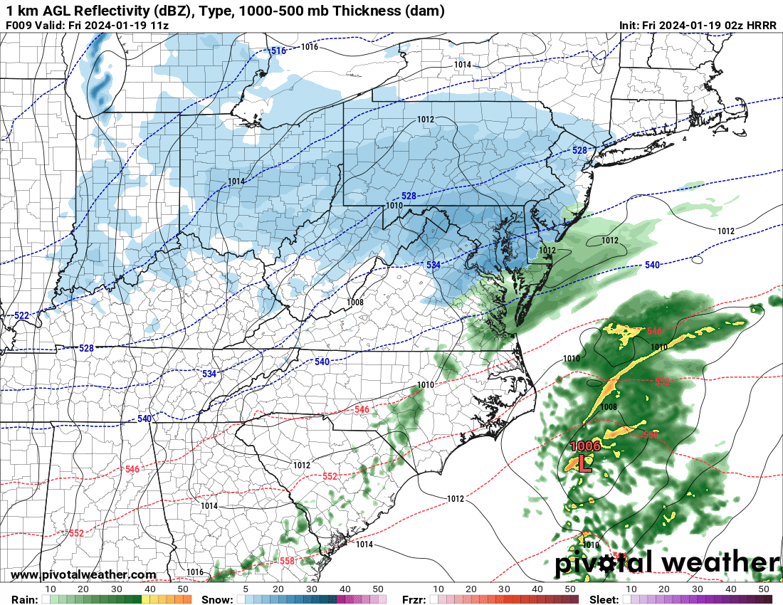
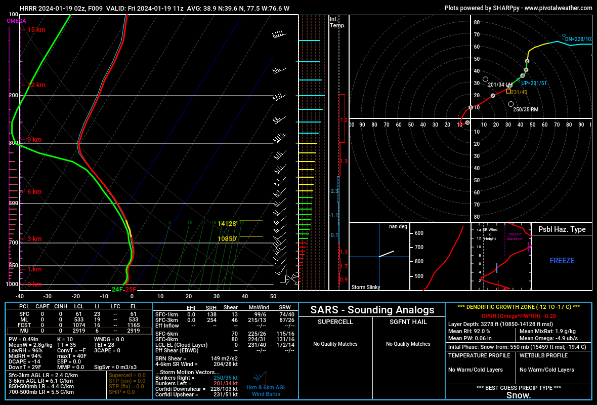
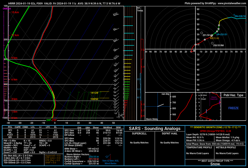
Latest 02Z HRRR at 6AM-- area averaged sounding including most of the DCA-BWI corridor shows a sufficient sounding for some great looking dendrites. We've had more saturated soundings, stronger omega, deeper DGZs in bigger events, but this will still produce some locally heavy snowfall rates and lead to some pretty tough travel conditions. Looks like snow lovers will want to enjoy this one. May not get another real good shot at this again for several weeks.

-
Jan 19th Snow on Snow: the this always works until it doesn't thread
wxmvpete replied to psuhoffman's topic in Mid Atlantic
Absolutely. For just about everyone along and west of I-95 (including the metros), WPC 6-hr averaged SLRs are 10-12:1 generally between 06-12Z, but 12-18Z are 13-15:1 (Catoctins could approach 16:1), then 18-00Z tomorrow are 15-17:1. Question becomes how much moisture & lift can stick around the region that late.- 824 replies
-
- 11
-

-