

nesussxwx1
-
Posts
165 -
Joined
-
Last visited
Content Type
Profiles
Blogs
Forums
American Weather
Media Demo
Store
Gallery
Everything posted by nesussxwx1
-
January 25-26 Winter Storm Potential
nesussxwx1 replied to Ralph Wiggum's topic in Philadelphia Region
Okay, noted. Snowboard around the block has 5". I'm near Blackwood. Northern Washington Twp. Looks closer to what you have. -
January 25-26 Winter Storm Potential
nesussxwx1 replied to Ralph Wiggum's topic in Philadelphia Region
I took several, lowest spot was 5.5". Some over 8". -
January 25-26 Winter Storm Potential
nesussxwx1 replied to Ralph Wiggum's topic in Philadelphia Region
It's already near Vineland lol. Think we have an hour or two left. -
January 25-26 Winter Storm Potential
nesussxwx1 replied to Ralph Wiggum's topic in Philadelphia Region
-
January 25-26 Winter Storm Potential
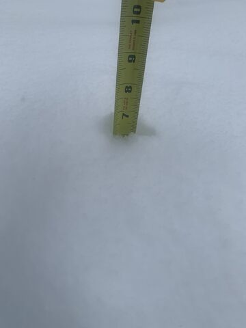
nesussxwx1 replied to Ralph Wiggum's topic in Philadelphia Region
Just measured 6" actually. 4" was an eyeball estimate. Washingtown Twp, Gloucester County. -
January 25-26 Winter Storm Potential
nesussxwx1 replied to Ralph Wiggum's topic in Philadelphia Region
About 4". 18F. RM -
15/-6. Cloudy & overcast with flakes nearby.
-
January 25-26 Winter Storm Potential
nesussxwx1 replied to Ralph Wiggum's topic in Philadelphia Region
18z NAM is snow to sleet. I don't know any model that shows us staying as snow the entire storm. Let's see how long we hold on. -
January 25-26 Winter Storm Potential
nesussxwx1 replied to Ralph Wiggum's topic in Philadelphia Region
Not seeing it. Looks the same. 6-10" Philly. -
January 25-26 Winter Storm Potential
nesussxwx1 replied to Ralph Wiggum's topic in Philadelphia Region
Anyone have the sleet/frz rain map? How much of this is actually snow, I can't see the precipitation maps or soundings. -
January 25-26 Winter Storm Potential
nesussxwx1 replied to Ralph Wiggum's topic in Philadelphia Region
GFS has been poor with thermals all winter, no way I'm trusting it despite how good it looks. I think Philly burbs should do well (6-8"+), there'll be a threat of mixing in the SE burbs in NJ. I'm expecting at least an hour of sleet here after a nice front-loaded dump of snow, highly doubt we see rain but hi-res models will begin to come into play soon. -
Extreme Cold, Snow & Sleet: SECS 1/24 - 1/26
nesussxwx1 replied to TriPol's topic in New York City Metro
Relax. If there's a mix as far north as Morristown, it'll be at the tail end. You won't see hours and hours of mixed precipitation. There'll be a minimum of at least 6". -
Extreme Cold, Snow & Sleet: SECS 1/24 - 1/26
nesussxwx1 replied to TriPol's topic in New York City Metro
A changeover is inevitable here, but most of the forum should see a good dump anyways. Most solid setup I've seen in quite some years. Daytime snow as well. -
Overcast conditions now - WNJ. We'll see if this backfills in, but not worth staying up for. Active pattern as we head into next month! Enjoy your night fellas.
-
There's a state of emergency, and winter storm warnings throughout the state -- they won't cave in that easily lol. News media was going crazy this morning about this being the biggest storm in years. We had more snow two weeks ago. Mother nature is a thing of beauty.
-
had more snow fall a couple weeks ago.
-
Which model had this out of here by 9:00 PM? I'm going to assume there's going to be some backfilling but radar doesn't look promising. Very spotty -- I'm pretty confident what's in CPA is freezing rain, classic indicator is the spottiness of the precipitation.
-
Entire state busted low. From SNJ to High Point.
-
Haha - I bet you that consulting firm is using AI as well. I was looking at soundings yesterday and saw signs of a sneaky warm layer despite weather models showing it as snow. Never works out well.
-
There is no way EWR sees 4". This thing is hauling. JP will be SNY/SWCT/NLI corridor.
-
LI is approaching 8"? Interesting storm for sure.
-
lull has reached warren county. better hope this backfills or it'll be out by 10pm. a warning and state of emergency for this is a joke.
-
Either crews got too excited, or the budget this year was massive (allocating that much money to winter weather needs to be justified one way or another)
-
afterwards, on-and-off precip should persist overnight.
-
radar looks spotty, don't like it one bit. should be done by ~11PM here. in western jersey. greatest threat is ice.
