Duca892
-
Posts
703 -
Joined
-
Last visited
Content Type
Profiles
Blogs
Forums
American Weather
Media Demo
Store
Gallery
Everything posted by Duca892
-
E PA/NJ/DE Summer 2026 Obs/Discussion
Duca892 replied to PhiEaglesfan712's topic in Philadelphia Region
Not that you want it to verify but I can’t remember the last time one of these hyped up flash flooding potentials actually happened in the LV, but we have been a targeted bullseye all day -
E PA/NJ/DE Spring 2026 Obs/Discussion
Duca892 replied to PhiEaglesfan712's topic in Philadelphia Region
Where is the instability coming from for this? Feels like it will be a nothing burger once it hits the Lehigh Valley -
E PA/NJ/DE Winter 2025-26 Obs/Discussion
Duca892 replied to LVblizzard's topic in Philadelphia Region
Yup looks like that’s how it’s trending. I see 60’s on my (albeit awful) Apple forecast and I am just ready to turn the page -
E PA/NJ/DE Winter 2025-26 Obs/Discussion
Duca892 replied to LVblizzard's topic in Philadelphia Region
Squash city -
E PA/NJ/DE Winter 2025-26 Obs/Discussion
Duca892 replied to LVblizzard's topic in Philadelphia Region
Well… things are looking rather glum… but screw it… I’m up and the 6z GFS IS ROLLING -
E PA/NJ/DE Winter 2025-26 Obs/Discussion
Duca892 replied to LVblizzard's topic in Philadelphia Region
Man I still really like where the GFS is at this timeframe. Unless it bucks the theme all year of most storms trending north 18z is a great spot again -
E PA/NJ/DE Winter 2025-26 Obs/Discussion
Duca892 replied to LVblizzard's topic in Philadelphia Region
18z GFS time lets dance! -
E PA/NJ/DE Winter 2025-26 Obs/Discussion
Duca892 replied to LVblizzard's topic in Philadelphia Region
I would love just one last warning level snow and then gladly move right on to spring -
E PA/NJ/DE Winter 2025-26 Obs/Discussion
Duca892 replied to LVblizzard's topic in Philadelphia Region
From our friends in the MA Forum GEFS with could signal -
E PA/NJ/DE Winter 2025-26 Obs/Discussion
Duca892 replied to LVblizzard's topic in Philadelphia Region
Really do feel like we leave this with an area wide 2+ inch system. I like this storm where it is at on a lot of these models. Stay south for today and tomorrow and start a slow nudge north. -
E PA/NJ/DE Winter 2025-26 Obs/Discussion
Duca892 replied to LVblizzard's topic in Philadelphia Region
Maybe it is too soon yet, but I thought we would have this place popping by 12z today look at runs lol. If this is still there this time tomorrow it might be thread worthy to track. -
E PA/NJ/DE Winter 2025-26 Obs/Discussion
Duca892 replied to LVblizzard's topic in Philadelphia Region
Feel like the trend this year is to have Storms start North, Trend South, and then ultimately end up back North. Think this is a great spot to be in. -
E PA/NJ/DE Winter 2025-26 Obs/Discussion
Duca892 replied to LVblizzard's topic in Philadelphia Region
Refreshing every 60 seconds for the 12z GFS for next week -
E PA/NJ/DE Winter 2025-26 Obs/Discussion
Duca892 replied to LVblizzard's topic in Philadelphia Region
Funny seeing people comment on weather forecasters/enthusiasts facebook statuses about Monday/Tuesday. Can tell people have been sharing the GFS snow maps lol -
E PA/NJ/DE Winter 2025-26 Obs/Discussion
Duca892 replied to LVblizzard's topic in Philadelphia Region
WE TRACK GOD DAMN IT! ONE FINAL TIME! LETS ROLL! -
E PA/NJ/DE Winter 2025-26 Obs/Discussion
Duca892 replied to LVblizzard's topic in Philadelphia Region
Stolen from our MA friends
-
Outta gas and Outta Time: Early March Winter Storm finale
Duca892 replied to Ji's topic in Mid Atlantic
Philly region is dead but what a caper this would be -
E PA/NJ/DE Winter 2025-26 Obs/Discussion
Duca892 replied to LVblizzard's topic in Philadelphia Region
10-14hr storm on the GFS next week but it would be the perfect cap on a great winter. 12z suite I expect things to pick up in here a bit more -
E PA/NJ/DE Winter 2025-26 Obs/Discussion
Duca892 replied to LVblizzard's topic in Philadelphia Region
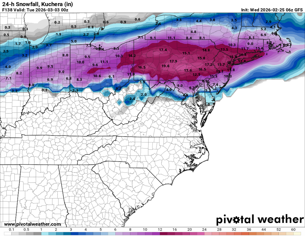
GFS is just pure SEX -
E PA/NJ/DE Winter 2025-26 Obs/Discussion
Duca892 replied to LVblizzard's topic in Philadelphia Region
Fun to have maybe one last SECS/MECS to track at least for now. 6z GFS rolls in 10 -
E PA/NJ/DE Winter 2025-26 Obs/Discussion
Duca892 replied to LVblizzard's topic in Philadelphia Region
Ralph you think the Monday/Tuesday system has a real shot? Would love one last Winter Storm Warning -
E PA/NJ/DE Winter 2025-26 Obs/Discussion
Duca892 replied to LVblizzard's topic in Philadelphia Region
GFS has Thursday System, 3/2-3/3 System, and then follows it up with a quick hitter on 3/4 lmfao. Give me a nice warning level snow to close out the year and we can move onto Spring -
E PA/NJ/DE Winter 2025-26 Obs/Discussion
Duca892 replied to LVblizzard's topic in Philadelphia Region
This place is going to be popping if this chance for early next week is here at 12z tomorrow. -
E PA/NJ/DE Winter 2025-26 Obs/Discussion
Duca892 replied to LVblizzard's topic in Philadelphia Region
Still there next week. Moved more North so definitely warmer, but if that low is about 50-75mi south it would be a paste job -
E PA/NJ/DE Winter 2025-26 Obs/Discussion
Duca892 replied to LVblizzard's topic in Philadelphia Region
18z GFS brings the Thursday Night quick hitter back north