

Duca892
-
Posts
704 -
Joined
-
Last visited
Content Type
Profiles
Blogs
Forums
American Weather
Media Demo
Store
Gallery
Everything posted by Duca892
-
I was saying it this morning and unless it loses it i will say it again The GFS for this storm was the NAM for Jonas in Jan 2016. The NAM absolutely locked in on that storm and then every model trended towards it. Same thing has happened with the GFS.
-
Waiting... for... King GFS.
-
I was just telling my mom that I think 3-5in is a really good call right now for Lehigh and I am suspecting that we end up with a Winter Weather Advisory when all is said and done for that exactly. Lolipops of course of localized 6-7in in spots, but I really like 3-5in for those areas.
-
Annnnnnd Winter Storm Watches are up and live folks!
-
I feel pretty ok throwing my hat in the ring for a 3-5in snowfall for places like Allentown, Bethlehem, Whitehall etc. Just taking all solutions into account.
-
Sorry if I am wrong. Isn't this a step back from 6z EUROAI?
-
EURO.... the EURO looms large and I need it damn it... NAM/GFS both give 8-12+ for the entirety of SEPA... EURO... please...
-
GFS Clocking in YET AGAIN with 12in+ SEPA wide
-
Have a meeting from 10:30-11:20, i will judge how the 12z GFS performed by the amount of comments there were
-
The only important thing with the ICON is if it was an improvement over its last run. Which it sounds like it was? Correct me if wrong please
-
Mike Masco just from PIX11 just issued a 1st call with a large swath of 1-3in for SEPA and then 3-5in once you get into Philly and Jersey
-
If the GFS does some crazy shit at this point I will go nuts. Keep being the little engine that could you bastard.
-
That is why I don't see an issue with and I expect a Winter Storm Watch to go up this afternoon. Better to be safe than sorry. Watch can always be downgraded. Even if you just put it in generic terms of "Potential for 6+ inches of snow" and adjust from there accordingly
-
Feb 22nd/23rd "There's no way..." Storm Thread
Duca892 replied to Maestrobjwa's topic in Mid Atlantic
If i had to venture a guess including areas like SE Pennsylvania, Watches will go up either around 12pm or the 4pm update. It is warranted at this point and can always be downgraded especially in the SE PA regions. -
Look how tight that precip gradient is lmfao. 9in in Allentown to 18in 50mi south in Philly.
-
NAM joins the party with 8-12 lolipops of 12in+ closer to in and around Philly. Yea Watches going up this afternoon
-
Weenie me away
-
Letting the run play out but they don't seem too hot about the NAM on the MA Forums
-
12z NAM rolling. Lets see if we can buy a NAM'ing
-
Feb 22nd/23rd "There's no way..." Storm Thread
Duca892 replied to Maestrobjwa's topic in Mid Atlantic
Can a brotha buy a NAM'ing please. -
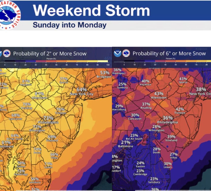
NWS update this morning has most areas at 35% or higher for at least 6in. It’s kind of why I think they will roll a Winter Storm Watch out this afternoon.
-
I don't understand model lines lol. I was always under the impression the 540 line is your freezing line. Is that just completely inaccurate? lol
-
......then what is literally everyone else missing lmfao
-
NAM rolls at 8am?
-
DT now acknowledging he has to change up his forecast just outside of the EURO now.


