
.jpg.2498e782e3b3ce7eeb1160d3454b2ebc.jpg)
Gino27
-
Posts
540 -
Joined
-
Last visited
Content Type
Profiles
Blogs
Forums
American Weather
Media Demo
Store
Gallery
Posts posted by Gino27
-
-
Well I'll be damned
-
1 minute ago, StormfanaticInd said:
 This is starting to get interesting
Reminds me of a surprise 4-5 inches I got ahead of a big NE storm in 2018. High res models were the only ones to pick it up and not until about 36 hours out.
-
 1
1
-
-
-
1 hour ago, StormfanaticInd said:
I feel like the models might be under doing the moisture a little bit
Possibly yeah. Will probably depend on what radar shows the day of honestly. I will have to deal with pretty rough temps and mixing with rain unfortunately.
-
 1
1
-
-
Like @StormfanaticInd said, I'll gladly take this. A a few more ticks west and this ain't bad at all.
-
1
-
-
29 minutes ago, michsnowfreak said:
I am just seeing this picture now. That's amazing. December 2001? Of course big dogs are the best, but if you have to choose between a steady diet of small and medium dogs every Winter versus a big dog every several years with potentially very little snow in between, consistency wins for me. My biggest dog is my favorite storm even though it was not the most ferocious or blizzardy of storms I've experienced. Your climate is great because you get the big storms from the Lake and sometimes the ocean, but you also get all the small and medium sized storms we get. Only downfall is your thaw/torch potential cutting down on snowpack. You may even make a C- on beavis scale lol
Could be my climate where I get small dogs at the consistency of big dogs. Coming up on 10 years since my last 10+.
-
1
-
 1
1
-
-
16 minutes ago, StormfanaticInd said:
Sometimes we do good in transfer situations
With something like this I'd much rather be where you are. Lots of these systems leave a dead zone from about I-71 to Pittsburgh.
-
2 hours ago, StormfanaticInd said:
I think my area might be able to squeeze out 2-3in of snow before the transfer to the coast
I will likely get screwed by the transfer and only pick up a dusting. Unless of course there's a big time trend either east, or west in which I get the edge of the main event or the pre-transfer.
-
GFS ensembles continue to slowly tick west with the big NE storm next week. I might be able to sneak in a few inches.
-
1
-
-
28 minutes ago, StormfanaticInd said:
Storm next week has my attention
Mine too. Would love to see it slow down a bit before becoming a coastal.
-
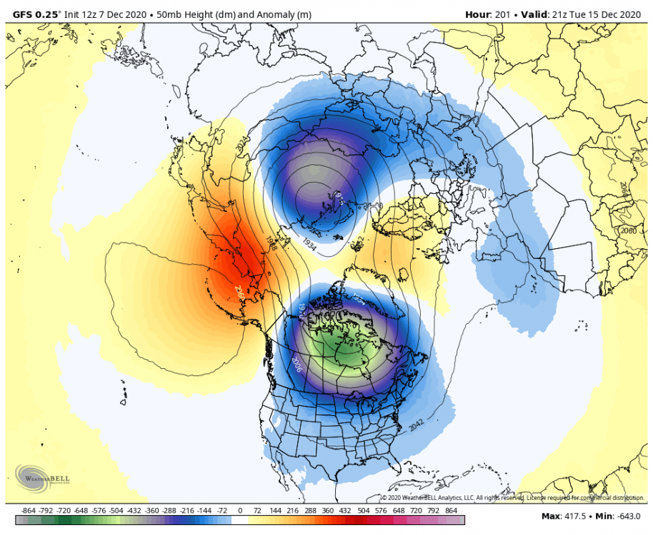
I mentioned earlier that big changes in the strat like SSW's that seem to always be pushed back by models aren't valid. GFS actually bumped this up a day. Will have to see what the euro and ensembles do. Certainly something to watch out for.
-
1
-
1
-
-
1 hour ago, pondo1000 said:
Does anyone have the count on how many frickin times we have seen a sudden stratospheric warming event modeled that NEVER comes to fruition?
Big thing to watch is if the models keep moving the goal posts with them. If a SSW keeps showing up at the end of the run, it's not valid. If it gets closer as time goes on, it might be legit.
-
2
-
-
8 minutes ago, StormfanaticInd said:
Coming close to throwing in the towel on December
Far from over. Seems like most guidance is garbage outside of 5 days. Each signal has a chance.
-
2
-
-
-
Rain/snow mix here in plain city. My station is reading 33.6 degrees when I was supposed to be around 38. Probably from the dousing of cold rain overnight.
-
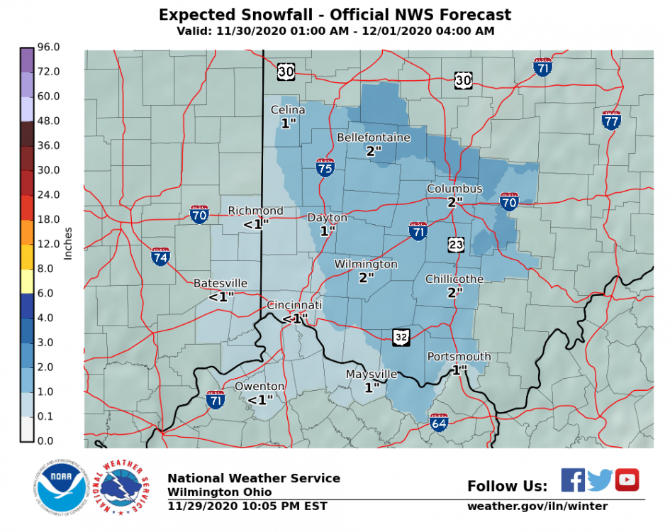
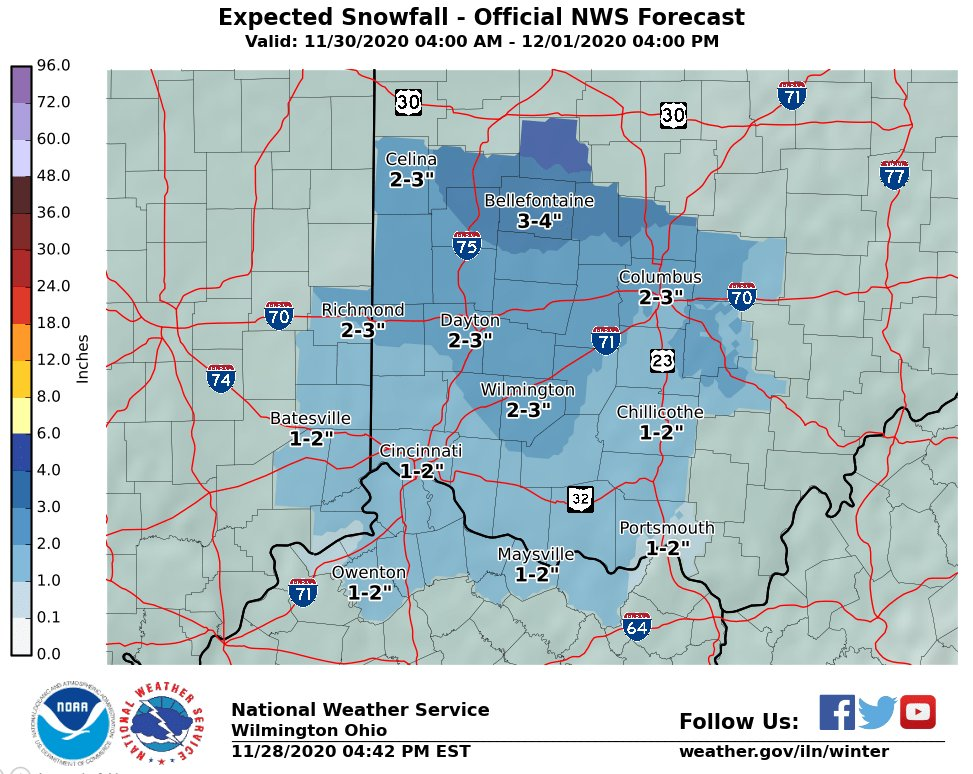
I still don’t get why ILN is only wanting to make maps for part of the storm, and going a bit low while doing so. -
ILN still going very conservative. WWA for 2-4 inches even north of Bellefontaine, which they have a forecast of 3-7 for.
-
48 minutes ago, nwohweather said:
Rant incoming.
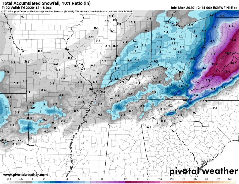
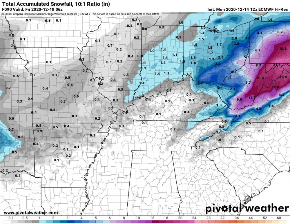
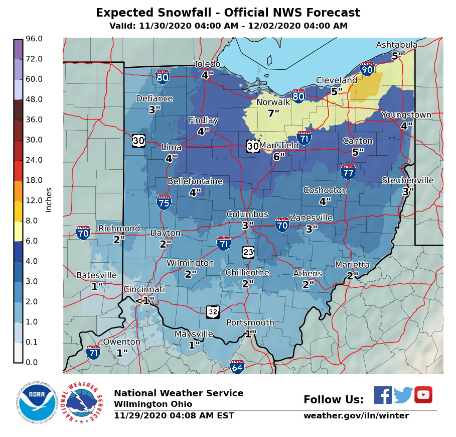
This map is so infuriating. Clearly IWX shows 6”+ for the Toledo area, yet CLE has them around 2-4” as do the local Toledo mets.
It’s like the local people in Toledo are obsessed with American models, so when the Euro consistently shows an amount on either side of the coin they don’t cling to it until 12 hours beforeThe difference between the offices is pretty astonishing.

ILN put this "all of ohio" map out this morning, which is usually a mashup of ILN, IWX, RLX, PBZ and CLE. However, it's really obvious that
IWX and CLE have much higher amounts for areas like Findlay and Toledo, along with slightly higher down towards Columbus. I'm sure they will iron these out today, but it's odd to see one office suggesting winter storm watches for an area while one county over an office think 3" max.
-
3 minutes ago, Snownado said:
Is this consistent with most of the models ? It seems to me like most models are showing a bit more than this ?
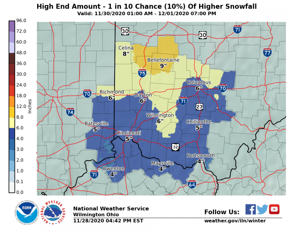
Definitely going conservative for now. I'm assuming they have the same low confidence as I do lol.
-
1
-
-
34 minutes ago, Snownado said:
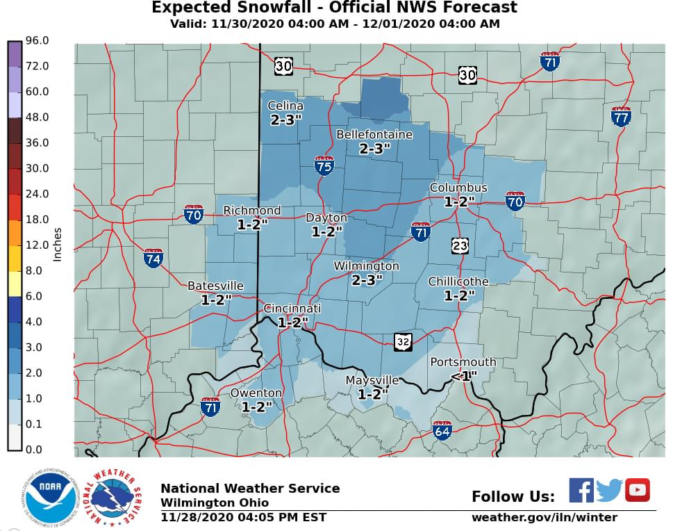
That's kind of deceiving then. Why not just issue a forecast for the entire 2 rounds instead of just for 1 round ?

They just updated it to include the rest of Tuesday. This is either conservative, or genius. Time will tell.
-
9 minutes ago, CoachLB said:

ILN is also forecasting this as a two round system. There would still be a few more inches across the board after 4am.
-
2 minutes ago, CoachLB said:
NWS Wilmington always slow draw and conservative.
They love to bump up totals about 12 before onset. I’m really interested to see how much weight they give the gfs given that the other models are near warning levels for northern counties.
-
19 minutes ago, vpbob21 said:
Yeah I think Bellefontaine would be a great place to be in this setup. I think that area was the jackpot zone when Sandy came through here a few years ago.
I second this. Bellefontaine also has about 500ft of higher elevation so they may have less issues with accum.
-
2
-
-
5 hours ago, nwohweather said:
Makes you wonder if some places will be issued Blizzard Warnings. At the heart of the storm in that main band consistent 30-35 mph seems attainable with heavy snowOur offices around here tend to be extremely conservative in regards to blizzard warnings. Big storm in January 2019 had conditions like what is expected for over 6 hours and ILN just did a WSW and mentioned blizzard conditions.


Winter 2020-21 Medium/Long Range Discussion
in Lakes/Ohio Valley
Posted
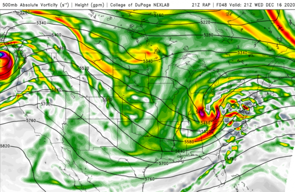
Sorry ¯\_(ツ)_/¯ ... I still don't like the way it has that gap between western and eastern ohio. Keeps looking better on vort and euro had a similar look. Might be a sneaky good system.