
.jpg.2498e782e3b3ce7eeb1160d3454b2ebc.jpg)
Gino27
-
Posts
540 -
Joined
-
Last visited
Content Type
Profiles
Blogs
Forums
American Weather
Media Demo
Store
Gallery
Posts posted by Gino27
-
-
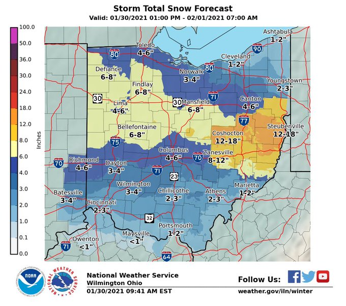
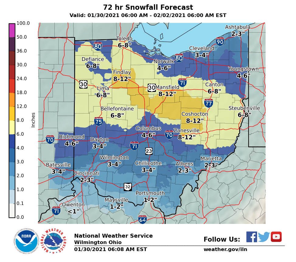
I'm hearing that they got over 8" in Marion and 10.5" up in Mansfield. Sure would've been nice to not have any mixing.
-
Just now, pondo1000 said:
Diddly here. Enjoy the “reach around”!
Deform might try and do something during the day tomorrow. Other than that I think I'm calling this one finished. About 7" total fell but with poor ratios, melting and compaction, I will probably wake up to around 5" on the ground again.
-
I'll end up around 7" for the month of January. December was definitely a much better month but still ending on a high note. It's nice to not be 20" in the hole on an average season for once.
-
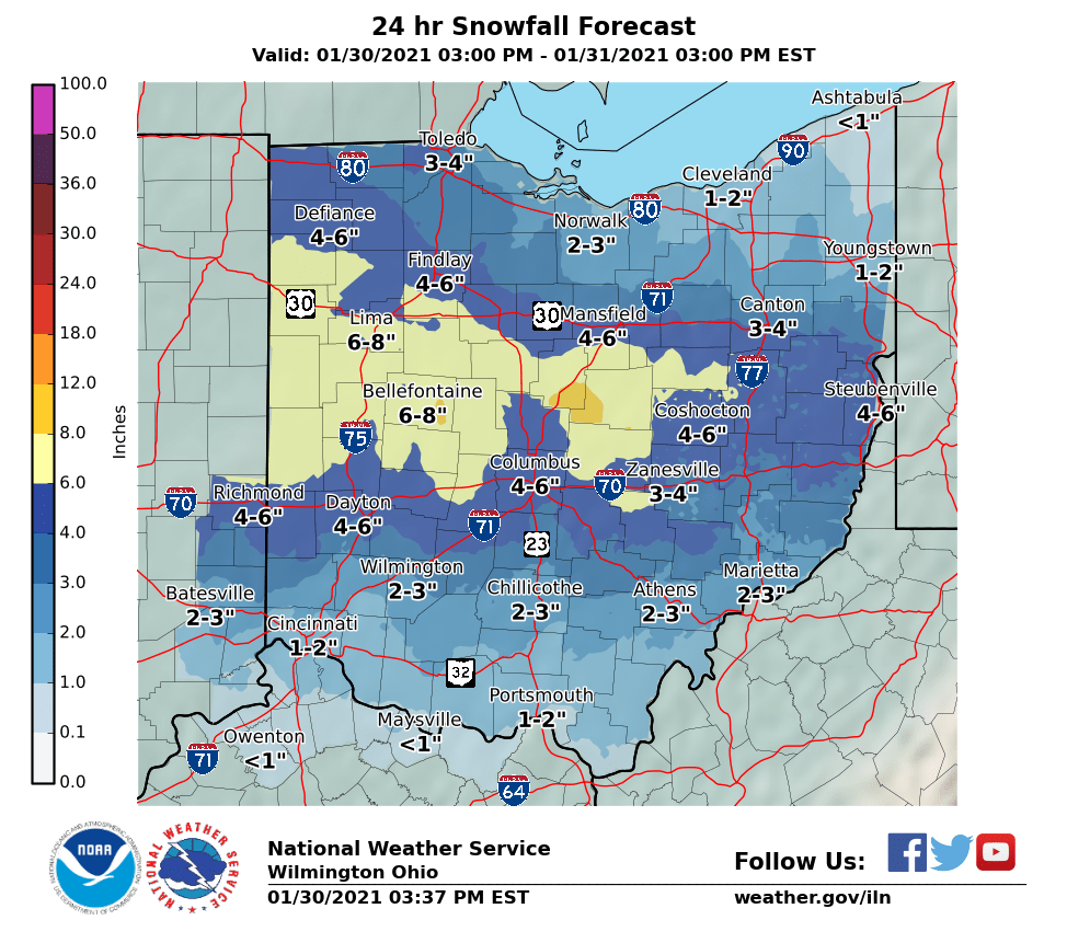
I've been snow for about 1.5 hours. Just now starting to stick on the driveway again. The rest of the snow doesn't look too impressive though.
-
I measured 5” this morning north of plain city. Had about an hour or two of snow and now sleet. Looks like I might avoid pure rain before going to snow. I think 2-3 is possible on the back end of this because ratios should improve.
-
45 minutes ago, osubrett2 said:
There are still pockets of warm air aloft that caused mixing around Dayton and now around Columbus. These pockets will cool completely overnight and moisture near CVG will move this way as snow. 850s shouldn't rise above 0C until 9-10am. That's when our risk of rain and melting starts.
Yep. I'm already back to snow. Hopefully it holds up through the morning.
-
Had some sleet. Now nothing. Kinda nervous because we only get warmer from here.
-
I've gone sleet NW of Columbus. Warm tongue of death doing it's thing here.
-
Absolutely ripping. Enjoy this one!
-
Absolutely dumping here. Thundersnow to my SW.
-
Battled virga for about 45 mins but am snow now!
-

There's something going on with the Delaware county borders. First the NWS snow map had a 4" difference at the border, and now the HRRR back that up with some very defined temp contours. lol
edit: why is the pic so small

-
8 minutes ago, Jim Martin said:
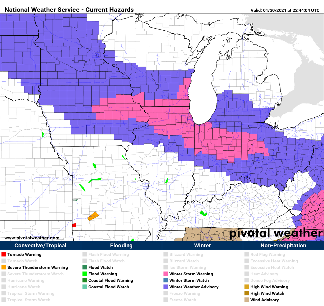
Winter Storm Warning for Hardin, Auglaize, Mercer, Darke, Shelby, and Logan County Gino.
Union County (where I live) is on there too. Knox, Delaware, Marion, Licking... should be in the warning too at least in my opinion.
-
I'm still baffled that CLE and ILN didn't update some of their counties to a WSW. They have my county in a warning but are leaving some areas near mine that are forecast to get more in an advisory for 3-5.
-
 1
1
-
-
This could still evolve in a few different ways so I went with a pretty broad 5"-8" range from a bit south of I-70 and onward north in my twitter forecast.
-
I had thundersnow not that long ago during the 2/20/19 WAA event.
-
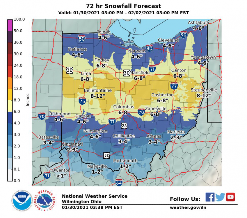

ILN must really hate Delaware county. They’ve got their 4-6 up against CLE’s 8-12 through 24 hours. I’m kinda shocked that they only have have an advisory for 3-5 outside of these counties:

-
2 hours ago, fyrfyter said:
I hope you’re right, I’m just not too optimistic on that. I know every model does a poor job with the WAA.
This is 100% the reason why ILN and I are staying low. January 19th 2019 is a prime example.
-
1
-
-
Someone is wrong... I don't know who.
-
 1
1
-
-
2 hours ago, Stevo6899 said:
Can you please share the link to this website. Ive seen these kinda days since warnings maps used for severe weather. Something like 2000 days since a tornado watch in detroit i think lol. Thanks.
https://mesonet.agron.iastate.edu/plotting/auto/?q=92
Here you go! There's a lot of things to play around with so enjoy.
-
1
-
-
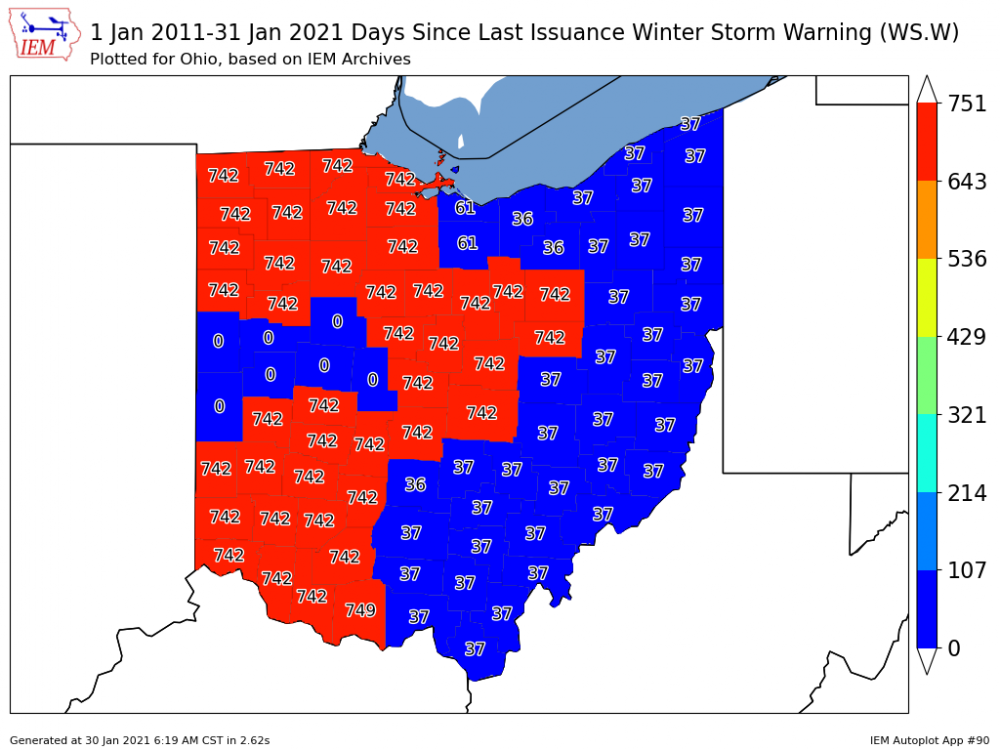
I feel like I've made out like a bandit in Union county. Clock keeps ticking for most of the state.
-
2
-
-
If you look reaaaaally close you can see the WFO borders lol. I'm surprised that ILN left Delaware county and that CLE left their southern counties out of their warning.

-
So much boom and bust potential here with the unpredictability of the warm tongue. I feel for the NWS.
-
2
-
-
Since it seems like ohio folks around I-70 will switch over to rain for a few hours after getting 3-5 inches of snow, I wonder if a decent about of that will melt before going back to snow.


“Let’s Talk Winter!
in Lakes/Ohio Valley
Posted
This could definitely be a nice stretch of winter like many of us have been craving. Some high ratio snows would be nice compared to the "warm tongue" of death slush crap we've been getting.