

Gino27
-
Posts
550 -
Joined
-
Last visited
Content Type
Profiles
Blogs
Forums
American Weather
Media Demo
Store
Gallery
Posts posted by Gino27
-
-
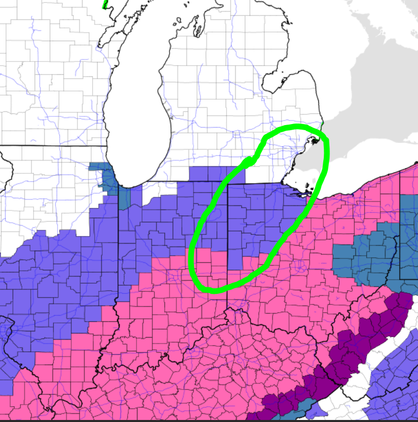
Man this thing is screaming NW. I went from being on the NW fringe of heavier snow to almost a mix in just 12 hours of runs. Hopefully just windshield wiper effect here.
-
Just now, fyrfyter said:
Is that Northern IN or fringe of ILN CWA? I know the criteria is different the further North you go.
It's both northern IN, ILN, and CLE. From what I've read so far is ILN is treating this as a two part storm and they don't think those areas will reach warning criteria from either wave, despite ending up with 8" overall.
-

Classic lowball advisory calling for 5"-7" here. NWS must not be buying the NW bumps yet. Even though I'm in a warning, I feel like areas to my NW will out perform.
-
Well everyone. It's finally upon us.
-
11 minutes ago, Malacka11 said:
For all of you who have been deserving this snow for a while, I hope it delivers and then some.
I like nice people
-
 1
1
-
-
21 minutes ago, Jim Martin said:
CLE finally issued Winter Storm Watches, but not for NW Ohio. Not exactly I buy that either.
CLE and ILN are really hugging the further east idea that’s the gfs and others had. I understand they consider a lot more than just models but it’s kinda appalling given that the more eastern models aren’t even initializing the high pressure correctly.
-
1
-
-
This is just crazy...
-
Models seem to be overdoing the heights that push the storm east compared meso analysis. I wonder if the SE trend over the last 24 hours is really legit.
-
Just now, jbcmh81 said:
March 2008 was such a great, long-duration event. However, it's not exactly been 13 years for all of Central Ohio. February 5-6, 2010 saw 12"-15" for some areas along and north of I-70, and February 15-16, 2010 hit a foot in a few spots. Double-digit snowfalls are exceedingly rare in Central Ohio, though. If we go by single-day totals, there have only been 3 since 1884. 2-day events, you only have 10. So this event could be historic from that perspective.
How could I forget Feb 2010! Ugh what storms those two were.
-
The SE joggle on the majority of models has been a bit concerning. Still not worried because this should drop a fairly wide swath of snow, so being outside the jackpot won't be a big deal.
-
ILN AFD:
However, some important differences remain in low placement and
intensity. The 00Z GFS is running faster and a bit further
south while the ECMWF is slower, stronger, and further north.
Due to these differences, have continued a rather broad band of
4-8 inches area wide. Certainly there is a good possibility
local areas will see nearly a foot of snow with higher drifts
based on QPF, snow ratios, duration of the event, and wind
fields. In addition, as the low reaches the vicinity of the
central Appalachians, some forecast soundings -- particularly
the 00Z GFS -- show a deep saturated layer centered in the DGZ.
Will closely monitor track and strength of the low, as these
will play a critical role in a detailed accumulation forecast
leading up to the event.
Central Ohio hasn't had a foot from a single storm in 13 years. Wow.
-
2 hours ago, vpbob21 said:
18" right on top of my location? Easy toss.
I see myself dead center of the 15+ band. lol
-
3 minutes ago, pondo1000 said:
We are all weenies and all been burned and all been bummed. It’s why we are even on this stupid board! LOL
Exactly haha! I do miss the days when I didn't really track snow events and snow was a surprise, but there's nothing like watching a storm come together on models and verifying
-
1
-
-
7 minutes ago, pondo1000 said:
You win the prize for most pessimistic! LOL Understandable though!
Half sarcasm, half realistic I guess. Being a weenie has gotten me burned so many times lol. I can't lie I'm getting really excited for this setup just as I was for the last storm. We've sure had some putters out of good setup before, but I'm even seeing some '08 similarities (minus the deform blizzard part).
-
20 minutes ago, blue60007 said:
12z GFS with strong support from GEFS for a solid hit across much of IN and OH. GEFS seems a tad further NW of the op with the heaviest stripe. Looking solid for those of along and south of I-70. The extended range of the NAM supports a GFS solution as well.
Looks too good to be true given the way these had evolved over the past 5 years. There's always going to be a catch that shows up in the short range (dry air, mixing, shunt in track etc...)
-
2 hours ago, NoDoppler4TnySandz said:
ILN always plays it that way this far out...the fact that we are still 60+ hours out and they are referencing a few inches is somewhat significant IMO.
A couple of the local mets down here (TV 12 and 19) that I trust as a Met and not just a reader of the tele-prompter were both talking about essentially wintry precip Monday into Tues, Weds, Thur-Fri --- Now I know why the school district sent an email last night saying to make sure the kids had all needed material for online days in case it was needed...My guess is the potential of next week has been shared with the Superintendents.
In the near term...the Saturday system is not that far SE from the I-71 line....if that ends up slightly NW, what is the ripple effect downstream through the week? Perhaps that's the NW tick that the Chicago and Mich crew would like to see? Just thinking out loud.
Yeah ILN lowballs everything and ends up right 90% of the time. Of course we can't guarantee the track of the storm given the system out ahead of it. However the Mon/Tue system should be widespread enough that along I-71 should be somewhat safe, other than the fear of mixing like the euro put out last night. The warm tongue around 850mb means business.
-
From ILN's AFD:
Heading into Sunday night and Monday, guidance is beginning to show
shortwave activity ejecting out of the central U.S. trough. This
induces weak isentropic lift Sunday night into Monday morning, so
PoPs have been introduced. Thermal profiles look to support mainly
light snow, with some light freezing rain and sleet mixing in for
northeast Kentucky potentially up into the lower Scioto River
valley. NBM thermal fields appear too cold aloft, so blended in NAM
and CONSALL data.
After a brief respite Monday afternoon, the next disturbance arrives
from the southwest Monday night into Tuesday. Once again, snow
should be the main precipitation type. Wouldn`t be surprised to see
a few inches from this system -- though uncertainly remains high on
track/intensity of low pressure. Once again, warm air aloft could
mean some sleet/freezing rain in the southeast.
I didn't know we were just looking at a "few inches"
-
1
-
-
Well now most models are in somewhat of agreement over the OHV. Time for a mega trend to the coast!
-
 1
1
-
-
20 minutes ago, zinski1990 said:
GFS progressive bias in mid range. Always happens it seems
I know it usually does this, but it still worries me on the chance it's being the 1st to catch on to a trend.
-
3 minutes ago, CoachLB said:
18z gfs going fishing in the Gulf of Mexico.
Could be typical progressive bias from GFS or another one swept out from under us. Time will tell.
-
Each run is just weaker and weaker. Idk if this one will survive tbh.
-
1
-
-
Looks like it's still holding as a decent storm for the OHV. I doubted a big dog from the start, but ratios could be on my side.
-
2
-
-
This is kinda sad lol. Maybe it'll rebound
-
I feel a real "polished turd" storm at best. These threats just don't stand the test of time anymore.
February 14-16 Winter Storm
in Lakes/Ohio Valley
Posted