
.jpg.2498e782e3b3ce7eeb1160d3454b2ebc.jpg)
Gino27
-
Posts
540 -
Joined
-
Last visited
Content Type
Profiles
Blogs
Forums
American Weather
Media Demo
Store
Gallery
Posts posted by Gino27
-
-
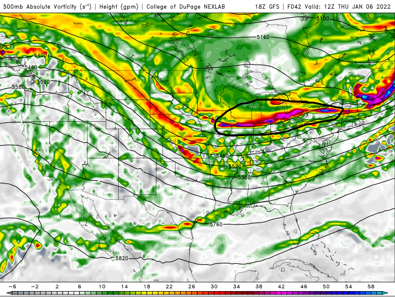
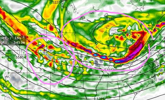
Confluence is in the absolute worst possible spot and much stronger on the 18z GFS.
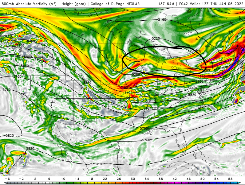
The look that the NAM gave is pretty much our only hope.
-
40 minutes ago, iluvsnow said:
This annual winter thread started October 3rd and remained at one page through all of December. In four days we add four pages....and zip to show for it. Winter in the OV

We're always hosed by NW trend, or the lack there of. It must just be our climo/geography.
-
We made it under 100 hours before slipping away this time! That's major progress!
-
 1
1
-
-
3 minutes ago, buckeye said:
Yep, big red flag. Really the only good run so far has been the nam +60 hrs. Not encouraging.
GEM trended weaker and south, icon is nada, gfs is nada, ukmet was showing hope at 00z but it went back to crap at 12z. If I were a betting man I'd have to put my chips on the euro starting to cave at 12z. If not, then we can at least hug the ole EE rule.
Regardless,after that it's a rainstorm followed by a sharp cold front that is transient. In this wavy pattern it's all about luck and timing. DC has the hot ticket right now.
For what it's worth, the storm that's pounding the Mid-Atlantic followed a pretty significant NW trend within 90 hours. But the setups just aren't comparable. Within the last 24 hours the GEM and UKMET have gone back and forth a lot and the Euro has been most consistent, so we at least have that.
-
GFS has been shifting towards the Euro in terms of handing the first wave, but I fear the Euro has been over-amplifying the second wave. CMC might've just taken a huge step towards what the GFS has been showing.
-
GFS keeps ticking slightly better on 500 vort, but looks the same if not worse overall.
-
Euro coming in with more of the same. Getting closer folks.
-
GFS took a step towards the better solutions for us. Still need a lot of work, and everything else has to hold serve
-
1 minute ago, snowlover2 said:
GFS still looking like hot garbage.
Yeah it’s another gfs vs. everything model extravaganza. With how much the mid-Atlantic system changed within the last 48 hours we’ll see how things settle by Tuesday or so.
-
1 hour ago, snowlover2 said:
Temps stay in the teens the whole time in Ohio.
Same look on the euro. Still we track…
-
27 minutes ago, Spartman said:
Still not good, though. Won't be long until we keep kicking the can again after coming out of one of the least snowiest Decembers ever. We'd hate to go for one of the least snowiest Januaries next.
Might happen. OOZ gfs erased any progress. First wave of energy sticks around forever and suppresses the daylights out of our signal. Extra frustrating given how close this is to being SOMETHING in this dismal winter.
-
We need some separation between waves. The better runs has that first bit of energy well out of the way and not suppressing the one we’re interested in
-
Dropped again. This thing is a real headache lol
-
6 minutes ago, snowlover2 said:
Appears 0z Euro will still have it.
I love the way it looks on 500 vort, but I'm afraid it took a step toward CMC and GFS
-
I'm afraid we got the ol 150 hour headfake
-
Most of us are in a good spot between the spread of Euro/EPS and GFS/GEFS given their typical biases. Modeling has still be terrible outside of 84 hours so I expect big changes still
-
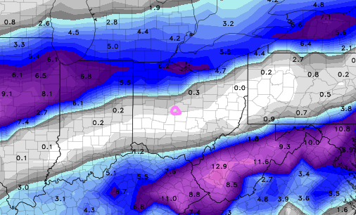
Euro comes way NW and puts the mix line on the wrong side of I-71 for a lot of us. Not sure if it's an amped bias or if we're in for another rainer.
-
Looks like the 2/15 sleet storm from last February. Still a long way to go.
-
11 minutes ago, Spartman said:
Not to mention less cold on that run.
It brought it back but with very different timing. Hard to believe what it's doing given the big system ahead of it. It is nice to see euro support from 12z however.
-
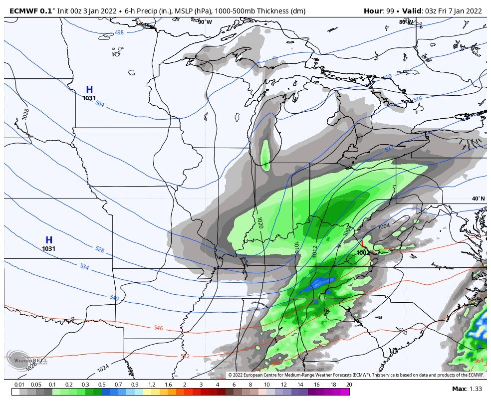
Models have a few things to be looking forward to in the medium range time: breaking down of the SE ridge, multiple waves of energy coming across to the east, and cold air in place. Thing is we're still gonna have to thread the needs to get snow imo.
-
Heh...
-
1
-
 1
1
-
-
What is a snow?
-
 1
1
-
-
On 12/4/2021 at 4:32 PM, jaf316 said:
Gfs and euro both give central OH a light frosting on Tuesday night. Maybe an inch or so. Not much, but I'll take it...
Sure looks like we could see a widespread dusting or maybe an inch. Ratios will be on our side but dry air will be hard to overcome.
-
Snowed fairly hard here at OSU. Had a coating on the grass but melted quickly. Loved the mood flakes!

“Let’s Talk Winter”
in Lakes/Ohio Valley
Posted
I've been seeing some NW ticks on the models. We just going to get enough curl on vort before the coast robs our energy, and the confluence is still going to squash everything. It is a shame, but long range doesn't look as bleak as it once did.