
.jpg.2498e782e3b3ce7eeb1160d3454b2ebc.jpg)
Gino27
-
Posts
540 -
Joined
-
Last visited
Content Type
Profiles
Blogs
Forums
American Weather
Media Demo
Store
Gallery
Posts posted by Gino27
-
-
9 minutes ago, CoachLB said:
I think we will see this track SE next couple days.
A lot of mets are thinking the same thing. If it trends SE and keeps the same strength...watch out
-
 1
1
-
-
This is so close to being a huge hit for a lot of us on this board. Would be nice for Columbus to break it's streak of no storms over 6" dating back 2015.
-
 1
1
-
-
11 minutes ago, jbcmh81 said:
Climo would support a further west track, though. There's a reason Ohio tends not to get its biggest storms until January or even February.
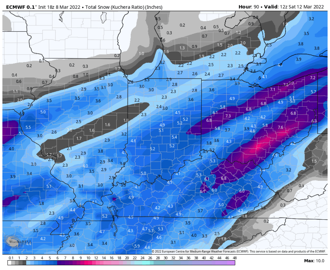
Well to be fair, climo does not support a storm bombing out over Indianapolis by any means so the result would likely be a bit east.

Regardless a pretty good hit on euro, although likely overdone. Will be very impactful no matter the outcome.
-
32 minutes ago, buckeye said:
126 hr gefs…. Not exactly a set in stone track. Very dynamic system and doubtful exact track is nailed down outside of 72 hrs. Whatever happens this is a fun one to track.
GEFS is pretty much exactly what we want to see at this range. Tons of moving parts and climo tells me this can’t go too much further west than overnight euro and gfs had it.
-
25 minutes ago, CoachLB said:
wind shear will hurt ratio. i will take what i can get. better than brown and frozen.
Even the worst wind shear isn't going to be worse than 10:1. Still hurts our chances of seeing super efficient ratios though.
-
-
25 minutes ago, Buckeye1994 said:
Dayton and Columbus Ohio are again begging for a shift eastward… if not another cold rain followed by a back side tease of wind driven 2-3 inches
I think we could get a lot more than 2-3 inches even with the current track. Ratios will be extremely efficient and an occluded low in that position can pull from Lake Michigan.
-
1
-
-
I’ve got to assume GFS will keep going west and end up in line with other guidance. Question will be whether it’s windshield wiper effect over the next 3-5 days or if this thing goes west enough to be a Rainer for us.
-
Nice -
23 minutes ago, pondo1000 said:
Anyone see the Euro yet & the loopy loop it does? LOL
Not sure pattern supports it, but the latest trends with PNA and NAO could bring it more west like that.
-
Even with the worst solutions being CMC and ICON, we would still pull a white Christmas out of those. Really hoping we're still tracking this thing under 100 hours.
-
Big difference with the GFS and Euro is that the Euro has a coastal low which doesn't let the wave dig from the NW, therefore we are warm and rainy
-
I'm not giving that threat any attention for a few days
-
There's something of a signal around the 19-20th, but suppression just rips it apart.
-
On 11/12/2022 at 11:46 PM, Spartman said:
At least we didn't have to wait until February for the first 1+" snow like last Winter.
Still haven't had anything near Columbus, but I think that changes this week.
-
Warm nose. Sleet-fest. 33 and rain. Bring it
-
1
-
 3
3
-
-

I-71 flexing
-
1
-
-
Columbus has been pretty lucky with avoiding ice storms recently. Not sure our luck will keep going this week.
-
2 hours ago, buckeye said:
Nice pics. I'll be kind and not bump those first few posts from you and pondo yesterday morning

So now it's time for the post tracking blues made worse by an extended that has nothing but cold and dry for the next 10 days. I hear JB says winter dies in 3 weeks. If he's saying it, it's probably a good bet since he never forecasts winter's end this early. I'm ok with that, AS LONG AS WE GO ABOVE NORMAL TEMPS. CAD in late Feb into spring is miserable.
Was just talking to some people about this very thing. Maybe we squeeze one more storm in during this upcoming cold and dry pattern, plus a clipper or two, but overall things look to heading towards winter wrapping up. I’m sure we’ll see some nuisance snows in spring but I’ve been killing for a decent stretch of severe weather.
-
4 minutes ago, dilly84 said:
Some 2"/hr stuff coming through cmh now.
All the heavy returns are sleet. Looks like the lighter bands are actually producing the accumulating snow
-
Looks like another dry slot after this bout of sleet. That could further warm us up. Ugh
-
Back to snow for now. Looks like pockets of sleet around for a bit longer
Edit: back to sleet. I need to distract myself for the next hour lol
-
This sleet is rather frustrating. Just keeps building back in
-
I'm not concerned about this bout of sleet. We changed over to snow way earlier than I expected, and i think most of Columbus is back to snow by 7:30-8:00. Also radar returns to our SW look awesome and we should be ripping now once we change back.

Let’s talk weather!
in Lakes/Ohio Valley
Posted
From the synopsis’ I’ve read. They mostly gave up on measuring because the drifting was so bad that there was no accurate way to measure even with averaging.