
.jpg.2498e782e3b3ce7eeb1160d3454b2ebc.jpg)
Gino27
-
Posts
540 -
Joined
-
Last visited
Content Type
Profiles
Blogs
Forums
American Weather
Media Demo
Store
Gallery
Posts posted by Gino27
-
-
For what it's worth, the GFS tries to bring in some pretty big cold after the 10th. Is it drunk?
-
12 minutes ago, Snowstorms said:
+ENSO and +IOD forcing playing a role in that. As well, models are hinting at the MJO trekking its way into phases 2-3 near mid-December which translates to a warmer pattern for us. Going to have to see if the upcoming -NAO/AO can hold on a bit longer. In recent years, Atlantic blocking has been abysmal so it wouldn't surprise me if it breaks down quickly.
Regardless, the cooler anomalies in the first week of December won't be anything insane. Without proper blocking, it'll most likely be transient cold.
Ugh. These early season teases really set me up for disappointment in December. Hopefully any mild stretch is short lived. Last year's went for like 5 or 6 weeks. Wasn't it a raging pacific jet that killed us? Are there any signs of something like that for this year?
-
2 hours ago, Angrysummons said:
The upstream is in bad shape right now. You need to be patient. Decembers generally in this type of pattern setup, generally aren't very good.
It also breaks my heart to see plenty of cold air without a favorable pattern. I know it's very early but still...
-
 1
1
-
-
What does everyone think of the pattern heading into December? As of now it looks as if it will certainly be cold, but I don't like the way the storms are tracking atm.
-
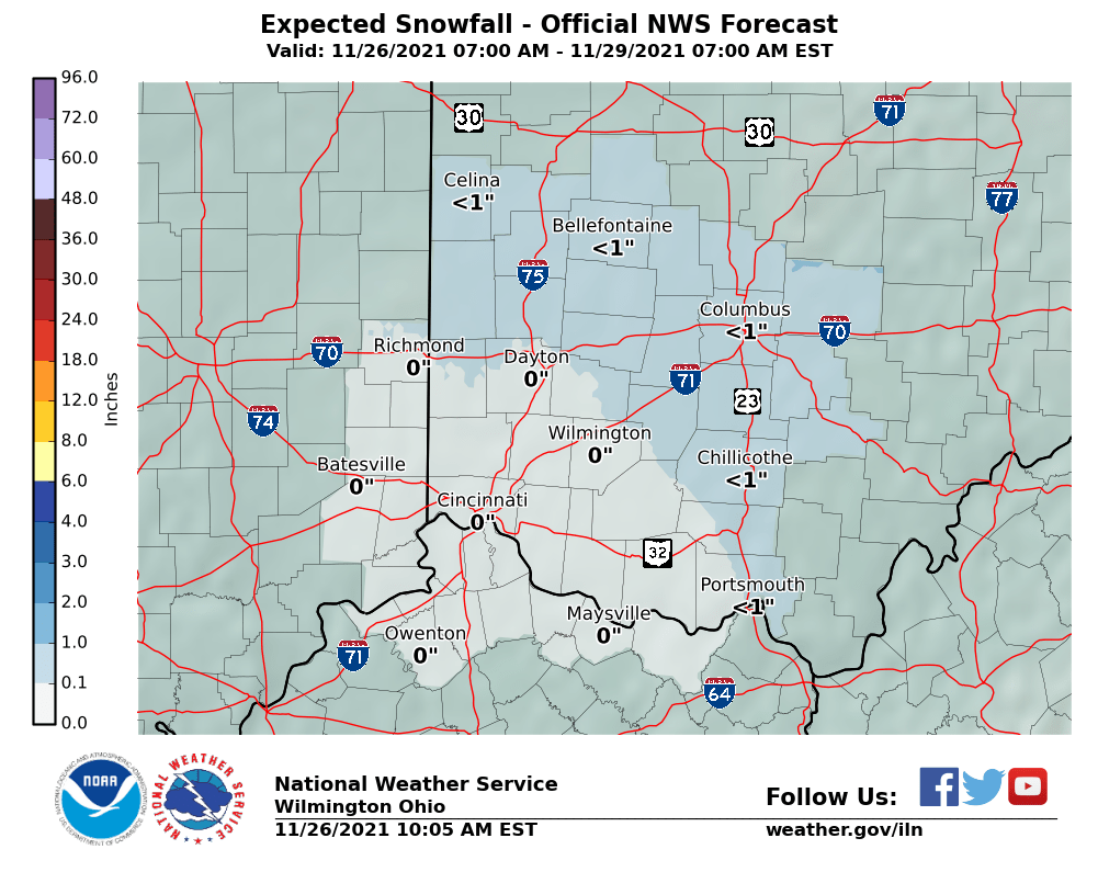
NWS Wilmington is starting to crank up the totals.
-
Looks like another I-70 / I-71 battleground here in Ohio until it becomes all snow.
-
I think things are trending in the right direction for my area!
-
GFS is in full windshield wiper mode now.
-
Just now, Jim Martin said:
The NAM just being the NAM...
I figured. My hope is that this thing can get its act together and lay some nice snow down for Central OH.
-
Not really sure what the NAM just put out... looks like nothing for pretty much most of the Midwest except for lake effect areas.
-
1
-
-
I'm hoping the cold air makes a stronger appearance. Even though its early in the season, It always breaks my heart to see Central OH go all rain every time.
-
1 hour ago, jbcmh81 said:
Regardless of any snow threats, this week after Wednesday and into next week is looking pretty cold through at least mid-month.
For Columbus, here were the coldest November 1-15 periods.
Top 10 Coldest Average High: 1976: 43.5, 1967/1997: 44.7, 1996: 44.9, 1991: 45.1, 1910: 45.4, 1894: 45.7, 1921: 46.5, 1995: 46.6, 2018: 47.5, 1907: 47.7
Top 10 Coldest Average Low: 1976: 26.3, 1991: 27.2, 1908: 29.8, 1995: 30.2, 1951/1954: 30.9, 1886: 31.1, 1996: 31.3, 1953: 31.4, 1921: 31.9, 1905/1910: 32.3
Top 10 Coldest Mean: 1976: 34.9, 1991: 36.2, 1996: 38.1, 1995: 38.4, 1967: 38.8, 1910: 38.9, 1908: 39.1, 1921: 39.2, 1894/1951: 39.3, 1886: 40.0
Models have been spitting out average means for the first 15 days between 34-37 degrees. There doesn't seem to be any direct correlation to winter as there were both awful and very good winters in these years.
Wasn't the first half of November quite cold last year too? Then we had a pretty chilly first week of December followed by some terrible mild weather for what felt like forever. Hopefully we don't repeat that.
-
Looks like the ECMWF is falling in line with the GFS for next Thursday.
December 2019 Discussion
in Lakes/Ohio Valley
Posted
Unfortunately I think this will be the case for most of December. With MJO likely heading into phases 3 and 4, and +EPO/-PNA it'll be really tough to get any substantial cold in the area. The big question going forward will be the amplitude of the warmth and how long it stick around.