

NorthHillsWx
-
Posts
7,653 -
Joined
-
Last visited
Content Type
Profiles
Blogs
Forums
American Weather
Media Demo
Store
Gallery
Everything posted by NorthHillsWx
-
Finally...
-
Think a lot of people on here are going to like the 18z GFS... and v16...
-
0.74” in rain bucket. 48 and cloudy with mist at the moment. Temps edging closer to 50 but still a huge 24 hour forecast bust
-
These runs set some up for the very rare possibility in the southeast of snow on snow
-
Dew points in teens and temps in 20’s at start time... yea I’m gonna err on the side of cold with that look
-
Lights out indeed. And I believe with that CAD signal the freezing rain would be further south and east than indicated by the models. This has the look of a classic Carolina ice storm. Been a long time since we’ve had a Miller B plus established cold air in place
-
May just have to hop on over to the MA forum to see some reactions to this run
-
Now THAT is how you set the stage for an ice storm
-
That was not the nail in the coffin EURO run many were expecting. This thing officially has legs. Every model has trended better since yesterday or at least stayed the same in CMC and V16’s case. Trying hard not to get at least a little excited
-
Definitely trended in the right direction. Falling in line with other guidance. Dynamics will make or break this storm.
-
Don’t think we’re headed to the mid 60’s as the models had shown as recently as yesterday. Cloudy, misty 46 right now
-
If someone makes a thread after 00z runs it’ll be a day of obs thread. This is going down tomorrow, not 3 days out. That’s what’s shocking about some of the models trending in our favor inside 36 hours from go time. Euro will be telling. But seeing some short range guidance jump on board in addition to gfs and v16 and the Canadian remaining steady, there is a chance this thing pulls the comeback. I know the storm totals on those 10:1 models are way overblown but even a widespread 1-3” storm would be welcome by every member on here in their back yard
-
In any other storm I’d say this has legs. Trending correctly inside 36 hours. In this situation, it’s more of a WTH is happening feeling
-
Canadian has remained fairly consistent. Widespread light accumulation from triad east through triangle. Maybe slightly more in NE N.C.
-
Love how everyone’s held off on starting a thread for it. No one wants to get blamed for another lackluster cold rain
-
Not even close...
-
Strange times these are with model runs... strange times indeed. GFS trends through multiple runs now to a snowy solution, para remains rock solid on its snowstorm solution, and were inside 36 hours. NAM suites say no go and euro says enjoy your token flurries. CMC has had snow most of its runs. Would hate to be a forecaster tomorrow night. Literally could be a localized rate driven 4-5 inches with a forecast of nothing
-
A lot of lightning this morning
-
-
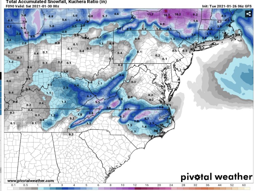
06z GFS brings snow back into central and northeastern NC
-
I don’t think anyone on this board south of VA border expects anything other than token flakes at the moment.
-
Overall trends for ***some**** snow have been positive today. The bleeding has stopped, let’s reel this one back in!
-
I haven’t thrown in the towel for the Wednesday/Thursday system quite yet. The UK/Euro aren’t that far off (too fast) and other models have trended better today (CMC/V16). GFS is warm no doubt but the LP location is good and the storm is still on the models. If we can slow timing down it has a shot. Sure, the big dog storm we saw for several days is gone for good, not happening, odds of a South Carolina National championship in football next season are higher than this becoming a major storm in the southeast, but I think anyone here would take a couple inches of snow. That’s still on the table though not likely. I’ll give it another 24 hrs before I write that off for good
-
I’ll take CMC. Check please! Not exactly the model suites you want to be in your wheelhouse, when opposed to the king and GFS, but hey, at least some models are showing snow in central N.C. again. I’ll take it more seriously if the euro shows improvement at 12z
-
39 with 0.04” for me overnight




