

NorthHillsWx
-
Posts
7,315 -
Joined
-
Last visited
Content Type
Profiles
Blogs
Forums
American Weather
Media Demo
Store
Gallery
Everything posted by NorthHillsWx
-

Hurricane Debby - flooding rain threat region wide
NorthHillsWx replied to olafminesaw's topic in Southeastern States
5.40” here storm total and raining heavily at the moment but looks like a large break upcoming -
Hurricane Debby - flooding rain threat region wide
NorthHillsWx replied to olafminesaw's topic in Southeastern States
Tornado OTG near red oak -
It definitely spun up overnight when it regenerated convection. The dry air that mixed in when it stalled likely saved South Carolina from the catastrophic flooding it otherwise would’ve been capable of producing. Widespread flooding in NC this morning but nothing major yet at least that I’m aware of. I am becoming concerned for the foothill regions that will get upslope enhancement to possibly exceed 10”. This storm has been a prolific tornado producer, and unfortunately one caused a fatality in Wilson county this morning
-
Hurricane Debby - flooding rain threat region wide
NorthHillsWx replied to olafminesaw's topic in Southeastern States
I just read that. Very sad. Looks like another possible brief tornado occurred just east of rocky mount. This is becoming a prolific tornado producer in eastern NC. We’re at 4.65” storm total but 1.55” of that came from the first band in 45 minutes. Not much here yesterday but it’s been a lot of rain today with close to 3” -
Hurricane Debby - flooding rain threat region wide
NorthHillsWx replied to olafminesaw's topic in Southeastern States
-
Hurricane Debby - flooding rain threat region wide
NorthHillsWx replied to olafminesaw's topic in Southeastern States
-
Hurricane Debby - flooding rain threat region wide
NorthHillsWx replied to olafminesaw's topic in Southeastern States
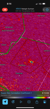
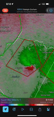
Serious looking debris signature just NE of Louisburg. This one is associated with a very visible hook echo on radar. This probably is a significant tornado -
Hurricane Debby - flooding rain threat region wide
NorthHillsWx replied to olafminesaw's topic in Southeastern States
Likely tornado just south of Rocky Mount Edit: Actually 3 strong signatures showing up in that area. Looks like typical brief spin ups but definitely a few short touchdowns -
Hurricane Debby - flooding rain threat region wide
NorthHillsWx replied to olafminesaw's topic in Southeastern States
Also wind is starting to get cranked a bit. Noticed outages increasing. With the wet soils 30-40 mph gusts will be capable of more of that through the morning. Lots of 30+ gusts showing up right now. Probably won’t be a ton of outages but definitely something that’s affecting us now -
Hurricane Debby - flooding rain threat region wide
NorthHillsWx replied to olafminesaw's topic in Southeastern States
Lots of flash flood warnings and a couple flash flood emergencies this morning. We’re around 4” for the event now. Western piedmont looks locked in for a bad flooding event. Here it may be wherever that tail sets up as Debby pulls north and northeastward. Some areas to the west that get that pivot could exceed 10” (which is what they had forecast here a couple days ago). I think were probably going to end up with 5-6” here which obviously is a significant event but there could be a couple more if that tail sets up overhead -
After picking up 1.55” in about 45 min yesterday we have only picked up 0.09” since. 1.64” storm total so far
-
Nasty tornado with that storm NW of sunset beach based on radar right now
-
I’ve had more than half that in the first 40 minutes of the storm. I’d toss those island GFS runs, it’s already coming back into alignment with other models at 12z. Picked up 1.55” in 40 minutes from the first band. We’ll see what the meat of this thing brings here
-
These tropical downpours are a different species of rain. Picked up 0.20” in minutes from a run of the mill looking shower (on radar) EDIT: It’s a whiteout downpour. Working on 1” of rain in our first 30 minutes with Debby
-
I do agree- Savannah may catch a break here. They are firmly out of the heavy bands and I don’t see this back building over them unless this goes WAY SE. The more northern track probably spared them. Charleston may have a bit of a break after this band passes but there’s no way they don’t keep getting pounded with rain next few days given model consistency there. Being a lot of the city already has 8-14” of rain it seems likely that the 16-20” forecasts there will verify with some areas getting much more. I think the next heavy band that sets up over Charleston could cause the “catastrophic” flooding as the flood situation is already bad there and there’s literally nowhere for the water to go at this point. It’s one band away from reaching that point already.
-
It seems like this may be becoming a bigger deal for piedmont areas in NC. My rainfall forecast has been increased from 5-8” to 8-12” since yesterday. Coastal areas are much better at handling that volume of rain since it’s flat. However, those are hurricane Fran/Floyd type values for inland areas and that’s on top of a lot of rain last two weeks. This could be a bad situation further inland than was thought yesterday
-
Bad take of the day
-
Eastern eyewall is much stronger. Nearly all chaser reports from steinhatchee north are tame. Meanwhile horseshoe beach measuring gusts to 100 and I am sure Suwannee and cross city are getting raked. This thing really came together. Pretty structure this morning, eye clearing out on all satellite loops.
-
Hurricane. Upgrade official
-
Cedar key is taking it on the chin with that very strong eastern band. Those are probably the strongest winds in the entire system
-
FL winds over 90 kts corroborated the radar velocities showing >85 kts in the same band. SFMR values up to 65 kts. I believe we have a hurricane
-
Hurricane has boobies
-
It sucked in the giant pool of dry air that’s been floating around it all evening
-
Recon with 90 kt FL winds in that Eastern band…


