

Stevo6899
-
Posts
2,767 -
Joined
-
Last visited
Content Type
Profiles
Blogs
Forums
American Weather
Media Demo
Store
Gallery
Posts posted by Stevo6899
-
-
2 hours ago, roardog said:
Most people would like a sunny and mild Spring but I would rather have lots of storms with gulf moisture even if it means it’s 40F and raining here while it’s 75F in Toledo. There’s plenty of time for sunny, pleasant and boring days in the summer.
There's plenty of time in the summer for severe storms. Also for low pressures to take the current track of this weekends storm, perfect track for snow but no cold air around. I do see todays euro does try to strengthen the low a bit for maybe some frozen precip. This more wound up solution pulls the baroclinic zone a bit further south for the next storm midweek to take a more southern track and possibly thread the needle for some areas (detroit).
-
1 hour ago, dmc76 said:
Every time I check the models, the cold gets pushed back every 6 to 12 hours every run.
90 days until baseball and possibly/hopefully a warm start to spring.
-
 1
1
-
-
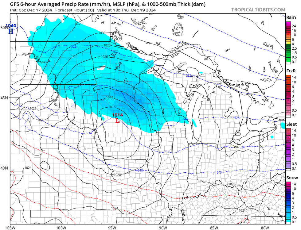
18z gfs might be the sexiest run I've seen in awhile. 3 systems maturing right overhead.
-
2
-
-
3 hours ago, KokomoWX said:
Here is proof that it did snow in December once upon a time.
oh to see those dark greens and yellows on the radar soon this winter...
-
Rain earlier, then sleet,frz rain and now all snow. Roads are a mess, prob an inch of snow
-
1
-
-
Josh, where we at with snow totals so far compared to the last 5 winters. Obviously we've had slow starts recently but I feel like this winter is the most zzzz. Obviously 2019 was a good start. Looking like we're gonna go into the new year with like 3 inches?
-
I'd say 2-3 here. Can't remember the last time the grass was fully snow covered. Had some nice banding to end the event earlier that did a nice paste job on the trees, etc
-
30 minutes ago, Frog Town said:
This is all good stuff...

They basically copy and paste this every year to coincide with the current enso. There's far many more factors in play that make these maps useless.
-
18 minutes ago, michsnowfreak said:
Though the writing was on the wall, disgusted with this one here. A slushy 0.3 of snow imby which melted as it's hovering at 34°. Even though pretty much everyone N and W of me in SE MI had more, it was overall a let down event for most of light wet snow. 4.3" on the season.
It's a shame it ran into confluence. The slow moving nature of the bands makes me feel like this could've been a super clipper, similar to one we got in 2005 I believe.
-
1
-
-
50 minutes ago, buckeye said:
the big one for that was the massive HECS in January that buried the MA and NE, that one threw a slow moving conveyor belt of snow east to west across the state....we almost picked up a foot from that one and it was a complete surprise, even the morning of we were forecasted 1-3"
Obviously not everybody feels the same way but I'm willing to go 5-10 winters (we essentially have the past 5) of nothing if I can experience a 24+ hecs.
-
 1
1
-
 1
1
-
-
Looks like the majority of us will be on the warmer wide of things through new years. Atleast I got so see some decent rates this morning.
-
Snowing pretty decently and rgem hinting at some decent banding setting up along 59. Guess it's better than nothing.
-
1
-
-
44 minutes ago, beavis1729 said:
Right...and of course it's not meant to be personal. But while relentless optimism is probably a good thing overall in life, it sometimes comes across insensitive and out of touch…as it invalidates others’ concerns and valid points. After 8 bad winters in a row, there are reasons to be frustrated, right?
Im as big of a snowlover as anyone but you get used to the disappointment. It's also been nice to be a snowbird and not be around for the recent years of boredom. Perhaps you need to get away from the cold for a bit if you can.
-
2 hours ago, michsnowfreak said:
I literally said that a 1-2" snowfall would be a nice way to kick off the winter solstice, and that there's been no days of 2"+ depth yet. How in the phuck is that putting lipstick on a turd? I guess I have to remember that discussing the weather or weather stats on a weather board is no longer acceptable.
We're just messing around Josh. No need to pull out the fake swear words lol. Keep doing you. Don't let us bring you down...
-
1
-
-
1 hour ago, Chicago Storm said:
the key here is, if neither i nor ohweather are talking up something interesting, there's nothing to see for our region.
sure, there's thread the needle patterns here and there, but many of you want more than that.
Guess we won't be seeing y'all until after new years then...
-
51 minutes ago, dmc76 said:
Omg Josh! That’s a true definition of putting lipstick on a piece of turd!
You're better off just ignoring it. If you engage, Josh will turd polish you into submission until you tap out. Lions could use him on the defense.
-
 2
2
-
-
3 hours ago, OrdIowPitMsp said:
Lock it in. If you want snow, head north my friends.
The ole vanishes by time it reaches michigan clipper.
-
 2
2
-
-
1 hour ago, michsnowfreak said:
Lol we haven't exactly had any pouring rain. It's gross out tho. Cold light rain at 34°. And at least there's been some light snowcover and bitter cold for the Christmas season. Way better than torch imo, tho I know you disagree.
Maybe not down there but it poured the 15 min drive to the gym this morning. But to stay positive we know things can change quickly and snow can sometimes breed more snow so long ways to go. It would be nice though to get off to a good start once in awhile.
-
More pouring rain, fresh off 2 useless days with highs in the teens. What a shit winter so far.
-
1
-
-
obviously a long ways away but the euro is close to a phase for early next weekend.
-
2
-
-
24 minutes ago, iluvsnow said:
Preferred a torch.....uh....no!
Torch over cold and dry all day errday.
-
3
-
 1
1
-
-
1 hour ago, Pascy619 said:
The UP in Michigan are the ones who have truly cashed in with this pattern. There are areas approaching 100" for the season already.
Areas in and around my cottage in Bellaire/Mancelona have 25-30 inches on the ground right now. While its impressive, it doesn't get me as excited as when it snows down here in the metro area. Also it's not rare for that area to get lake effect but usually its more towards the lake that gets these bigger amounts, and not so much around Bellaire over to gaylord
-
Obviously taken with a grain of salt but the foreseeable future it looks like systems tracking through the Upper Midwest, a stronger one comes through, then it's suppression/east coast track/repeat. All while we sit in between with mist/rain.
-
1
-
-
1 hour ago, WestMichigan said:
There are a few of us downwind of the Great Lakes enjoying this winter so far. I am over 20" for the winter after last night.
Come Monday, it'll all be gone and you'll join the rest of us with a bare brown ground. Sure lake effect is fun but system snow hits different.
-
2
-
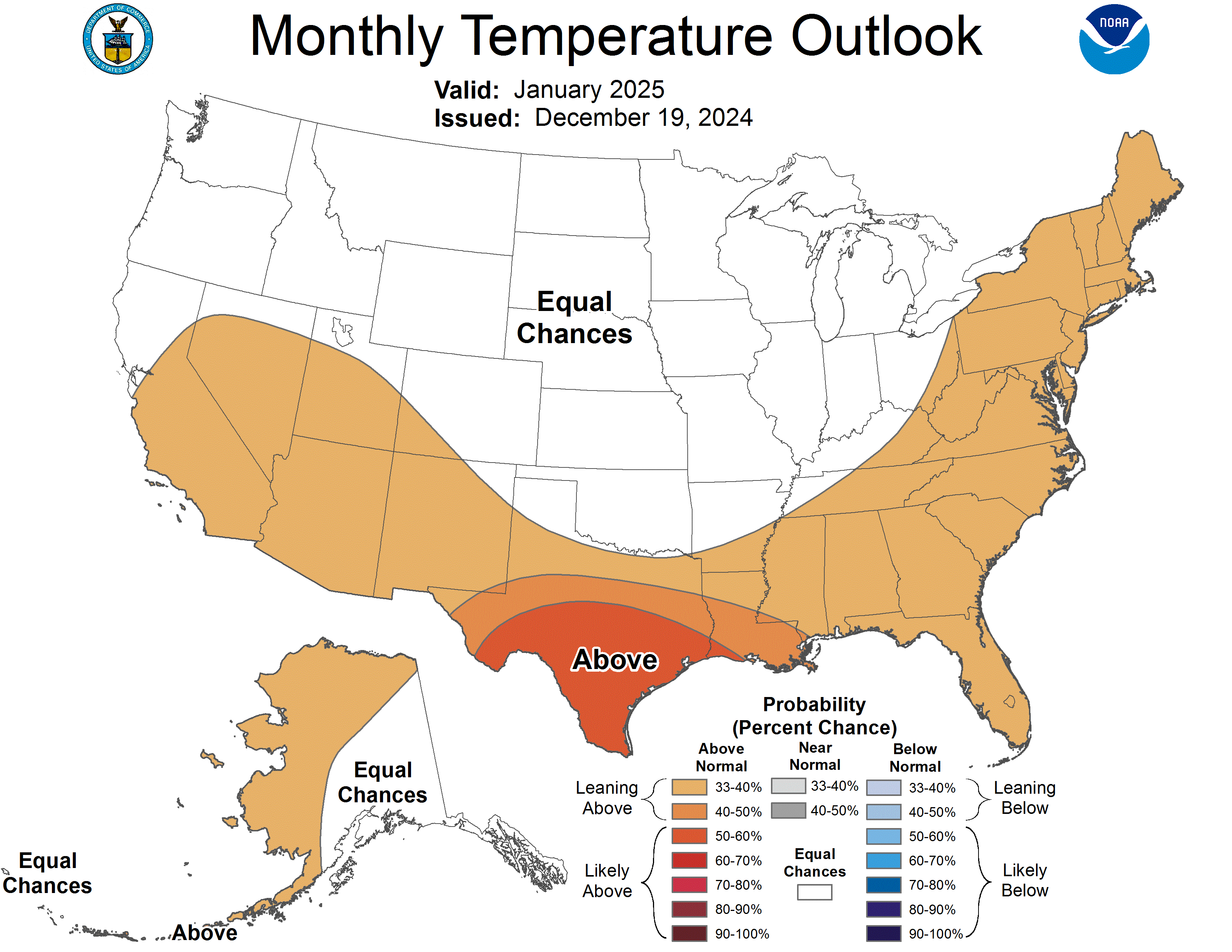


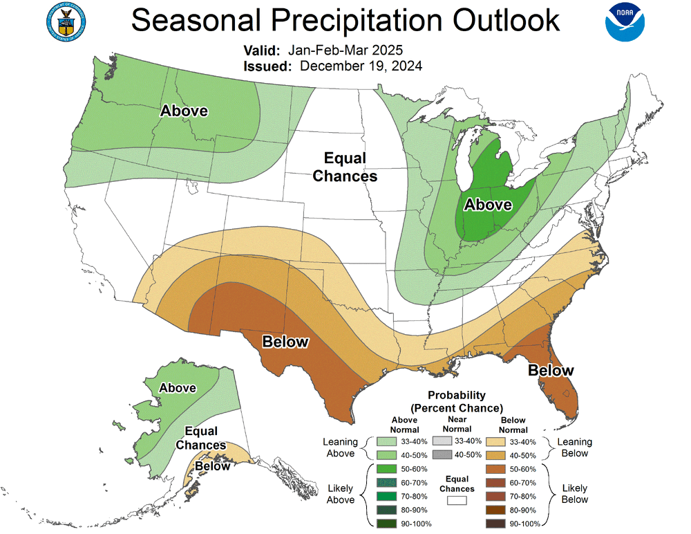
Christmas 2024 Grinch Storm Potential
in Lakes/Ohio Valley
Posted
I'm okay with it. Something needed to be done to break the cycle, like someone splitting in blackjack when they shouldn't or taking a card they shouldn't of.