

Stevo6899
-
Posts
2,514 -
Joined
-
Last visited
Content Type
Profiles
Blogs
Forums
American Weather
Media Demo
Store
Gallery
Posts posted by Stevo6899
-
-
It's been a minute since I've been on the east side of a low and still have dynamic cooling take over. Temp dropped 6 degrees past 2 hours.
-
Definitely 2 inch per hour band. Doesn't get much better locally as far as rates go. If only it could stick around for a few more hours.
-
 1
1
-
-
2 minutes ago, A-L-E-K said:
we took another L
Definitely a bummer to have back to back respectable storms and have to worry about cold air/accumulation. I'd rather have warm and dry like December. Congrats to those in the nw sub though.
-
1
-
-
7 minutes ago, Stebo said:
Its heavy snow and sticking here at Metro, ground already coated too.
Yea the short range models have been consistent in showing a decent band from dtw up through troy/Pontiac all day.
-
From a friend in troy, 10 miles west, it's heavy and sticking there.
-
Just now, Powerball said:
lol...
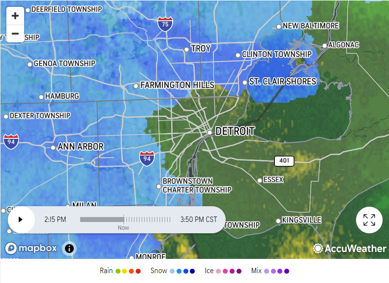
Yea one minute it's heavy snow, next its rain. Always riding that line here on the east side it seems.
-
Looks like multiple low pressures, one in se Ohio, which I don't think was modeled. Helluva dry slot coming north. White rain to start here and just flipped to snow in central macomb. Not gonna accumulate much with temps at 37. Just a little too far east to get the goods. Good luck to the rest. Central Oakland looks like a good place to be on the latest rap.
-
7 minutes ago, AWMT30 said:
@Stevo6899 Looking real good for some big time rates later on this evening for us. Things might work in our favor for once......
I'm afraid sleet will mix in but about 50 miles west towards Pontiac into Oakland county may jackpot. Definitely the heaviest snow we get around here as far as rates go.
-
3 minutes ago, mimillman said:
Where is cyclone. Those returns have to be yielding 1-2” per hour for the past several hours and it’s not moving
Looking at reports from last storm and the radar now, that area probably will have over a foot of snow depth.
-
2 minutes ago, WestMichigan said:
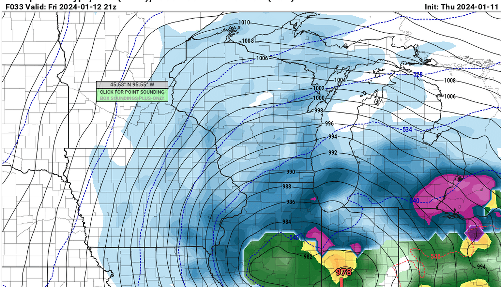
The lack of agreement between the models even this close to an event is surprising.
I think because a new lop is popping further east is giving the models fits. Most storms come down to nowcasting when it comes to banding but this event especially.
-
1
-
-
4 minutes ago, Michigander said:
Looks like a dry slot running through mid and SE lower MI in the latest HRRR
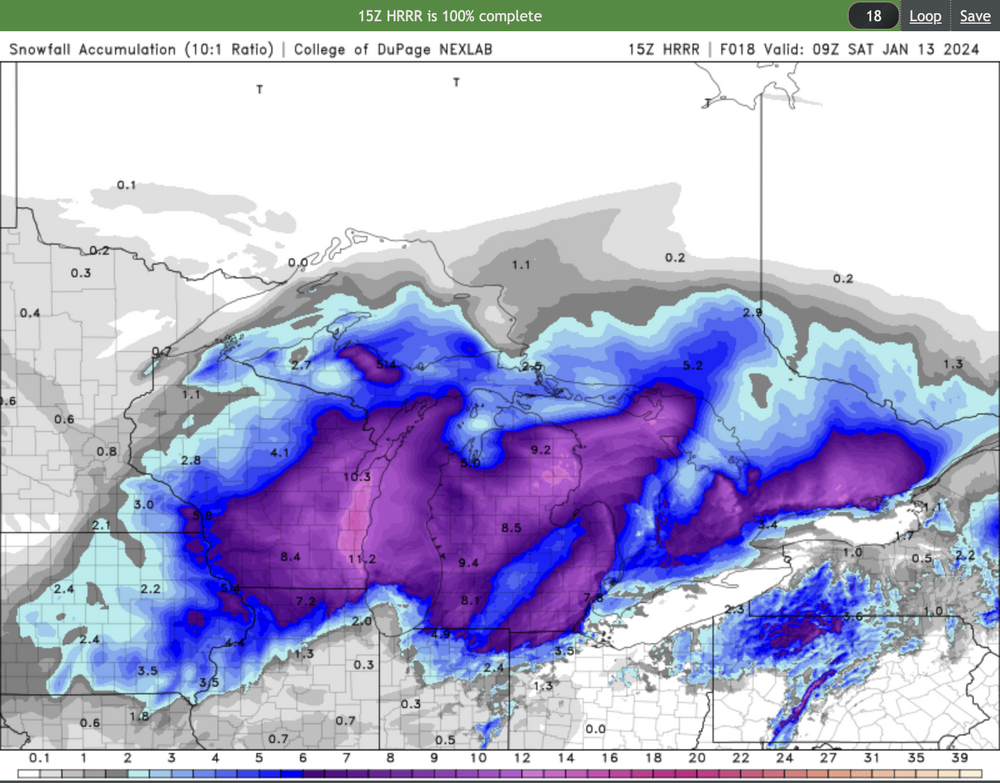
Rap/hhr with an inch plus of precip in 6 hours at dtw up towards east side of metro area. Hoping to see some awesome rate and not pingers.
-
1
-
-
21 minutes ago, Stebo said:
Yeah, I will say this, the low that is supposed to come north is definitely on the east end of the guidance right now.
Some of the models have a sharp cut off east of 75. Like 10 inches in the hills oakland county, and like an inch of slop east into macomb. Shall be interesting.
-
Is anybody in here from ames? This is the second storm in a row that they have been in a killer def band. It's 17 and heavy snow. Wonder what the ratios are out there.
-
18z rgem not as wound up. It keeps showing all snow for dtw for awhile. Skeptical but if rates can stay heavy, maybe dynamic cooling can deliver.
-
9 minutes ago, nwohweather said:
Unreal runs on the GFS...
Almost 24 hours out and it's showing 0" essentially on the Euro & 4-6" on the GFS for Toledo. This is insane
As much as I want it to happen. I don't recall the last time we were on the east side of a low this strong, and it remained snow for more than an hour or two. Could be ripping for an hour or two if dynamic cooling occurs and I guess we'll have to take it. Hopefully the arctic crap behind it doesnt last too long.
The 12z euro snowmap perfectly illustrates the history of how detroit is so close to big snows. Sure the city gets 10+ storms maybe every couple years but the amount that turns out like this one is far greater, maybe 4:1.
-
Just now, WestMichigan said:
RGEM and ICON buth have less QPF and even with the RGEM east solution snow totals are much lower in MI.
I'm not saying we're gonna jackpot but the rgem actually has higher qpf over towards to dtw, albeit shitty ratios. I also think models may be overdoing the strenghth. Rgem has been pretty consistent. Alot can change in 48 hours.
-
Dtw crew would take the 18z rgem and run. Not as wound up and east.
-
We always rip on dtx but grr is probably as bad if not worse regards to issuing headlines on time lol. I always enjoy their afd's and discussions which makes it weird.
-
4 minutes ago, HillsdaleMIWeather said:
Hoping for a last second slight eastern shift so us Michigan peeps get the better snows too
Yea my gut is telling me the models are overdoing it with the strength. I think the 12z Canadian is more realistic. I think grr over to flint and up to mount pleasant will be the jackpot. Detroit may see a few sloppy inches.
-
As stated last week, road trip to cmu. 10-20 inches. Bummer to miss out on 2 respectable events in 4 days. It's too bad this midweek storm couldn't pull down more cold air like this weekend one is. Cold and no snowcover, gross.
-
19 minutes ago, mimillman said:
NAM east, RGEM west. Fun
Rgem basically ends up in the same spot as tonight's low, sub 980. Pretty remarkable. I can't remember the last time we've had two storms of this strength in a span of 4 days. Every model today has strenghtnened the low and gone NW. Are they overdoing it? Also being so close to the low per rgem, I'm not sure I buy there not being a dry slot into michigan.
-
9 minutes ago, nwohweather said:
Hell of a storm for Toledo on deck, one of the best I've ever seen if it pans out on the GFS.
Even sexier on the rgem, however it was SE with this current storm at this range so who knows at this point. Ukie/euro way nw.
Also the deformation snows look to be very tight and close to the low which hopefully will keep the dry slot away, that the euro/ukie show.
-
I guess we shouldn't be surprised that the nam is in the amped euro camp.
-
 2
2
-
-
9 minutes ago, Stebo said:
It could be when he has lived down south

Yea I dont know his history of where he's lived or for how long. I know he recently moved to Dallas but its not believable to have 10 hours of pingers no matter the location. insert middle finger emoji.

Jan 11-13th Blizzard
in Lakes/Ohio Valley
Posted
Yea saw some lightning a few times. I was expecting more rain here on east side but its been all snow and been coming down for 4 hours now. Nothing significant but definitly a pleasant surprise.