

Stevo6899
-
Posts
2,768 -
Joined
-
Last visited
Content Type
Profiles
Blogs
Forums
American Weather
Media Demo
Store
Gallery
Posts posted by Stevo6899
-
-
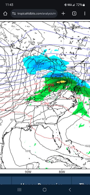
Bullseye on 12z for metro detroit. Obviously you're always leery of a Northwest shift and we still got a system today and another one to go through so likely some changes to come. Lansing to chicago is a good place to be imo as it leaves wiggle room for some more strenghtneing.
-
27 minutes ago, Powerball said:
There's going to be hard limit on the NW extent of this storm, given the overall flat/progressive pattern aloft.
That said, the impressive baroclinic zone in place will support some nice frontogenesis banding in the cold sector. Feb. 2007 and Dec. 2000 might be good analogs...
Yeah that's probably one good thing about this pattern that we've been in is we haven't had to worry about storms going to our West. We just gotta ride that thin line all the time. It just bugs me to see these systems be so meager in the midwest but as soon as they get to the coast they develop and it's an automatic 6 for boston lol.
-
Could this finally be the first storm for what seems like forever that doesn't trend southeast and weaker...
-
1 hour ago, michsnowfreak said:
The last 6"+ storm at Detroit was March 3, 2023. (the largest storm last winter was 4.7", and the largest this year to date has been 3.7").
The historical average is just over 1 storm per winter of 6"+.
However, there have been obviously many years where we dont see one, particularly in the middle third of the 20th century.
The most 6"+ storms in a single winter was 6 in 2013-14.
The most consecutive winters withOUT a 6"+ storm was 6, from 1944-45 thru 1949-50.
The most consecutive winters with at least one 6"+ storm was 14, from 1890-91 thru 1903-04
The decade with the least 6"+ storms on record was the 1940s, when just one storm of 6"+ fell
The decade with the most 6"+ storms on record was the 2010s, when 19 storms saw 6"+
Despite not having a 6"+ storm since March 3, 2023, we have already seen 6 in the 2020s.
Thanks for the reply and info. I had no idea we went all last winter without one. That stat of going 6+ winters without one is depressing and shows things could be alot worse and we definitely have been spoiled recently/puts things into perspective.
While I wish we could get bigger storms in our area, that's just not our climo. It doesnt make our climo suck, its just the way it is and no sense in getting all upset over it. Easier said than done though when you see big dogs hit other areas but that's the luck of the weather. If we can score one 8+ storm this winter, I'll be happy. I am guilty of having way too high of expectations regarding our climo.
-
 2
2
-
-
This weekends storm cracks me up, Detroit in between precip areas with zzzz. Not that it's an impressive storm but had chance at being decent. It's pretty hard to go a whole winter without a 6 inch event. When's the last time that happened Josh? We gotta be close to having it happen the latest in the winter, mid feb at the earliest this winter..
-
Gfs somehow has bullseye 6 over detroit for the weekend.... definitly gonna be a nowcast event it seems.
-
 1
1
-
-
1 hour ago, Malacka11 said:
Just about two weeks away from the end of malackalogical winter, so either we get a nw trend sometime next week or
Today's run of the euro has I think the first sub 990 storm I've seen in the region on any run this winter.
-
 1
1
-
-
3 hours ago, A-L-E-K said:
it's bad folks
Obviously still a few days left but it's only fitting that the low pressure for the weekend doesn't get it's act together until it's well east of the area.
-
1
-
-
If only the weekend system could slow down a bit, but nonetheless looks like it has potential to be biggest event of the winter for northern burbs.
-
3
-
-
Euro with a bowling ball type wave for next weekend. Atleast it seems it's getting a little more active.
-
43 minutes ago, Lightning said:
Solid SN+ here right now with silver dollar flakes falling. Solid rain event with 1.5" of rain recorded at Howell airport.
Definitely a legit 2 inch per hour band along 59. Pretty impressive to see it accumulating so fast on a wet ground. If only this could last 12 hours.
-
32 minutes ago, SchaumburgStormer said:
Solid pivot action overhead, good amount of flooding with the frozen ground. Up to .8”
36 and rain, while bands remain stationary overhead. Go from single digits and bone dry to just above freezing and cold rain. Easily an F winter so far. I have a feeling though that winter will end on a good note later next month.
-
16 minutes ago, A-L-E-K said:
EPS/GEFS nearly bone dry after the cutoff rainer friday, p wild to see the model volatility in that range
Everything that comes along is just too progressive and weak. Even last weeks gulf snow was a progressive. We need more of a buckle in the jet stream and in the right place. I don't think alot of us realize how many moving parts need to come together to deliver the goods. Makes you appreciate them more when they do come
-
1
-
-
9 minutes ago, A-L-E-K said:
At least it's different
Were gonna go from suppression, to wagons west. Guess it's better than teens for highs.
-
1
-
 1
1
-
-
18 hours ago, dmc76 said:
Oh god
Without me you wouldn't ever post on here so keep being obsessed with my hot takes. Enjoy that cold this week
-
 2
2
-
-
2 hours ago, michsnowfreak said:
Not even a major snowstorm. He has said many times he wouldn't come home for a 6-12" snowstorm. It must be nearly apocalyptic. I remember him ridiculing the 2021 storm that dropped 8-10", even though it left 12-18" of snow on the ground area wide in its wake, and now he "doesn't recall it". He actually complained about the historic 2013-14 winter. You know, the one with 94.9" of snow, record cold, and record annihalating snowdepth in the double digits for MONTHS...because no single storm had over 12". Of course, the following winter had the GHDII storm where DTW got 16.7", but that storm was ridiculed for taking too long (it was like 26 hours). Meanwhile if the east coast gets a 3-6" or 4-8" storm, no matter how long it's been.. watch out! His M.O. is clear.
Huh? I was just saying our area may be the last to see a decent storm this winter and that I look forward to your turd polishing this winter. No 6-12 inches in 20 hours isn't warranted for a trip home. One day I'll accept you're shitty criteria for good winters/storms. Maybe next year....
-
1
-
2
-
-
3 hours ago, Stebo said:
So you complain from somewhere else about missing snow that you wouldn't see unless it was a major snowstorm? You are ridiculous.
We talk about snow and the cold on here. Aren't we all ridiculous? Maybe I'm next level ridiculous. I fly home every weekend to check on mom. What's the difference where I am when I complain about our shitty winter?
-
1
-
-
3 hours ago, michsnowfreak said:
As do i look forward to your continuous lies and exaggerations about recent/past winters and storms (which are constantly proven wrong by me and others). It's kind of wild how it bothers you so much that I like all aspects of winter, especially since you don't even live here most of winter.
Def not proven wrong. I was just saying all we got to look forward to is how you will spin this winter as avg and not that bad. I don't live up there in the winter but I wanna hop on a plane for a snowstorm lol. 6 winters in a row no flights back. Luckily I was home still in Nov 2019.
-
1
-
-
Come mid february and were still waiting for a decent event, I'm really looking forward to Josh turd polishing this winter so far as not that bad as he references the past week of the 4-6 inches that accumulated over a 100 hour period/week of snowcover. Followed by 3 days of useless days in single digits, then rain with the next event.
-
 1
1
-
-
38 minutes ago, Snowstorms said:
La Nina needs to La Nina for us to start scoring. The pattern so far hasn't been that of a typical Nina.
True. Usually weak Nina's are good for us but as always enso isn't the end all be all for patterns. Thats why I roll my eyes when someone posts the precip/temp maps for the upcoming weeks as they are just created based on enso alone it seems. So many things gotta come together outside of (nao/pna/ao) for a favorable pattern for certain parts of this sub. The end of the gfs run looks promising pattern wise. It's been cloudy the past 3 days here in SW Florida with that looking to continue for another 5-7 days. Pretty rare this time of year as it's usually sunny and only cloudy when a front rolls through. Gotta get outta this suppression and move that baroclinic zone back north.
-
1
-
-
59 minutes ago, SchaumburgStormer said:
Hope you are ready for your early may snowstorm
Yea that would totally make sense. Come mid march I'm ready for warmer weather. I feel like our best chance for a big dog is in march when we gotta thread the needle and more moisture available.
-
13 minutes ago, A-L-E-K said:
confirmed
We may be the last ones to see a substantial snowstorm. Hopefully it'll be worth the wait. South had theirs with ohio valley, east coast next. I believe msp had a 6 incher in december?
-
1 hour ago, A-L-E-K said:
6z gfs shit out a much different solution (not surprising given the pesky cutoff), almost a detroit major
Euro was pretty close also. Something to keep an eye on.
-
1
-
-
14 hours ago, nwohweather said:
Why do you say that? It looks like the coldest temps in years are possible and we keep getting these 2-3” hits. It’s as winter as you could hope it could beThat's criteria for a snoozefest for me. Ain't gonna get any decent snowstorms with temps in the teens/suppression. I think the majority of us on here hold out hope for a little more, but hey enjoy the cold and snowcover if that gets you excited. The lack of any respectable event to track this winter in the Great lakes is surprising as we essentially are 2 months into winter storm tracking time. We haven't even had the opportunity of having a good storm modeled for days and have the carpet pulled out from under us and it disappearing last minute.
-
1
-

2/12 Winter Storm
in Lakes/Ohio Valley
Posted
Does this kinda pattern lean towards storms strenghtneing more than models think, thus nw trends instead of weaker/se like we've seen for awhile?...