ikcarsky
-
Posts
61 -
Joined
-
Last visited
Content Type
Profiles
Blogs
Forums
American Weather
Media Demo
Store
Gallery
Everything posted by ikcarsky
-
April 27-28 Potentially Historic Super Late Season Winter Storm
ikcarsky replied to Hoosier's topic in Lakes/Ohio Valley
Do weenie cards expire on March 21? Mine certainly doesn't. I'll take AFD's like this one out of MPX any time of the year. However, one thing this system has in abundance is strong forcing. There are contributions from isentropic ascent, upper level divergence, differential PVA, and mid-level frontogenesis. All of these show strong signals, and are very well correlated both spatially and temporally. Net adiabatic isentropic Omega lines up quite well with model omega, and with mixing ratios of 3-4+ g/kg there is more sufficient moisture for at least 8" of accumulation. Add to this the fact that strong 700 mb frontogenesis is progged, and couples well with upper level divergence (initially in the left exit region of the upper jet streak to our north, but eventually during 12-18Z it is a coupled feature as the jet streak to our southwest gets into the picture). Negative EPV is indicated above the sloped region of frontogenesis, owing to convective instabilty per negative theta-e lapse rates in the layer. This simply adds to the potential for intense banded precipitation for a 6 hour or so window of time. I'd say send this thing my way but if the trend on the high-res models continues this is going to become a Chicago special. I don't quite buy that since the upper level signature of the s/w over the PacNW looks pretty potent in water vapor imagery which to me argues against further southward shifts. -
April 27-28 Potentially Historic Super Late Season Winter Storm
ikcarsky replied to Hoosier's topic in Lakes/Ohio Valley
I missed out on the mid-April thundersnow. I'm surprised that late April is bringing a 6"+ contender but even more surprised that it will be whiffing to me to the south. Congratulations to Madison + 1 county N/S, looks like that's where the death band will be setting up W/E in the state. I'm only looking at 1"-2" from THIS storm but at least now GRB is talking accumulating snow from an inverted trough that swings through Sunday night. If that squeezes out another 1"-2" I'm pretty sure the back-to-back snows would be historic for the time of year, if less dramatic. -
Almost three weeks after the Great Plains Pulverizer and our dry spell persists. Snow now only exists in piles and a few of the larger drift zones, particularly those that are a bit sheltered. Different story once you get north of Wausau though. The transition to deep snow pack happens in all of about 20 miles. Near Rhinelander there's a consistent 12" depth, nearly 18" in some places. And it's an absolute glacier too. I hardly sunk 1/4" into the top when cross-country skiing up there yesterday. Kind of stunk actually. That said, with no 1"+ refresher snows in the forecast and with 70s trying to work their way into the long range I can't see that glacier holding on much longer. Meanwhile is that a snow squall I see approaching on high-res for tomorrow evening? I'll still take winter where I can get it.

-
When looking out at a deep 2' snow pack the morning of March 12 I thought I wouldn't see lawn grass until April. Nope. As of now areas of bare ground tend to exceed covered areas. Fields are almost completely free of snow aside from drift zones. By the time the potential storm rolls around later this week it'll just be snowbanks. It's not like it's been excessively warm here, but we've lacked any refreshing 1"+ snows to help keep the snow pack fresh and a good reflector/radiator for the numerous clear days we've had since the bomb cyclone. Since that storm we've had only a few hundredths inch of QPF. Blah.
-
It's not literally a sand bar. Poor analogy. The point I was making is that the soil is very sandy and permeable in this region, and ordinarily puddles have very poor staying power...when the ground isn't frozen solid that is.
-
I've heard it said that my area is immune to flooding because it's basically built on a giant sand bar. Well, turns out that logic doesn't hold up when the ground is frozen. This torch (three days, almost 60° today, with sun) melted about two-thirds of the snow pack. Throw on the 1.5" of rain and there's a lot of urban flooding. Some county roads are underwater too. I've also heard word of some basements taking on water. Sump pumps have been selling well locally. So with all that I am glad the torch is over. It should be downhill (no pun intended) from here. And things could have been worse The snow pack is I'd say about 6" average depth and has plenty of water yet to give.
-
For fun, of course. And since it is just for fun, in the end people will use whatever scale they wish -- including how they feel. All I can do is explain why I prefer a more objective standard. Atlanta will never ever get a grade-A winter. International Falls will probably never ever have a grade-D winter. In imitation of life...some students just won't ever get A's no matter how hard they try. Come up my way, this three-day torch was no match for our epic snow pack. It may be slushy on the bottom but it still white on top and no grass is poking through yet.
-
I think I see what you mean by "both ways" but this is awkward to me since the entire point of being objective here would be to provide a single standard by which a winter should be judged -- no matter where you are in the world. Which standard to choose? Pure numbers (80"+ seasonal snowfall) or relative to climo (10"+ above average)? I would rather judge on criteria closer to the former than that latter. There is some enjoyment from breaking records and knowing a given season is unusual and as you saw I do give points for that. I just don't think it should be the basis of the scoring rubric. To go off of your example, someone from the South coming living in Chicago for a year would be impressed by even a climatologically average Chicago winter, but even they would have to some sense of what a real "grade A" winter would be like, and that it wasn't what they experienced in Chicago. Our culture gives the impression (reinforced around Christmastime) that winter means kids are bundled up from head to toe, the hearth is ablaze, and the snow is deep enough that you could use sleighs to get around. You see it on decorations, media, your coffee mugs, etc. And there are places in this country where that can happen on a consistent annual basis. Shouldn't these places be the "grade A students" of winter?
-
I noticed MSP was the last place in MN to change over. Surprised at how long it took. UHI influenced perhaps? It was during the day and most areas getting snow were a degree or two above freezing as far as a could tell. Getting optimistic for 6" here for my area. Precip is becoming a bit better defined on the leading edge of the 700 circulation which is now in SW WI. You can see the circulation quite well via the radar loops which is definitely not the surface low (which is over ORD).
-
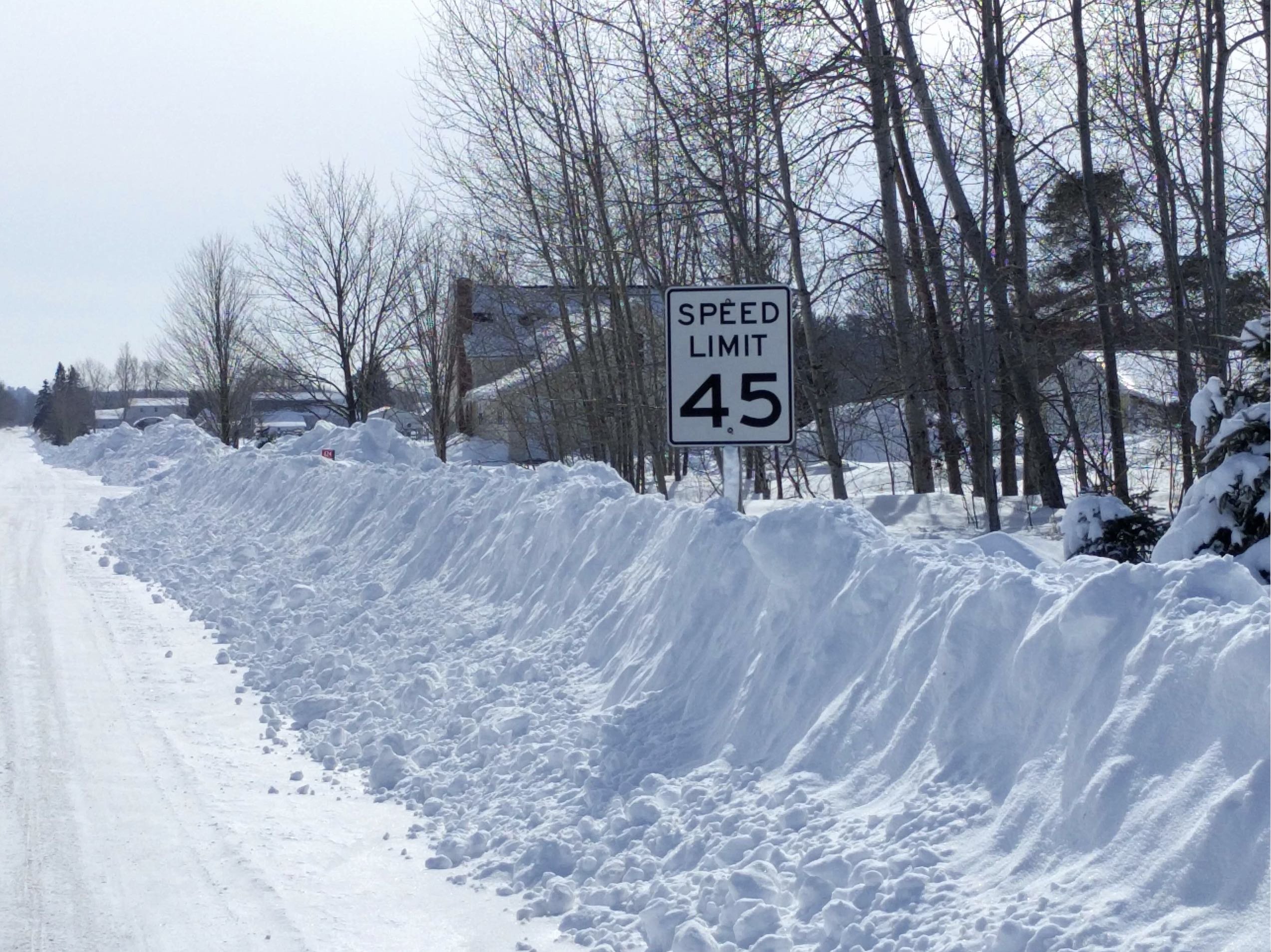
I share the sentiment that winter should be judged on an objective basis, not relative to climo. Which is why I moved to a place with better snow climo. In that respect Dec and Jan were altogether average, maybe even a bit below. But Feb was an A+, and gets extra credit for just completely smashing the record books with respect to snow: • Parade of sliders generally giving 3"+ of snow every few days • All-time season snow records smashed. 80"+ on season thanks to monthly record of 44" in Feb alone • A couple of big dogs - 2/12 which dropped a whopping 15" - 2/24 blizzard, started with almost 1/2" freezing rain and ended with 7" of snow with powerful winds (took out lots of power in my area) • Only a couple notable thaws (~2/3 and ~2/23); fairly brief, temps didn't exceed 40, only took tiny bites out of the snow pack. • The snow pack itself reached just insane depth by mid-month and we're still holding onto it. (And areas north of me got even more!) Even after this recent two-day thaw with March sun it's almost two feet deep even in the middle of suburban lawns. Here's an example of what some roads were like by 2/28. Not bad considering I'm well outside of LES zones. Throw as extra credit: -30s in late Jan, and the first week of March feeling like deep midwinter, and I come up with an overall B+ grade. Very content.
-
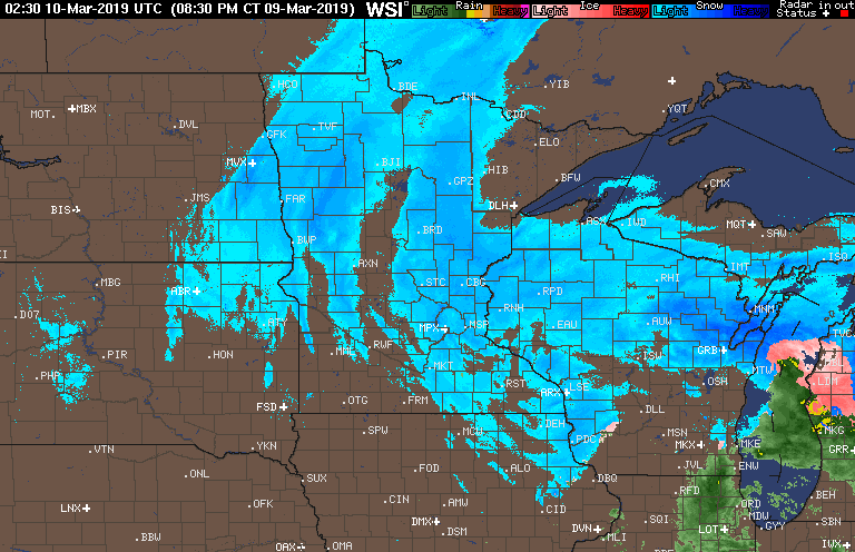
I gotta give some love to this one. We didn't see a drop of liquid like they were forecasting. NWS is blaming the stiff dry east wind all afternoon that kept dew points in the low 20s. Snow/sleet started about 5:45 pm, intensity picked up half an hour later and by 6:45 pm it was CRAZY intense snow. Gotta love 850 frontogenesis snow giving us an amazing band that dropped 2" in one hour. But by 8 PM it was all done and now it's just light stuff now as I find myself smack dab in the central WI snow hole. Wind died down quite a bit too. Fingers crossed that the defo snow action picks up now.