

ikcarsky
-
Posts
61 -
Joined
-
Last visited
About ikcarsky

-
Tuesday – Added another 1.5", totaling 3" of lower ratio stuff than the 3" on Sunday. It accumulated until around noon so it was actually more impressive than Sunday where rates were too light during the day to combat insolation. Wednesday – Heavy snow late afternoon driven by daytime heating and cold 700 mbar layer. Great rates, estimated a quick 0.5". Thursday – A "fun surprise" of my own early morning, good rates early and about 1". "Fun" because I had to drive to work during peak rates. Intensity let up the moment I stepped out of the car (naturally). Add Sunday 3" and that's 7.5" over five days (Monday may have had a trace idk). With temps generally less than 40 every day making for a decent winter-going-on-spring feel by my Midwestern standards.
-
I knew someone would really cash in with this dynamic ML energy after I got Severe T-storm warned thundersnow Saturday evening. Bad Kuchera maps let much of my sub down but better late (farther east) than never, congrats to all that made bank on a wild one.
-
1.5" of fluff so far this morning. Started off with nice dendrites and good rates between 5 and 5:30 AM with a brief but intense wave of forcing that was poorly handled by models (only yesterday showed up and only on high res). Light pixie dust continues. Loving the midwinter feel.
-
Amazing how insolation can nuke a thin snowpack down here even when temps stay below freezing.
-
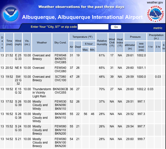
No -10's in ABQ, but might get close to 0 tonight. Forecast low 6. Filtered sun overpowered the flurries and temps hovering around 15 this afternoon to make roads pretty good. Now that snow showers should end soon safe to say my final total is 3" but compaction/sublimation already doing their thing. Snowpack is widespread though, hope it's sturdy enough to reduce the risk of rain with the clipper tomorrow by holding down temps just that extra degree.
-
Woke up to 2.5". Pavement has 1.5"-2" so not as much lost to melting as usual. Pixie dust still falling and radar shows several hours are likely yet. Wind is DEAD CALM but the dull roar of the 60 mph canyon wind about a mile to my south can be heard, for which blizzard warnings were hoisted. Eerie. Clipper mentioned in the AFD this morning, is this ABQ or GRB? LONG TERM...(MONDAY NIGHT THROUGH SUNDAY)... A clipper system is soon to follow behind today`s Valentine`s storm, beginning Monday night. Accumulating snowfall will begin across the northwestern portion of the state late Monday evening. Precipitation expands across central New Mexico through the day Tuesday and into northeastern portions of the state Tuesday night. Both the 00z GFS and ECMWF try to bring in a backdoor cold front late Tuesday night that keeps precipitation in a convergence zone along and east of the central mountain chain through Wednesday. The system exits late Wednesday, with the GFS forming a closed low over the TX panhandle. Temperatures were lowered below NBM guidance for Tuesday and Wednesday, particularly across northeastern New Mexico, where snow cover is likely to hang around for several days.
-
Around 4 PM winds at KSAF went SW -> SE and temp started plummeting which hinted the Arctic air was cresting the mountain passes, about four hours ahead of schedule by my reckoning. And now with the latest out of KABQ I think Albuquerque is officially in the same boat. Precip should be snow from here on out. Weenie mode activate.
-
thundersnow_ABQ.mp4 The action had mostly passed by this point. The really heavy precip was maybe 90 seconds tops, small dense balls of snow, like a snow/graupel hybrid. But: thundersnow confirmed.
-
Lol -- real life 0z ABQ sounding had 37 J/kg of MUCAPE, gotta love dynamic systems Severe Thunderstorm Warning Severe Weather Statement National Weather Service Albuquerque NM 615 PM MST Sat Feb 13 2021 NMC001-043-140130- /O.CON.KABQ.SV.W.0001.000000T0000Z-210214T0130Z/ Sandoval-Bernalillo- 615 PM MST Sat Feb 13 2021 ...A SEVERE THUNDERSTORM WARNING REMAINS IN EFFECT UNTIL 630 PM MST FOR SOUTHEASTERN SANDOVAL AND BERNALILLO COUNTIES... At 614 PM MST, severe thunderstorms with snow and hail were located along a line extending from San Felipe Pueblo to Albuquerque, moving east at 35 mph. HAZARD...60 mph wind gusts. SOURCE...Public. IMPACT...Expect damage to roofs, siding, and trees.
-
Lightning! Quite a show with the band ongoing north side of ABQ given the time of year, I'd say about 4-6 strikes a minute. Lots of curly arcs poking beneath the cloud deck. I don't even remember any instability progged by any model sounding, I'm quite impressed. Very dynamic system -- gives me good feeling about snow tonight.
-
Insuring they're properly insulted, not ensuring. You also need to take out a policy that will protect you from liability in the event the pipes aren't sufficiently demoralized by insults that are too shallow.
-
One thing I've noticed in recent days is the modeled longwave pattern is more stable I can ever remember it (at least on GFS). Even out to ~240 hours, the positions of troughs/ridges from run to run predicted for a given date haven't been changing much. I suspect this will change once we're back to a faster zonal flow pattern. In the meantime T-24h to the main show, NWS ABQ going with 2"-4" for the metro area. Nothing staggering but at least it won't melt right away. Plus the Tuesday system looks juicier than a few days ago.
-
NWS ABQ seems optimistic there could be a return. GFS and ECWMF continue to prog a third system for Tuesday of next week, keeping colder weather along with good chances for snow to much of the forecast area. Drier and warmer weather appears on track for late next week. The overall pattern in the Pacific is not expected to change during the remainder of the February with additional trough forecast to dig southeastward over the Southwest U.S. Credit a convectionless EPAC with the MJO stuck in phase(s) 6/7 thanks to a fading La Nina.
-
Models seem to agree on spitting out a low from the current NPac cyclone chaos that heads toward the West coast, undercutting a ridge that gets set up over Alaska. Key difference is Euro has a weak Alaskan ridge on D5 which breaks down and retrogrades toward Siberia. GFS/CMC are stronger and keep the ridge in place longer, which together with the NPac low looks to entice the NoAm TPV to extend westward and swing some truly frigid air down the Rockies all the way to the coast. I thought I remember hearing the Euro had a bias with breaking down ridges too quickly but that may be in the tropics, I don't remember.
-
Serious cold all the way to CA on the 12z CMC Sunday morning, 8 days from now. It's preceded by an awesome overrunning snow event for N AZ and NM. Weenie 10:1 snow map paints 2'+ for some of the NM western mountains and generously spits out 1'+ to much of the central and western part of the state. Even if this did come to pass looks like a good setup for a canyon wind down the central mountain chain and much of ABQ metro still gets snow holed. Anyway this all looks dependent on some delicate wave breaking action to occur in the North Pacific Ocean in a few days due to the current maturing cyclone south of Kamchatka, which spins off some vorticity into the Gulf of Alaska on Wed that pulls on a lobe of the NoAm TPV, elongating it toward the N Pac, or something like that. My mind boggles at all the NPac vorticity lobes phasing and shearing and puking on the 500 mbar chart tbh but it does assure me that what the CMC shows is not gonna happen.

