ORH_wxman
-
Posts
93,092 -
Joined
-
Last visited
Content Type
Profiles
Blogs
Forums
American Weather
Media Demo
Store
Gallery
Everything posted by ORH_wxman
-
December 2021 Obs/Disco...Dreaming of a White-Weenie Xmas
ORH_wxman replied to 40/70 Benchmark's topic in New England
Look at the difference in California at 84 or 90h on the 18z run compared to 12z....that is LOL. You don't typically see the Euro make jumps like that. -
December 2021 Obs/Disco...Dreaming of a White-Weenie Xmas
ORH_wxman replied to 40/70 Benchmark's topic in New England
18z GFS was pretty nice for SNE on Xmas Eve. Nice stripe of 1-2”...prob some lollis to 3” in there with QPF approaching a quarter inch in spots...esp from NE CT over to SE MA. Would like to see Euro start getting on board though. -
December 2021 Obs/Disco...Dreaming of a White-Weenie Xmas
ORH_wxman replied to 40/70 Benchmark's topic in New England
Leon? That's almost a Jan '94 look for early to mid January on the weeklies with the NAO going positive, but the PV settling down into Hudson Bay and a big AK ridge. Hopefully it has the right idea. -
December 2021 Obs/Disco...Dreaming of a White-Weenie Xmas
ORH_wxman replied to 40/70 Benchmark's topic in New England
18z NAM not as amped as 12z for Wednesday. -
December 2021 Obs/Disco...Dreaming of a White-Weenie Xmas
ORH_wxman replied to 40/70 Benchmark's topic in New England
If it does, that would likely bode well for late January and into February. I'm always a fan of bucking February La Nina climo. -
December 2021 Obs/Disco...Dreaming of a White-Weenie Xmas
ORH_wxman replied to 40/70 Benchmark's topic in New England
Euro is basically splitting the 50mb PV....will be interesting to see if it actually splits or just stays really elongated....it doesn't really matter in the medium range....being stretched like that is going to be exceptionally favorable for blocking....but longer term it will matter on the longevity....if it splits apart, it will take longer to re-consolidate. -
December 2021 Obs/Disco...Dreaming of a White-Weenie Xmas
ORH_wxman replied to 40/70 Benchmark's topic in New England
Yeah tickled south some...even the mean snow algorithm has N ORH county into the 2" range now. Not that I put much stock into snow algorithms, but having that increase a bit shows the colder solutions becoming a little more numerous. -
December 2021 Obs/Disco...Dreaming of a White-Weenie Xmas
ORH_wxman replied to 40/70 Benchmark's topic in New England
I had 0.1" in Dec 2018, but we had two events in November 2018 including a warning criteria event (that gave us a white T-day) -
December 2021 Obs/Disco...Dreaming of a White-Weenie Xmas
ORH_wxman replied to 40/70 Benchmark's topic in New England
2015-2016 was the last winter where I didn't get at least an advisory level snowfall prior to New Years...you'd have to go back to 2006-2007 for the next one. So it obviously happens, but it's fairly rare. Especially inland. Right on the coast it's a bit more common. Both of those years I mentioned were El Ninos too. You'd have to go back to 1999-2000 to find one in a neutral or La Nina. -
December 2021 Obs/Disco...Dreaming of a White-Weenie Xmas
ORH_wxman replied to 40/70 Benchmark's topic in New England
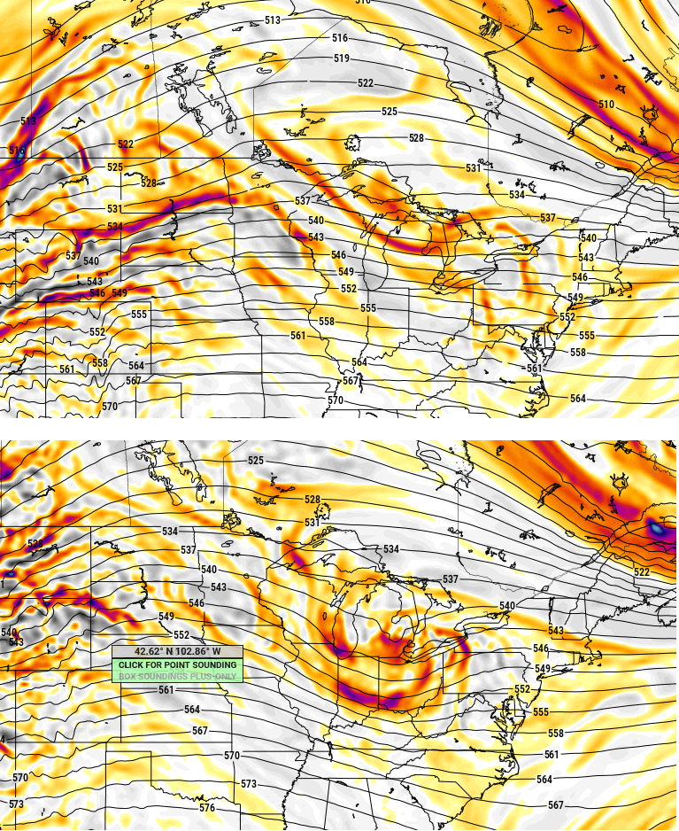
Check out the difference in the Xmas Eve shortwave on Euro vs GFS....this is only an 84 hour prog. Euro on top and GFS below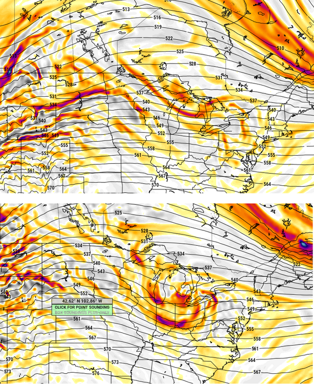
-
December 2021 Obs/Disco...Dreaming of a White-Weenie Xmas
ORH_wxman replied to 40/70 Benchmark's topic in New England
24th could give a couple inches if the energy ejected is a little stronger ala GFS (lesser extent the GGEM)....Euro and Ukie are pretty weak with it...not a good kink in the isoheights. The stronger the shortwave on the 24th, the colder Xmas will be too because it lowers the heights behind it a bit. -
December 2021 Obs/Disco...Dreaming of a White-Weenie Xmas
ORH_wxman replied to 40/70 Benchmark's topic in New England
Airmass is decent for 12/24....but questionable for 12/25. IF 12/24 comes in south, that also helps for 12/25. There's several moving parts...12/22 affects these too. Euro run is south of 00z for 12/25 but still too far north for most of SNE. -
December 2021 Obs/Disco...Dreaming of a White-Weenie Xmas
ORH_wxman replied to 40/70 Benchmark's topic in New England
Def gonna be south of 00z for Xmas though as Scooter said... -
December 2021 Obs/Disco...Dreaming of a White-Weenie Xmas
ORH_wxman replied to 40/70 Benchmark's topic in New England
Euro is weak sauce and north with the Xmas eve shortwave...maybe a dusting for some folks in NNE. -
December 2021 Obs/Disco...Dreaming of a White-Weenie Xmas
ORH_wxman replied to 40/70 Benchmark's topic in New England
Not gonna happen...airmass is trash anyway....when I-95 in Maine is flirting with the R/S line, it's garbage. -
December 2021 Obs/Disco...Dreaming of a White-Weenie Xmas
ORH_wxman replied to 40/70 Benchmark's topic in New England
I think down here it's really two...not seeing how we get much, if any, snow from 12/22 in SNE...maybe N ORH county could. It's really going to come down to 12/24 or 12/25. -
December 2021 Obs/Disco...Dreaming of a White-Weenie Xmas
ORH_wxman replied to 40/70 Benchmark's topic in New England
The further west solutions on 12/22 seem to have further south solutions on 12/25...while the further east 12/22 solutions are more north/warm for 12/25 due to the 12/22 system not phasing as much and hence, the block and 50/50 low is a little weaker. -
December 2021 Obs/Disco...Dreaming of a White-Weenie Xmas
ORH_wxman replied to 40/70 Benchmark's topic in New England
There's going to be a lot of model volatility I think over the next 24-36 hours because some of the key features for 12/24 and 12/25 aren't onshore yet...and 12/25 is especially poor because satellite-derived data gets more unreliable in the arctic with the very low tropopause.
-
December 2021 Obs/Disco...Dreaming of a White-Weenie Xmas
ORH_wxman replied to 40/70 Benchmark's topic in New England
GGEM has the Xmas eve snow too but it's a little further north in MA/S NH and a little drier than the GFS. CT gets a nice little hit Xmas morning on the GGEM. -
December 2021 Obs/Disco...Dreaming of a White-Weenie Xmas
ORH_wxman replied to 40/70 Benchmark's topic in New England
Yeah probably...depends on the low track but on the GFS it would. Prob highs in the low to mid 30s. -
December 2021 Obs/Disco...Dreaming of a White-Weenie Xmas
ORH_wxman replied to 40/70 Benchmark's topic in New England
1-2" on Xmas eve if GFS is right...hopefully that comes through. -
December 2021 Obs/Disco...Dreaming of a White-Weenie Xmas
ORH_wxman replied to 40/70 Benchmark's topic in New England
Yeah agreed...i don;t love the deep western trouhg, but even years like 1970 had a REALLY deep -PNA and it still worked. So much of it is nuance though. At least it's way better than a one eyed pig over AK. -
December 2021 Obs/Disco...Dreaming of a White-Weenie Xmas
ORH_wxman replied to 40/70 Benchmark's topic in New England
My guess is mid-week still mostly misses east even though the NAM got precip in here. If that phase had happened much further south, then we would've developed a CCB sooner and you prob would get good interior snows from that track....but when the thing is just trying to phase almost as it reaches you, that's one of the warmest sequences in the storm evolution. -
December 2021 Obs/Disco...Dreaming of a White-Weenie Xmas
ORH_wxman replied to 40/70 Benchmark's topic in New England
-PNA/-NAO can be a high stakes pattern....you can get strong gradients. We talk about great stretches like December 1970, but you go south a bit and there was almost nothing...but on the north side of the mean boundary, it was prolific snows. The NAO migrating west makes me think that over time, the gradients will be pressing south...it starts out kind of north, and then sinks. Going deeper into climo winter will also help as well. -
December 2021 Obs/Disco...Dreaming of a White-Weenie Xmas
ORH_wxman replied to 40/70 Benchmark's topic in New England
Or press it south 50-100 miles and it's pretty fun the whole time...some of the other guidance has that.