ORH_wxman
-
Posts
93,092 -
Joined
-
Last visited
Content Type
Profiles
Blogs
Forums
American Weather
Media Demo
Store
Gallery
Everything posted by ORH_wxman
-
December 2021 Obs/Disco...Dreaming of a White-Weenie Xmas
ORH_wxman replied to 40/70 Benchmark's topic in New England
Yeah further west would have actually been a little better...like over Hudson Bay and even into central Canada, but that is hard to do because it already becomes very west-based by Xmas....something further west is usually from a folded-over PNA ridge or something and not an NAO block. -
December 2021 Obs/Disco...Dreaming of a White-Weenie Xmas
ORH_wxman replied to 40/70 Benchmark's topic in New England
Yeah we are all risking a lot of valuables hoping for an inch or two on Xmas Eve. Hopefully I have enough leftover for presents for the kiddies. -
December 2021 Obs/Disco...Dreaming of a White-Weenie Xmas
ORH_wxman replied to 40/70 Benchmark's topic in New England
Euro tries to get the 27th system into here before it gets shredded. -
December 2021 Obs/Disco...Dreaming of a White-Weenie Xmas
ORH_wxman replied to 40/70 Benchmark's topic in New England
Dry. -
December 2021 Obs/Disco...Dreaming of a White-Weenie Xmas
ORH_wxman replied to 40/70 Benchmark's topic in New England
It was almost identical to 06z....still on the dry side of guidance but prob widespread 0.5-1" amounts. -
December 2021 Obs/Disco...Dreaming of a White-Weenie Xmas
ORH_wxman replied to 40/70 Benchmark's topic in New England
No, most guidance doesn't have much of anything except the Ukie. Maybe a little ZR or light snow early AM? -
December 2021 Obs/Disco...Dreaming of a White-Weenie Xmas
ORH_wxman replied to 40/70 Benchmark's topic in New England
Ukie is also decent for 12/24....prob 1-3" over most of SNE. A little on the juicy side but not that out of step with 12z models so far. Where it is out of step is 12/25....it has solid advisory snows for a good chunk of CT on Xmas morning...like a solid 2-4". Lighter amounts into MA/S NH/S VT. -
December 2021 Obs/Disco...Dreaming of a White-Weenie Xmas
ORH_wxman replied to 40/70 Benchmark's topic in New England
No ZR in PWM? Airport is reporting 31F and FZRA....after 29F last hour. -
December 2021 Obs/Disco...Dreaming of a White-Weenie Xmas
ORH_wxman replied to 40/70 Benchmark's topic in New England
GGEM is decent for 12/24...looks like a nice stripe of 1-2" with maybe 3" lollis. Then it mostly squashes 12/25-12/26...but tries to get 12/27 into parts of the region with a bit of snow. Then it tries to get another system in here 12/28 with ZR/IP. This train of shortwaves starting Xmas is a total mess on guidance. Chevy Chase advent calendar. -
December 2021 Obs/Disco...Dreaming of a White-Weenie Xmas
ORH_wxman replied to 40/70 Benchmark's topic in New England
Prob see some 2" amounts with 0,15" LE in spots on that run. Ratios should be better than 10 to 1...esp away from immediate south coast where it's really cold. -
December 2021 Obs/Disco...Dreaming of a White-Weenie Xmas
ORH_wxman replied to 40/70 Benchmark's topic in New England
12k is prob too juiced, but sometimes these do produce if they can tap a little bit of low level atlantic moisture. RGEM is more subdued as well ,but not as shredded as 3k NAM....RGEM looks like mostly an inch or so with maybe a spot 2" amount. Also has the heaviest down in CT while NAM is further north. -
December 2021 Obs/Disco...Dreaming of a White-Weenie Xmas
ORH_wxman replied to 40/70 Benchmark's topic in New England
Yes. -
December 2021 Obs/Disco...Dreaming of a White-Weenie Xmas
ORH_wxman replied to 40/70 Benchmark's topic in New England
Yeah it's definitely slow to shut off over your area out east. Getting the sfc low going helps tuck in that colder sfc air....never makes it above freezing in many spots. -
December 2021 Obs/Disco...Dreaming of a White-Weenie Xmas
ORH_wxman replied to 40/70 Benchmark's topic in New England
Little inflow there gets going....maybe we can have a sneaky little critter. Would be fun to get an over achiever finally. -
December 2021 Obs/Disco...Dreaming of a White-Weenie Xmas
ORH_wxman replied to 40/70 Benchmark's topic in New England
NAM looking juicy. -
December 2021 Obs/Disco...Dreaming of a White-Weenie Xmas
ORH_wxman replied to 40/70 Benchmark's topic in New England
Agreed....if you have under an inch, it may not survive...esp in lower elevation in the western zones where precip finishes pretty early....but further east, the clouds will be slower to depart and I think anyone who grabs close to 1.5-2" isn't losing it on 3 hours of temps in the upper 30s with a Christmas Eve sun angle. Might fall off the bushes or something, but you aren't melting a couple tenths of frozen QPF in a couple hours of low-dewpoint 35-40 temps with the weakest sun angle of the year. The Euro doesn't even clear out eastern zones until 18-19z...sun is starting to set by 19z....lol. Hopefully it trends a little juicier in the final 24 hours. Could still end up as a dusting. -
December 2021 Obs/Disco...Dreaming of a White-Weenie Xmas
ORH_wxman replied to 40/70 Benchmark's topic in New England
Seems like most guidance is dropping an inch or two on Xmas Eve for a good chunk of SNE. NAM is furthest north while Euro looks furthest south. Guess we’ll see if there’s any trends today on that. The 25th looks weak on most guidance. Beyond that is still a mess with huge differences. -
Yes. I don’t have a ton of experience and I’m a novice when it comes to snowshoe equipment knowledge but the pair I have allows me to walk in 2 feet and sink maybe only 6” or so instead of knee or thigh deep. I don’t have very long snowshoes though so I’m sure a longer pair would limit the sinking a bit more. Utah powder is blower sh*t though…so I’d expect to sink more in that type of snow than a higher water content New England snow. So anything that allows you to float higher is gonna be worth it out there.
-
December 2021 Obs/Disco...Dreaming of a White-Weenie Xmas
ORH_wxman replied to 40/70 Benchmark's topic in New England
GFS does have snow both days. 24th actually looks like a nice little 1-3” fluffer on that run. 25th is kind of crunched so eastern areas don’t really snow much that day but they play catch-up on the 26th. -
December 2021 Obs/Disco...Dreaming of a White-Weenie Xmas
ORH_wxman replied to 40/70 Benchmark's topic in New England
That was a bust too. Original forecast was for like 1-3/2-4 the 48 hours leading into it. They upped it that morning (like 4 hours before start time) to like 3-6” but it ended up being widespread 6-9”. -
December 2021 Obs/Disco...Dreaming of a White-Weenie Xmas
ORH_wxman replied to 40/70 Benchmark's topic in New England
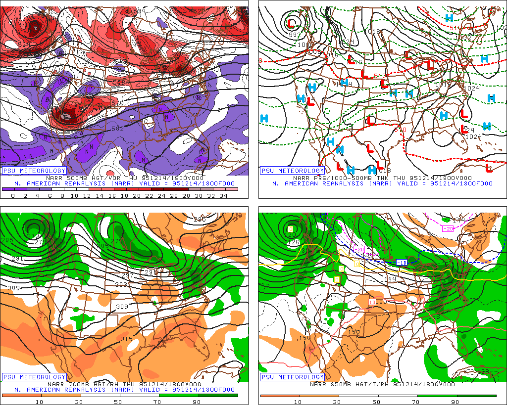
@CoastalWxremember this storm? I was just thinking of this one because the pattern kind of reminded me of it.....if oneof these shortwaves works out, it might look like this....you have this zonal -PNA flow running into a NAO block. http://www.meteo.psu.edu/fxg1/NARR/1995/us1214.php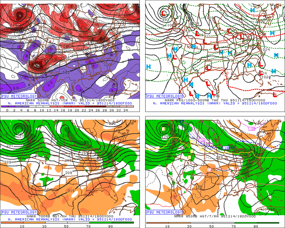
-
December 2021 Obs/Disco...Dreaming of a White-Weenie Xmas
ORH_wxman replied to 40/70 Benchmark's topic in New England
We're bumping this post when you start making optimistic posts at 00z about that system. -
December 2021 Obs/Disco...Dreaming of a White-Weenie Xmas
ORH_wxman replied to 40/70 Benchmark's topic in New England
If we can keep that Xmas eve shortwave just barely robust enough, the midlevel profile is pretty nice for snow growth....you have like -12C temps at 700mb and the SGZ is also pretty deep. -
December 2021 Obs/Disco...Dreaming of a White-Weenie Xmas
ORH_wxman replied to 40/70 Benchmark's topic in New England
Yeah you shift everything eastward a little bit and you will get more storm amplification…but even just something nuanced like a little piece or spoke of the 50/50 PV lobe retrograding and phasing can cause a storm to pop. Something like that won’t been seen on guidance though until way closer. -
December 2021 Obs/Disco...Dreaming of a White-Weenie Xmas
ORH_wxman replied to 40/70 Benchmark's topic in New England
The trough out west has never disappeared on any guidance except maybe clown range on the weeklies a few c HC les ago. It just shifted east slightly….the theme will remain -PNA…maybe we get it closer to neutral deeper in January of the weeklies are right but don’t expect 1977 and 2015 ridges out there.