ORH_wxman
-
Posts
93,092 -
Joined
-
Last visited
Content Type
Profiles
Blogs
Forums
American Weather
Media Demo
Store
Gallery
Everything posted by ORH_wxman
-
“Interior….even into SNE” is going to favor places like N ORH county out to Berkshires. Your interior but pretty far south in context to where NNE/CNE turns into SNE.
-
Yeah I think many will see first flakes from flurries/dying snow showers late next week/weekend…esp over interior if they don’t see them early Wednesday from that system approaching.
-
EPS was sort of siding with keeping the cold through Tday…even if not quite as cold as later next week/weekend. It seems the -EPO evaporates and sort of goes more into a -WPO pattern but there is still some ridging in the AO region.
-
Agreed. H5 anomaly would be way more useful.
-
Got up to 73 here. But right now 67F so slowly starting CAA. As for beyond today, euro pretty close to starting interior as a burst of snow. Mostly N of pike but can’t rule out a few flakes at start south of pike on early Wednesday morning. Euro has a solid advisory event for NNE. Maybe low Tip is also right about the model guidance still being divergent on what happens beyond next weekend. Some try to relax the flow and go to seasonably mild weather (but not epic torch levels like we saw so far this month)…and others like GGEM keep the cold around.
-
That was winters revival in SNE too after a bit of a break with some messier/mix/warmer events in early February. We rebuilt the pack to around 25-27” in ORH during that period after it had been matted down to like a 6-8” glacier. There was a lot of water in the pack by mid March. Luckily it was a very slow melt off with dry weather mostly in late Mar/early Apr.
-
Up there you’ll likely have a few sub-freezing highs.
-
Sure you can try but you’ll look ridiculous if the empirical evidence doesn’t back you up.

-
Shaping narratives is the thing on here the past 5-8 years. We’ll run the numbers when the next 2 weeks is done. My guess is the next two weeks (after tomorrow…so from 11/13-11/26) average well below average temps. Prob somewhere in the -6 to -10 range. You can’t really lie/spin effectively if empirical evidence is opposing your narrative.
-
Is that run off of the KFS or Vice-versa?
-
There’s a chance it trends colder. It’s still 5+ days out. But there’s more ways for it to rain this early so that’s the safe forecast. My guess right now is that if it did start as snow, it would be short lived.
-
There’s a chance is starts as a bit of snow but I’d prob lean against it right now.
-
3 weeks from now that system would prob be a really good SWFE. But prob mostly an NNE event this time and at elevation.
-
Oh for sure. There’s a reason me/Ray/Scooter’s generation used to think 3-6” was an amazing snow event. We grew up in dogshit winters during our formative years. Esp that crucial age 8-12 period.
-
Patriots had snow games in back to back weeks that season. The December 14, 2003 storm was a solid front ender that got them during game time. Then of course the AFC championship game against the Colts was in light snow. A week earlier was like 0F in the divisional round against the Titans. January 2004 cold snaps were epic. Then the next year another snowstorm during the divisional round game against the Colts again. I remember Corey Dillon running all over them in the snow that game.
-
1957 through 1963 was a pretty good period for early December snow in NNJ. Pretty anomalous in the historical record.
-
Pretty hard to get warning snow in November. Even at ORH at 1000 feet. November warning snows at ORH off top of my head since 1985 2018 2014 2012 2002 (2004 did have marginal warning snow southeast of ORH) 1989 1987 6 out of 37 years. Went all of the 1990s without a warning event in November. Did have some solid advisory events though in 1997, 1995, and 1991. Usually there’s a 1-2” event though. I’d be surprised if we don’t get measurable this month given the pattern shown.
-
Nice EPS run....but lets hope the weeklies are wrong in clown range. They show a furnace for December.
-
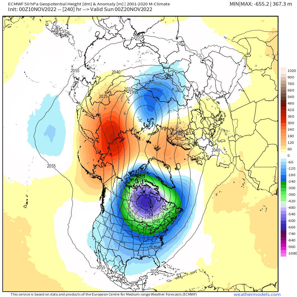
Not sure about the EPS....Scott can post when he sees this, but I do have OP run from last night and it basically splits the PV at 50mb by D10

-
Prob the worst ice storm on record for most of SNE. 2008 may have been worse in N ORH county and near NH border....though even that is up for debate. Certainly further south, 1921 was the worst.
-
November 1921 redux?
-
Yeah the one late next week looks like a needle-threader but even if that one didn’t work out I’d bet on more chances Tday week assuming the pattern being depicted doesn’t change too much.
-
Some threats showing up in the medium/long range which isn’t a huge surprise given the pattern developing. We’ll see if we can actually cash in. I’d be surprised if NNE at least doesn’t but decent chance SNE could see something too.
-
Little ridge bridge trying to show up on the 10-15 day you can see from Brooklynwx99’s post. That helps push those negative anomalies further south into New England. You can bet there would likely be a winter threat or two in that type of pattern even in late November.