ORH_wxman
-
Posts
93,092 -
Joined
-
Last visited
Content Type
Profiles
Blogs
Forums
American Weather
Media Demo
Store
Gallery
Everything posted by ORH_wxman
-
-
Most day 9 potential storms don't work out so it wouldn't be surprising. But who knows...maybe something else breaks favorable like Monday or the 1/11 system comes back from the dead.
-
I actually think it starts looking better again around the 20th. But we'll see.
-
Nice solution for ORH through 495 belt and up into S NH. Even 128 belt metrowest does well later this afternoon....something to watch.
-
Yes, it's good you are snowing now...the other question there is how much QPF you get from the afternoon stuff. The best is prob to your east and northeast, but by how much? Maybe you get an inch this afternoon....or maybe you get 3".
-
Yep....that is the key in this one...if we trend toward less northern stream insert, then we can punt this one to the moon.
-
Looks like around 17z-22z is the best period....this morning's batch is kind of the appetizer but the better lift and soundings look like when that commahead tries to form.
-
Snowing in ORH now. Mixing with snow here but still mostly pingers.
-
Steady sleet just commenced here actually. Assumed it was raining and when I opened door it I could hear all the pingers.
-
The crappy solutions for the 1/14 storm are not inserting much northern stream energy. That is a requirement for the storm to be any good. You don’t want this just cutting off from the polar jet otherwise it turns into a spring storm.
-
10z runs were wild. Should be interesting later today.
-
I think it’s mostly going to be how good the lift is. A lot of those zonked solutions with 4-6” had big omega and big QPF on 3 hour progs. Some of these warmer ones are just a bit more subdued on the dynamics. It’s usually safer to go with the more subdued progs but you always have to keep the zonked ones in the back of your mind when you have an unstable sounding like we have tomorrow.
-
3k is colder than 12k…kind of a flip from 18z
-
Seems like the trend so far at 00z is to take a bit longer for 925 to crash. NAM too just coming in.
-
00z rap is kind of similar.
-
18z euro finally ramped up more with the QPF.
-
If he’s snowing there by mid morning then it’s a good sign for me. I honestly could see a coating or 5”. Not sure yet.
-
I think he told you that 925 is borderline there. It slowly cools as it gets going but initially it’s kind of warm.
-
It will be in your hood.
-
GFS still impressive at 18z. Cooled a bit for the CP in E MA.
-
Weeklies actually look decent for late Jan and early Feb….but we know the caveats. It goes more toward a classic La Niña pattern but with a pretty strong AK ridge which is usually good in February…longer wavelengths tend to make it less likely you get the AK trough folding back and digging in Cabo San Lucas.
-
Yeah I thought you had something in that. I remember 2/13 porking your area. Even in back bay where I was working on 2/13 and it was like 4-5" of total paste but over on the water it was almost nothing. Anyways....should be interesting tomorrow....hopefully there's some really intense bands.
-
No, Feb 2014 was a very cold month. No huge torches that month.
-
Yeah, like the Herpes is compared to the RGEM. Maybe we'll get an obscene 3k solution at 00z tonight.
-
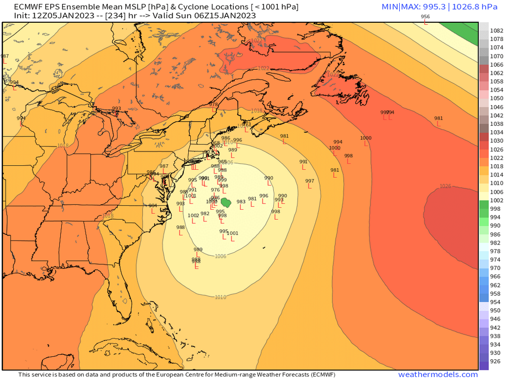
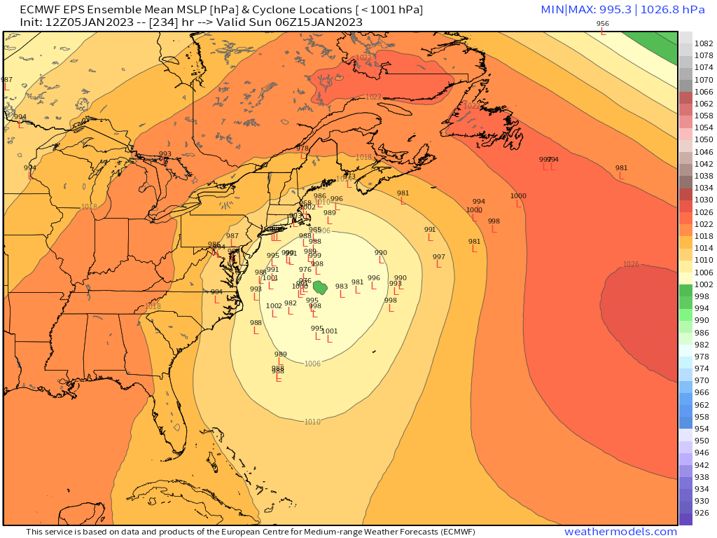
Here's the individual members as it makes the closest pass to the benchmark....we're a long ways out so this doesn't mean a whole lot yet. Unfortunately, I feel like it has to keep being said about D9 progs lest you be accused of implying these are going to verify verbatim (which is kind of impossible when we're posting an ensemble spread....but logic never got in the way of a good internet meme argument).