ORH_wxman
-
Posts
93,092 -
Joined
-
Last visited
Content Type
Profiles
Blogs
Forums
American Weather
Media Demo
Store
Gallery
Everything posted by ORH_wxman
-
Feb 10-11 Mid Week Minor Event - Ride the hot hand?
ORH_wxman replied to HoarfrostHubb's topic in New England
18z ICON and Reggie both looked better and more organized....Reggie did lower that ridiculous WAA stripe across S CT which seemed a little spurious, but the rest of the region juiced up. -
2/16 is kind of a mess on guidance....I'm hedging that something will go wrong on that one, but I do think if it gets near the BM, it will be a good event for most. Cold has been undermodeled and even a degree or 2 will make a good difference for the CP.
-
Feb 10-11 Mid Week Minor Event - Ride the hot hand?
ORH_wxman replied to HoarfrostHubb's topic in New England
NAM gone wild. Not biting on solid advisory yet for here, but 1-3 seems more likely today. Euro still paltry but it's kind of an outlier. It hasn't been great this winter....especially with smaller events. -
Euro skynet is a whiff on the 16th. Hasn’t liked this threat for several cycles.
-
Feb 10-11 Mid Week Minor Event - Ride the hot hand?
ORH_wxman replied to HoarfrostHubb's topic in New England
1-2” and call it a day. Don’t really see more than that unless there’s an enhanced area like Reggie/GFS kind of show further south. -
Feb 10-11 Mid Week Minor Event - Ride the hot hand?
ORH_wxman replied to HoarfrostHubb's topic in New England
Still not great in euro but prob 1-2” northeast of BDL-PVD line. -
Yes it will. Even a week of normal temps will feel very warm considering the last 3 weeks.
-
Feb 10-11 Mid Week Minor Event - Ride the hot hand?
ORH_wxman replied to HoarfrostHubb's topic in New England
18z NAM is still aggressive. Prob advisory amounts for eastern SNE and up into CNE/NNE -
Notice how the shades get lighter as you go closer to northeast coast. Not even sure it will be AN there. Under 50% probability. My guess is it will technically come in AN but not by much. Bush league torch.
-
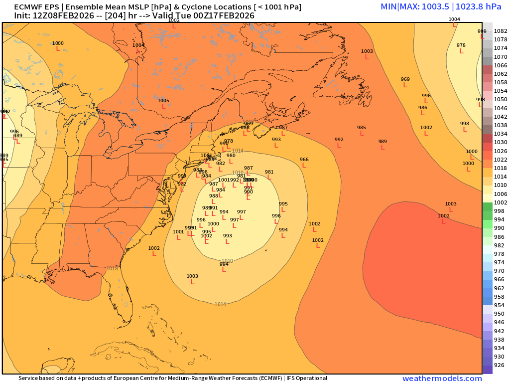
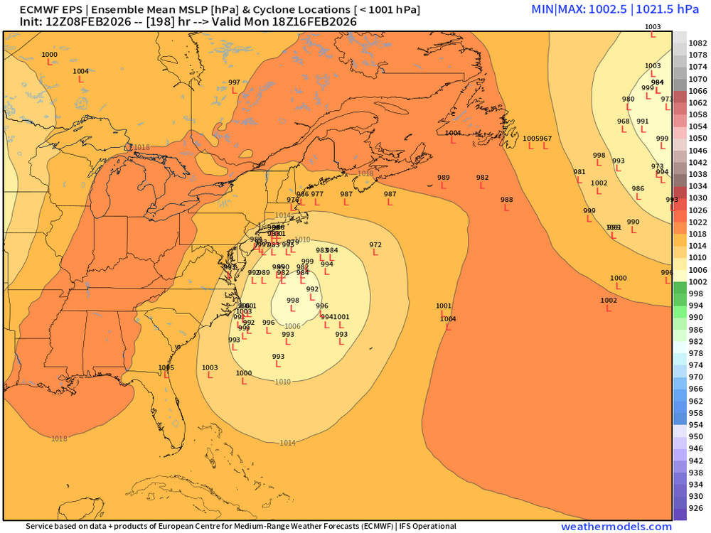
Pretty snowy EPS run overall. Has more chances after the 16th too. Mean is double digits across a lot of New England. It’s not a frigid pattern but it’s just not submitting to the classic Feb Niña torch idea that has been an instinct to gravitate towards for many of us Mets. It’s a real struggle to get sustained large positive departures on these runs. You’ll see a run or two that starts to look like that but then it disappears the next run or even on the same run it can’t last more than a day or two. The in-situ blocking seems to dominate us locally while the plains have an easier time getting big warmth.
-
Plenty of spread but def a lot more potent than yesterday

-
So overnight was doom and gloom….this flips the other way. Been terrible model consistency (including ensembles…we expect OPs to jump a lot) in the medium range since late January.
-
Friday February 6 FROPA / WINDEX small event
ORH_wxman replied to HoarfrostHubb's topic in New England
Yep I’m with @dendrite, I was surprised we didn’t get more 16-20” reports when we had a bunch of 10-13” reports by mid morning. So I’d say that 16” is legit and there’s prob a few more areas that did just good near them but didn’t report. -
Oh so the previous claim of 19 days was incorrect. Still an impressive streak but they won’t be breaking that.
-
What’s AOB 33F? I think the BOS steak doesn’t include 34F.
-
Normally 2015 would’ve blown all this out of the water but we had one day in early February (wanna say 2/5) where we got a light snow event but it started kind of warm. BOS snuck to like 37-38F and ORH got to 34F I remember vividly. Because otherwise I think ORH would’ve gone like 5-6 straight weeks below freezing from second half January until late February that month.
-
ORH has an outside chance of breaking their sub-32F streak too but they’d have to survive a marginal day or two later this week. Don’t think they will but still pretty impressive they have a shot at all. Kind of matches what we’ve all felt…it’s been very consistently solid cold even though the very high-end airmasses have been a little less than you’d expect out of a prolonged cold pattern.
-
BOS threatening their 1918 sub-34F high streak.
-
Yeah that was a brutal one. First week of the month I think ORH set 3 daily records. We had like a 10-12” frozen glacier. Then we finally torched mid month before the cold returned for the St Pattys day storm
-
Yep. Maybe we get a couple cutters or rainers and that’s the beginning of the pack disintegrating but at this point, might as well roll the dice with a milder but more active pattern and try to increase the snow pack with some juicier events. I don’t need highs of 24F and stein watching it sublimate. That would remind me of the 3 weeks after Mid-Feb 2014. That was painful watching such a monster pack just slowly sublimate in the late winter sun every day even though it stayed very cold.
-
Yeah hard to get CAA below 0F temps into SNE after mid February. But I honestly couldn’t care less about that crap….unless it’s really high end where records are threatened. I’ll take moderate temps with lots of chances over deep layer CAA and stein.
-
And that includes ensembles. Literally 2 cycles ago we had a ton of hits on ensembles for next week and most of them evaporate within a run or two. Conversely, we have seen some events come back after losing them (1/18-19 did…AI remained more enthused and was correct)
-
There’s this weird pendulum in here where one group tries to push “end of winter”, “back broken”, etc etc…and then another group that pushes deep winter until 4/1. Let’s just call it what it is…moderation on temps (Second half of February does this most years) but 90% of this forum only cares about snow…so what about snow? Well, next week maybe a light event mid-week and then the weekend remains in limbo. If model performance since late January is any indication, I wouldn’t feel comfortable about saying anything beyond D5-6 right now. It’s been really bad consistency.
-
Friday February 6 FROPA / WINDEX small event
ORH_wxman replied to HoarfrostHubb's topic in New England
ORH used to have that problem. Not as much these days but check out some of their old reports from the 2000s and 2010s. Some of the storms are like 50 to 1 ratios. -
Friday February 6 FROPA / WINDEX small event
ORH_wxman replied to HoarfrostHubb's topic in New England
Yeah unless they change the F6 data then I’d go 5.4. Id prob hedge higher anyway since they had 4.2” at 1pm and got smoked for a while. I thought they’d finish with 6”+.