

ORH_wxman
-
Posts
93,092 -
Joined
-
Last visited
Content Type
Profiles
Blogs
Forums
American Weather
Media Demo
Store
Gallery
Everything posted by ORH_wxman
-
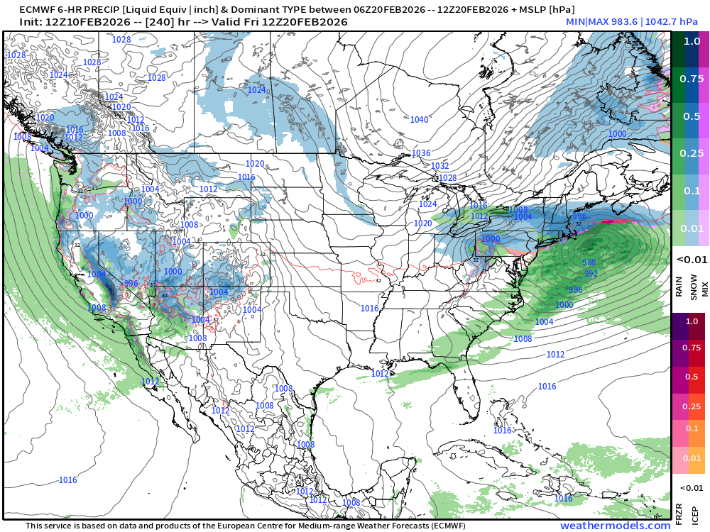
Euro has been significantly blockier in the longer range than the GFS…which is producing wildly different sensible wx for us on those runs. GFS tries to torch us to 60F while euro has multiple winter wx threats.
-
Let’s lock in next Thursday/Friday on euro.
-
Feb 10-11 Mid Week Minor Event - Ride the hot hand?
ORH_wxman replied to HoarfrostHubb's topic in New England
Wonder if this kind of acts like a WINDEX event down here except without the wind since we don’t have low level instability…it’s more elevated above the inversion. You get NW to SE motion on the line of steadier snow and maybe it rips for an hour or two and that’s mostly all you get. -
Feb 10-11 Mid Week Minor Event - Ride the hot hand?
ORH_wxman replied to HoarfrostHubb's topic in New England
It did show north shore QPF enhancement but it was just very light across the board elsewhere on a lot of runs until it was imminent. A lot of runs showed less than a couple tenths here. -
Feb 10-11 Mid Week Minor Event - Ride the hot hand?
ORH_wxman replied to HoarfrostHubb's topic in New England
I think both hrrr and rap have been mostly horrific this winter but they do have some utility typically in shorter term forecasts. Hrrr was dreadfully too dry in the IVT a few days ago. Rap being paltry though worries me a little more because usually rap goes a little wild on QPF. -
Feb 10-11 Mid Week Minor Event - Ride the hot hand?
ORH_wxman replied to HoarfrostHubb's topic in New England
Hrrr soundings keep it very dry below 900mb even during the convective stuff so the QPF output is really paltry even though the sim radar shows like 25-30dbz snow bands. Haven’t seen that in most other guidance. -
I’d still think this longwave look should’ve produced at least one or two solid coastals. Only fly in the ointment is you can see the western ridge getting sliced off a bit in Canada, we know at least a couple systems failed on us because we couldn’t quite amplify it enough out west. But even with that showing up minorly in the mean, it’s still surprising we didn’t pop at least a miller B or two.
-
Feb 10-11 Mid Week Minor Event - Ride the hot hand?
ORH_wxman replied to HoarfrostHubb's topic in New England
There’s def a convective element to the stuff after that initial thin leading band. ML lapse rates are actually pretty high. I think whoever gets a quasi-stationary convective banding element for a couple hours is where you could see a 3-4” surprise. Otherwise if you are outside that, prob a 1-2” deal. -
Yeah that 1/25 storm would’ve tried to cut into BUF with that flow buckling out in the Rockies …good thing we had that faster flow to keep it south of us.
-
Skynets may have sniffed out this one not being amplified enough.
-
Feb 10-11 Mid Week Minor Event - Ride the hot hand?
ORH_wxman replied to HoarfrostHubb's topic in New England
Let’s put it this way, if this ends up as widespread 4-6” over eastern regions, this winter will be making some headway continuing to stay ahead of the chains. -
Feb 10-11 Mid Week Minor Event - Ride the hot hand?
ORH_wxman replied to HoarfrostHubb's topic in New England
GFS got juicier again. -
Feb 10-11 Mid Week Minor Event - Ride the hot hand?
ORH_wxman replied to HoarfrostHubb's topic in New England
Yeah I saw a decent amount of crosshair sig. pretty cold soundings overall for a storm coming from this direction. Wonder if the sludgy low level cold that has seemed to entrench over New England is helping juice this a little bit. Forcing a little more lift on the WAA. -
Feb 10-11 Mid Week Minor Event - Ride the hot hand?
ORH_wxman replied to HoarfrostHubb's topic in New England
Yeah. But then again we seem to be overperforming on minor events. If it rips hard for 3 hours, you can overperform. -
Feb 10-11 Mid Week Minor Event - Ride the hot hand?
ORH_wxman replied to HoarfrostHubb's topic in New England
Reggie juiced up a decent amount for a lot of eastern SNE. -
Feb 10-11 Mid Week Minor Event - Ride the hot hand?
ORH_wxman replied to HoarfrostHubb's topic in New England
I think 1-3” is prob the best forecast at the moment down in the pike region. We are relying on like 3 hours of WAA precip. -
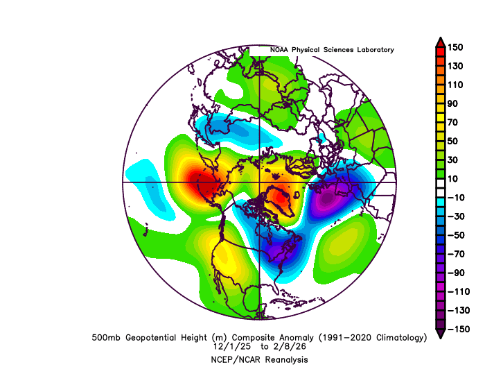
Both 2003-2004 and 2002-2003 were about 0.4F behind at this point. Still quite cold but tied for 23rd while this year is tied for 17th
-
Feb 10-11 Mid Week Minor Event - Ride the hot hand?
ORH_wxman replied to HoarfrostHubb's topic in New England
Yeah it is still the best model. But as we’ve said so many times, it isn’t just the utterly dominant force relative to other guidance that it was in the 2000s/2010s. The gap has been closed some. The way you know deep down it’s still the best is that every single person here if they had to pick a model to be on an island showing the solution they want, they’d still pick the euro. Nobody is picking any other global model to be on an island in the medium range. -
Feb 10-11 Mid Week Minor Event - Ride the hot hand?
ORH_wxman replied to HoarfrostHubb's topic in New England
Euro still seems to win on the synoptic features, but it's been struggling with smaller stuff and QPF placement on some of these events. -
Feb 10-11 Mid Week Minor Event - Ride the hot hand?
ORH_wxman replied to HoarfrostHubb's topic in New England
18z Euro is starting to blow up the WAA too, but it's doing it a little late. My guess is it will start doing it earlier and earlier with each cycle. It also had that little weenie band down in S CT like the RGEM had at 12z, but it wasn't nearly as wild with the qpf as that RGEM run. -
I’m not worried about sfc temps for most…it’s the midlevels. But still a ping ways out. A whiff south is still a concern.
-
Feb 10-11 Mid Week Minor Event - Ride the hot hand?
ORH_wxman replied to HoarfrostHubb's topic in New England
GFS juicing up a bit too at 18z....Really likes Ray's area up into SE NH, but it got better for all of SNE vs 12z. -
Coldest start at ORH too since 1995-96 at this point. The two years immediately ahead of 2026 are 1976 and 1996 and both were quite torchy around 2/9-11 so we actually might pass those two over the next few days even though we're not going to be particularly frigid....today's number will be pretty cold though which aren't in the books yet.
-
Feb 10-11 Mid Week Minor Event - Ride the hot hand?
ORH_wxman replied to HoarfrostHubb's topic in New England
RGEM was the first to really pick up on the WAA snows in this one just as it was the first (and most consistent) in showing the north shore jackpot in Saturday's event. I've been pretty impressed with the RGEM performance this winter....lets see if it can be correct here as well. Doesn't mean no hiccups (I think that stripe of warning snowfall jusyt N of the merritt was prob a hiccup on 12z run, but otherwise it's been liking the general WAA enhancement after that initial thin band....and other model guidance has slowly caught on except for the stubborn Euro) -
Friday February 6 FROPA / WINDEX small event
ORH_wxman replied to HoarfrostHubb's topic in New England
It;s the site of the old KNZW airbase....it used to have manned obs in the early to mid 1990s before closing. It's almost in Abington on the town line IIRC....and yeah, just due west of Norwell.


