

ORH_wxman
-
Posts
93,092 -
Joined
-
Last visited
Content Type
Profiles
Blogs
Forums
American Weather
Media Demo
Store
Gallery
Everything posted by ORH_wxman
-
Has nothing to do with what I said though....I've banging the "suppressed risk" for a couple days now on 1/6. But it is still hilarious to watch people live and die on model PBP at such a ridiculous lead time.
-
Oh you know people are taking these OP runs fairly seriously. It's quite evident in the discourse.
-
It would be another 55F rainstorm if we didn't have the NAO. Just need to avoid having too much block which is definitely a risk right now.
-
Lots of very marginal events where elevation helped the last couple winters.
-
ORH has had a few shaft jobs the past winter or two too even in storms that hit areas nearby. Feels like they are getting some payback for this 6 winter stretch....that's actually a ridiculous stretch relative to climo (about 70" long term mean).
-
Interior SE NH like 20 miles north of you might be even worse relative to climo, but that whole area from like Reading, MA to Epping/Deerfield, NH has been screwed badly.
-
NE MA and SE NH is overdue for some big events. All of New England has had it relatively rough the past 5-6 seasons in aggregate, but that area is a pretty decent snowfall climo area that has been shafted worse than most spots relative to climo. It has been the lack of SWFEs and late blooming Miller B storms that is probably the biggest culprits. Those are the ones they clean up on.
-
Yeah it's my only AN snowfall season since 2017-18. Boston and the immediate coast had AN snow in 2021-22 but nobody west of them did.
-
2020-21
-
Didn't you watch the Terminator and Terminator 2 years ago? Skynet is the AI computer that becomes self-aware and tries to destroy humanity.
-
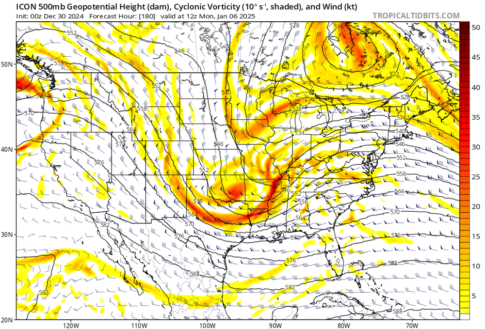
Not on that depiction but it would probably be a monster storm if we had another few panels. There’s a lot of ways for that storm to work but there’s definitely a meat-grinder/suppression risk too. That’s my biggest concern looking at overnight guidance. That block is a pig. On one level, that block is very likely preventing 1/6 from being a big cutter…the 1/6 shortwave is amplifying quickly out in the plains which wound surely send the system into Ontario without any Atlantic confluence or blocking. But too much of a good thing is a possibility.
-
Lets go with the ICON solution of the block pinning part of the PV and then doing a partial PV phase with the main shortwave
-
OP Euro was a near-miss next Monday. But yeah, they are close....EPS is more amplified and gets precip into most of the region. My biggest concern is still suppression on these....the block in the NAO region is really strong and it's the type of setup where we've seen suppression in the past.
-
EPS is still fairly amplified for 1/6…and while there’s timing differences that overlap somewhat, there’s still two distinct event signals on the ensembles. 1/6-7 and 1/10-11…fairly similar to what we’ve been seeing on both Euro and GFS OP runs with two storms.
-
Yeah that was an impressive month. CT was ground zero but we all had our own jackpots I feel like. Ground zero started in CT but then it moved northeast it felt like….CT jackpotted in the 1/12 HECS and the norlun on 1/7-8. Your area jackpotted in the sneaky clipper/redeveloper on 1/21/11 and did well in the front ender on 1/18/11…then of course there was 1/27 which destroyed eastern half of SNE and you did really well again in the 2/1-2/2 storm.
-
December 2024 - Best look to an early December pattern in many a year!
ORH_wxman replied to FXWX's topic in New England
We have a bunch in one of the nature preserves in Hopkinton near us, but all the saplings split open once they grow large enough. It’s weird how the trees are totally fine until they get to a certain size. -
That longwave pattern is so dominant that it really wants to spawn something near the coast. I think we just need to avoid super blocks bullying their way too far south…which would be my biggest “concern” at the moment.
-
December 2024 - Best look to an early December pattern in many a year!
ORH_wxman replied to FXWX's topic in New England
Is that a blight-resistant American Chestnut? If not, being isolated like that might help it survive. -
GFS run gets the job done in a wonky way (the 1/6 system getting ground up sort of leaves of baroclinic zone nearby so 1/8 amplifies) but that is good example of how this pattern can produce in different ways. The dice are loaded in our favor which gives lots of ways to succeed. You treat the OP runs as a single ensemble member at this point. The Op run won’t become more important until we’re prob inside of D5/6.
-
We’ll have the entire forum pitch in and give you the consolation prize if we get 1985’d

-
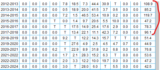
Yes I remember seeing pics of from NS and NF in the ne.weather group that winter. As epic as that winter was in N ORH county and interior S NH, it was like different planets compared to NS and NF. They just got completely buried that winter. Prob like a once per century type deal for them. Some pics had pretty good evidence of 7-8 foot snow depths on the level.
-
White Snake is calling you. You can hear the slamming on his guitar to “Jan ‘85! Jan ‘85!”
-
Excessive cold into the Deep South with extremely high anomalies in both PNA region and NAO region is def giving me Jan ‘85 vibes. Hopefully it ends up amplifying and not a Deep South and Mid-Atlantic CJ
-
Because it really hasn’t been unwavering. There were some runs giving interior MA a paste job or close to it a couple days ago. We just don’t notice the oscillations when it’s the difference between 35F rain or 39F rain or 44F rain. There’s been some pretty big sensible wx differences for NNE on some of these runs. Like 6-10” of paste or just cold rain with some catpaws.
-
Block presses too far south into Hudson Bay this run for the Mar ‘93 redux. But man, that is just a huge hemispheric longwave signal around 1/10.


