ORH_wxman
-
Posts
93,055 -
Joined
-
Last visited
Content Type
Profiles
Blogs
Forums
American Weather
Media Demo
Store
Gallery
Everything posted by ORH_wxman
-
OP Euro was a near-miss next Monday. But yeah, they are close....EPS is more amplified and gets precip into most of the region. My biggest concern is still suppression on these....the block in the NAO region is really strong and it's the type of setup where we've seen suppression in the past.
-
EPS is still fairly amplified for 1/6…and while there’s timing differences that overlap somewhat, there’s still two distinct event signals on the ensembles. 1/6-7 and 1/10-11…fairly similar to what we’ve been seeing on both Euro and GFS OP runs with two storms.
-
Yeah that was an impressive month. CT was ground zero but we all had our own jackpots I feel like. Ground zero started in CT but then it moved northeast it felt like….CT jackpotted in the 1/12 HECS and the norlun on 1/7-8. Your area jackpotted in the sneaky clipper/redeveloper on 1/21/11 and did well in the front ender on 1/18/11…then of course there was 1/27 which destroyed eastern half of SNE and you did really well again in the 2/1-2/2 storm.
-
December 2024 - Best look to an early December pattern in many a year!
ORH_wxman replied to FXWX's topic in New England
We have a bunch in one of the nature preserves in Hopkinton near us, but all the saplings split open once they grow large enough. It’s weird how the trees are totally fine until they get to a certain size. -
That longwave pattern is so dominant that it really wants to spawn something near the coast. I think we just need to avoid super blocks bullying their way too far south…which would be my biggest “concern” at the moment.
-
December 2024 - Best look to an early December pattern in many a year!
ORH_wxman replied to FXWX's topic in New England
Is that a blight-resistant American Chestnut? If not, being isolated like that might help it survive. -
GFS run gets the job done in a wonky way (the 1/6 system getting ground up sort of leaves of baroclinic zone nearby so 1/8 amplifies) but that is good example of how this pattern can produce in different ways. The dice are loaded in our favor which gives lots of ways to succeed. You treat the OP runs as a single ensemble member at this point. The Op run won’t become more important until we’re prob inside of D5/6.
-
We’ll have the entire forum pitch in and give you the consolation prize if we get 1985’d

-
Yes I remember seeing pics of from NS and NF in the ne.weather group that winter. As epic as that winter was in N ORH county and interior S NH, it was like different planets compared to NS and NF. They just got completely buried that winter. Prob like a once per century type deal for them. Some pics had pretty good evidence of 7-8 foot snow depths on the level.
-
White Snake is calling you. You can hear the slamming on his guitar to “Jan ‘85! Jan ‘85!”
-
Excessive cold into the Deep South with extremely high anomalies in both PNA region and NAO region is def giving me Jan ‘85 vibes. Hopefully it ends up amplifying and not a Deep South and Mid-Atlantic CJ
-
Because it really hasn’t been unwavering. There were some runs giving interior MA a paste job or close to it a couple days ago. We just don’t notice the oscillations when it’s the difference between 35F rain or 39F rain or 44F rain. There’s been some pretty big sensible wx differences for NNE on some of these runs. Like 6-10” of paste or just cold rain with some catpaws.
-
Block presses too far south into Hudson Bay this run for the Mar ‘93 redux. But man, that is just a huge hemispheric longwave signal around 1/10.
-
The confluence is extremely strong. Nitpicking, but we’d like to see the PVA a little further east to keep the best dynamics intact but at D8 it’s a totally trivial point.
-
Looks like those were two weeks apart…so according to DIT that definitely classifies as back to back. Very rare.
-
Lol Jeff Smith and I were going nuts over that one. Freshman year at Cornell but we weren’t back from winter break yet…but we were IMing eachother the NGM and ETA outputs the night before. He was down in Plymouth, MA…for a brief moment it was looking like an epic blizzard of the century for immediate coastal MA. The problem back then was the Euro only came out once a day…12z run but not until like 8pm at night, lol. So when you were viewing 00z runs, you always had in the back of your mind, “I wonder if the Euro will say anything remotely similar tomorrow”.
-
There was a storm I recall that went into the upper 940s in January 2000…wanna say it was 1/21/00….the old NGM model the day before the event backed it close enough that it was giving 4” of QPF to E MA coast and Harvey Leonard started honking. ETA was trending west too but not quite as crazy…but still big QPF. The NGM was usually dry-biased so it was eye-popping to see those numbers. It ended up scooting east and just scraped us with a few inches. I think the storm annihilated Hazey’s area in Nova Scotia. Thankfully the forecasts never got too crazy because I think the 12z models the next day did shift it back east some so it was really just that one 00z run the day before.
-
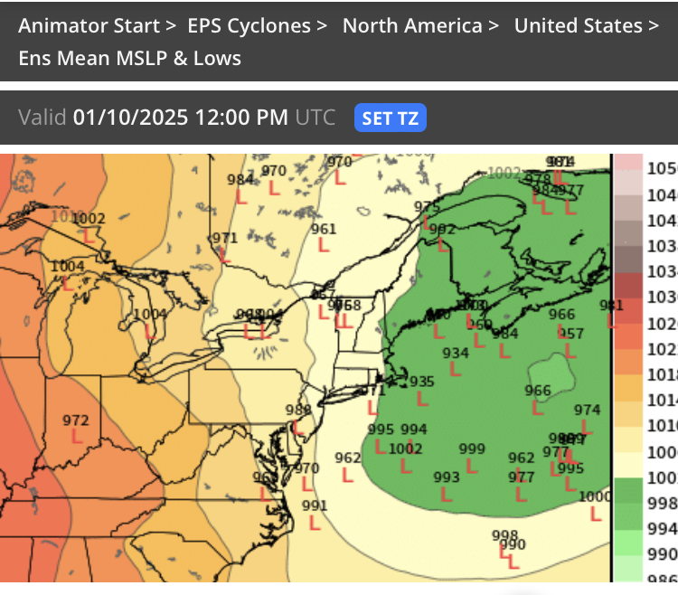
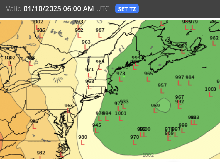
Lot of timing differences at that range so it’s fun to keep looking at different panels. Here’s another with two different 930s, lol.
-
Storms that are 3-4 days apart isn’t that rare. If it’s like 1-2 days apart it’s much harder to do.
-
Let’s see if we can get a 933 over the benchmark
-
Yeah it’s 1/6 and then maybe 1/9-1/10 on that big one. Both systems are quite distinct on the ensembles too.
-
I think Feb 2015 was -13 here. Dec ‘89 was -14 I think. Ironically with all the completely insane warmth, we haven’t had a warm anomaly month beat those. Dec 2015 came close. I think it was +10 or +11. But that’s actually kind of typical of climatology here. The median month tends to be higher than the mean.
-
I’m guessing about 25-30% of the forum is subconsciously using it as a baseline for expectations.
-
Oh the whiners will come out at 00z when the OP run shows it out to sea or jackpotting the Cape.
-
What an absolutely horrific looking pattern over the CONUS. Look at that…looks like late April