Torch Tiger
-
Posts
13,397 -
Joined
-
Last visited
Content Type
Profiles
Blogs
Forums
American Weather
Media Demo
Store
Gallery
Everything posted by Torch Tiger
-

March 2022 Obs/Disc: In Like a Lamb, Out Like a Butterfly
Torch Tiger replied to 40/70 Benchmark's topic in New England
RIP. very good player and overcame stage freight to do what he did every night -
March 2022 Obs/Disc: In Like a Lamb, Out Like a Butterfly
Torch Tiger replied to 40/70 Benchmark's topic in New England
didn't look at the high, but was 61.1 around 4pm. -
March 2022 Obs/Disc: In Like a Lamb, Out Like a Butterfly
Torch Tiger replied to 40/70 Benchmark's topic in New England
Lawson's has some really good stuff. -
March 2022 Obs/Disc: In Like a Lamb, Out Like a Butterfly
Torch Tiger replied to 40/70 Benchmark's topic in New England
Sneaky nice day today -
March 2022 Obs/Disc: In Like a Lamb, Out Like a Butterfly
Torch Tiger replied to 40/70 Benchmark's topic in New England
It's easier to root for record cold when it isn't below zero. Hope for some damaging cold -
March 2022 Obs/Disc: In Like a Lamb, Out Like a Butterfly
Torch Tiger replied to 40/70 Benchmark's topic in New England
Kiss wasn't hard rock/metal in the 80's (after Creatures of the Night)...remember they had Desmond Child and even Michael Bolton (lol) writing their songs. Either way some of the worst music by Kiss and of the era -
March 2022 Obs/Disc: In Like a Lamb, Out Like a Butterfly
Torch Tiger replied to 40/70 Benchmark's topic in New England
Kiss made probably 5 of the top 20 worst albums of the 80's lol -
March 2022 Obs/Disc: In Like a Lamb, Out Like a Butterfly
Torch Tiger replied to 40/70 Benchmark's topic in New England
Yeah possible even probable, just trying to look at the positive (if there is any) -
March 2022 Obs/Disc: In Like a Lamb, Out Like a Butterfly
Torch Tiger replied to 40/70 Benchmark's topic in New England
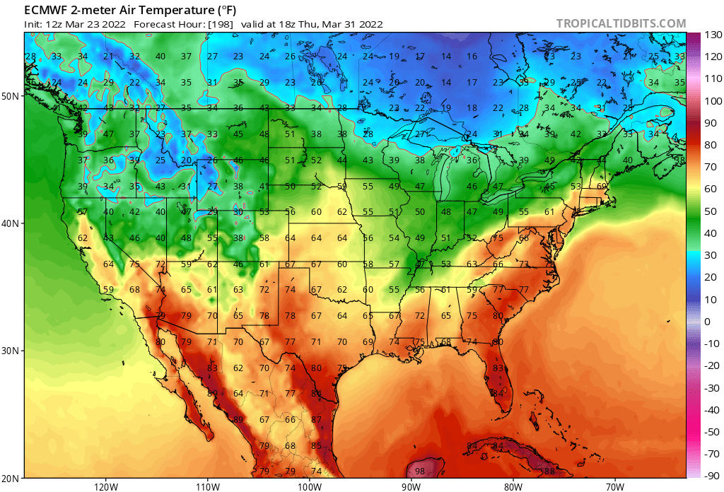
12z GEM and Euro sector us on the 31st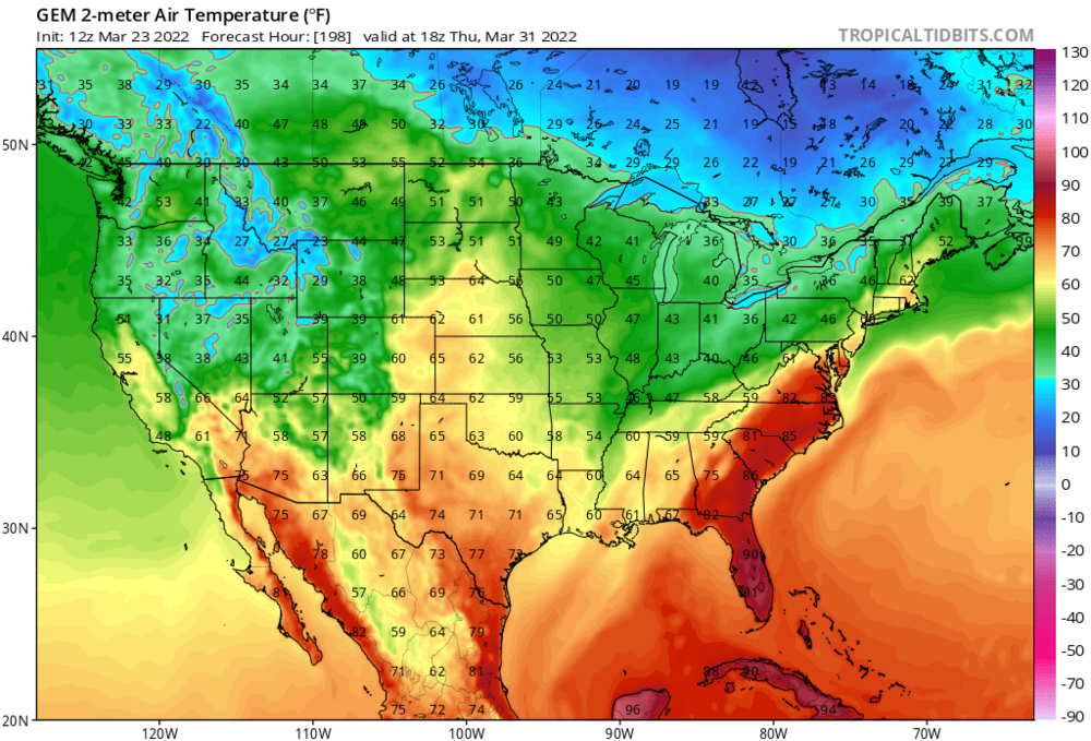
-
March 2022 Obs/Disc: In Like a Lamb, Out Like a Butterfly
Torch Tiger replied to 40/70 Benchmark's topic in New England
if if's going to be cold, let's go all out with some damage. Hopefully we go below zero later in April -
Yeah I realize that, what a torch
-
March 2022 Obs/Disc: In Like a Lamb, Out Like a Butterfly
Torch Tiger replied to 40/70 Benchmark's topic in New England
wasn't trolling, and I'm on the cold/chit train for the record. I simply pointed out massive differences in operational models and people jump on some dumb witch hunt -
March 2022 Obs/Disc: In Like a Lamb, Out Like a Butterfly
Torch Tiger replied to 40/70 Benchmark's topic in New England
Broken spirts, even mets. Hate to see it -
March 2022 Obs/Disc: In Like a Lamb, Out Like a Butterfly
Torch Tiger replied to 40/70 Benchmark's topic in New England
I only said there were major differences between the D10 operational GFS and EC. Yikes... -
March 2022 Obs/Disc: In Like a Lamb, Out Like a Butterfly
Torch Tiger replied to 40/70 Benchmark's topic in New England
This is a "warm" point, folks. Ignored :"( -
that is fascinating
-
March 2022 Obs/Disc: In Like a Lamb, Out Like a Butterfly
Torch Tiger replied to 40/70 Benchmark's topic in New England
Nice evening out there, can't complain for 3/21 -
March 2022 Obs/Disc: In Like a Lamb, Out Like a Butterfly
Torch Tiger replied to 40/70 Benchmark's topic in New England
brrr -
March 2022 Obs/Disc: In Like a Lamb, Out Like a Butterfly
Torch Tiger replied to 40/70 Benchmark's topic in New England
What a night/day difference between D10 12z Euro op and GFS op -
March 2022 Obs/Disc: In Like a Lamb, Out Like a Butterfly
Torch Tiger replied to 40/70 Benchmark's topic in New England
Another great day out there! 59.2 -
Saturday, March 19, 2022 Elevated Convection w/Severe Potential
Torch Tiger replied to weatherwiz's topic in New England
looks light, and mostly west of I91 -
March 2022 Obs/Disc: In Like a Lamb, Out Like a Butterfly
Torch Tiger replied to 40/70 Benchmark's topic in New England
10' lasagna -
March 2022 Obs/Disc: In Like a Lamb, Out Like a Butterfly
Torch Tiger replied to 40/70 Benchmark's topic in New England
Yeah it's an ugly look to end March. Hopefully we can sneak in a few decent rain-free seasonably mild days. -
March 2022 Obs/Disc: In Like a Lamb, Out Like a Butterfly
Torch Tiger replied to 40/70 Benchmark's topic in New England
we just had the first torrential downpour of the warm season. Is that better? -
March 2022 Obs/Disc: In Like a Lamb, Out Like a Butterfly
Torch Tiger replied to 40/70 Benchmark's topic in New England
summer-like downpour... winter's definitely done