

Ruin
-
Posts
918 -
Joined
-
Last visited
Content Type
Profiles
Blogs
Forums
American Weather
Media Demo
Store
Gallery
Posts posted by Ruin
-
-
wait wait wait what? so does it pump snow back into our area harrisburg lancaster all that time?
-
3 minutes ago, Superstorm said:
Staring to fill in now.
On the NAM it looks like a complete stall.
.maybe i shouldnt say frames but hours for the stall?
-
how many frames does she stall for?
-
God dang the precip field better fill in. how about movement speed does it slow down more?
-
10 minutes ago, Superstorm said:
NAM looking good
can you post? also when will we see the precip field fill back in?
. -
10 minutes ago, Superstorm said:
. -
what name are you talking about latest run from last night? or new one I always get the times confused on model runs.
-
I have 5.25 just outside harrisburg. It never really stopped snowing all day just got a tad lighting. All day I had pretty big flakes tho.
-
1 minute ago, basehore said:
If you wanted me to guess... it’s day drinking
") imagine day two and three of this event!
imagine day two and three of this event!
lol
-
at what point does a 10 to 1 ratio go higher? im down to 23 atm. im thinking atm I may be up to a 12 to 1
-
2 minutes ago, Blizzard of 93 said:
No, the 18z Euro delivered a great amount of precip & snow for the coastal tomorrow into Tuesday am for most of us

Oh ok cause that one frame on the gif looked like it was coming up last showing like 1.3 guessing it was first and I was wrong thanks,
-
at what point does a 10 to 1 ratio go higher? im down to 23 atm. im thinking atm I may be up to a 12 to 1
-
Yeah Im in that room atm cause its more active I have no idea why people are getting so testy
-
3 minutes ago, BlizzardNole said:
Intensity is typically tied to visibility, with heavy snow being visibility of less than a quarter mile. I think of heavy snow as about 1 inch per hour. Not necessarily flake size as sometimes you can have large wet flakes but spaced way apart.
Get this -- NYC could see rates of 2-4 inches at times. Man to see that.
Oh thanks
-
wait is the euro now trying to say south central PA gets almost nothing from this coastal?
-
im surprised the precip field isnt farther northwest since its getting tucked in more.
-
 2
2
-
-
Just now, haudidoody said:
Try that here and you'll get banned.
Although it's historically the best approach to forecasting. 95% historical experience and probabilities, 5% guidance
Thats true I heard old timers say that in weather all the time. but the new crop of meteorologists will use %90 of models and they live and die by it. If a model shows ots they hug it. if a model shows up the coast oh its to early to know if it still goes ots. if a model calls for 1-3 they hug it if a model shows 12-18 inchs they are like hold your horses.
-
4 minutes ago, HighStakes said:
Dropped to 24.
nice my forecast high was 36 then 34 never go past 28. currently down to 23 low was forecasted to be 26.
-
2 minutes ago, SnowDreamer said:
idk what "future radar" you're using, but there's a 99% chance it's total crap. Most apps/sites that use "future radar" are HORRIBLE.
accuweather and intilicast. Yeah i wasnt sure how good or bad those radars are when they do future radar's
-
hmmm just took a look at current and future radar and the future radar isnt showing anything like the models are showing for tomorrow
 Myabe it hasnt been updated yet?
-
Just now, SnowDreamer said:
I think of it more like liquid equivalent. Heavy snow=more QPF. Flake size is related to a lot of things like temperature and lift and tends to be good in heavy snow, but it's just a different thing. than heavy/light IMO
ah ok ty
-
So I have to ask when the weather service calls for heavy snow is it the size of the flakes? or is it the rate in which it falls? or can it be both?
-
 1
1
-
-
just wait for the primary to take over and throws back the snow and precip shield grows a bit
-
never heard of this site before but has a pretty cool looking future radar https://www.iweathernet.com/interactive-radar


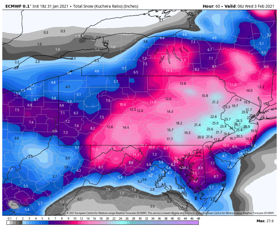
Central PA - Jan 31 to Feb 2 Winter Storm
in Upstate New York/Pennsylvania
Posted
so about 10 tuesday shocked face it goes from mon night ending to 3 am now to like 10am lol omfg.