

Cary67
-
Posts
1,572 -
Joined
-
Last visited
About Cary67

-
Post designed for Maxim(um) effect and Maxim(um) damage
-
Snow mixed with rain in Rolling Meadows about 7pm this evening. Fought it off with a cigar and firepit though.
-
AI usually has animals portrayed with some ridiculous human theme.
-
After last August don't want anymore of these moments
-
Grass is threatening to be mowed,streaks of warmer days, fewer days regressing back to the 30s and 40s. Tulips emerging..signs real spring is here and pseudo spring is coming to an end. About 4 weeks to enjoy upper 50s to mid 70s weather before the switch flips to summer late May.
-
Entering not so blessed climo time. Although on nice warm spring days that NE lake breeze hits late afternoon out here
-
Lower 30s snow wise? RFD escaped sub 30 club barely with latest March snowfalls totalling 6.8". Although areas around RFD received more from blizzard in the 7-10" range.
-
That's surprising. I'm guessing 2 maybe 3" here but will wait to see snow totals around the area.
-
Ready for 1" here and 7" in Harvard. This is RFDs chance to escape the sub 30 club
-
After Dec.8th been living on the margins all winter
-
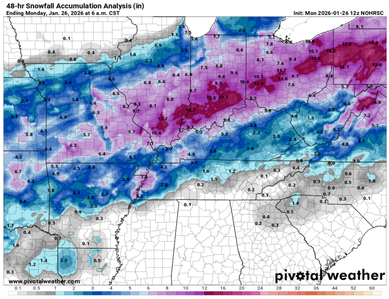
N.IL snow totals

-
If only winter storms here were as reliable as tornados
-
Dusting part 10

-
Think it means, "Trying too hard."As in reverse psychology posting it won't snow here,ergo it will.
-
Winter 2025-26 Medium/Long Range Discussion
Cary67 replied to michsnowfreak's topic in Lakes/Ohio Valley
Dusters part 10 and 11 still on the table.


