-
Posts
1,313 -
Joined
-
Last visited
Content Type
Profiles
Blogs
Forums
American Weather
Media Demo
Store
Gallery
Posts posted by NYCweatherNOW
-
-
43 minutes ago, bluewave said:
It looks like the models are going for forcing in the MJO 6 and 1- 2 regions the next few weeks. So we’ll have to see what that combination looks like in the actual pattern. Plus the +AAM spike gets added to the mix. So a continuation of La Niña and El Niño influences which shows up in the split flow.
By next week we should have something really interesting with decent airmass and +pna and a nice ridge out west should produce for us next week in my opinion
-
 1
1
-
-
5 minutes ago, Snow88 said:
Every model ensemble show a better pattern for the start of February.
Another head fake or finally a true change ?
It’s coming! You seen yesterday’s euro control?
-
 1
1
-
 3
3
-
-
On 1/21/2020 at 3:10 PM, Allsnow said:
For costal sections and the metro area it has 1 inch total for the next 15 days. So yeah, close the shades until further notice
Did you see the euro control ?
-
 1
1
-
 1
1
-
-
17 minutes ago, Ginx snewx said:
10 bucks a month, 33 cents a day. 3 dunkin donut coffees. Why in Gods name would you want the control run anyways.
Cause I heard it was a weenie run. I’m just going to make an account if that cheap and cancel in april thank you guys
-
 2
2
-
-
Just now, Ginx snewx said:
Subscribe to weathermodels.com
I don’t have money like that I was asking for a favor
-
Does anyone have the euro control from 12z?
-
Does anyone have the euro control from 12Z?
-
 1
1
-
-
What did I miss today? I forgot my phone at home and didn’t track? Any potential for next week cause I seen saturdays storm it’s gone!
-
It’s dead jimmy
-
 2
2
-
-
GEFS?
-
5 minutes ago, Snow88 said:
Yes
ULL going north is bad news for the coast right?
-
-
-
Just now, CoastalWx said:
Of course the only thing missing is 5-8” QPF, severe coastal flooding, and hurricane force winds.
What’s up with the eps any change?
-
4 minutes ago, ORH_wxman said:
Basically what dec '92 did except a bit further south. Had the original sfc low tucked in over SE NJ but a secondary was spawning out southeast of the islands.
With that high position though we prob know the interior will be a bit more backed than a model like the GFS says.
What day was that I was trying to look that up?
-
47 minutes ago, Enigma said:
EPS is a nothing burger. Takes the SLP into PHL. Coastal plan gets inundated with wind and high surf.
I was just showing that the eps has a favorable track. If this takes a benchmark track and it’s a bit stronger than some of the models are showing it will snow down to the coast.
-
 1
1
-
-
-
2 minutes ago, NEG NAO said:
still a chance that all the confluence up in eastern Canada will help develop stronger high pressure at the surface and model runs are trending south with LP both at 850 and the surface so this is still a work in progress for the weekend - dynamics - track and the development of HP to the north will determine rain versus snow in the metro area - chance it could start as rain and then transition to snow IMO
What’s cool about this event is it’s still about 6 days away and it’s supposed to be a long lasting event!!
-
 1
1
-
-
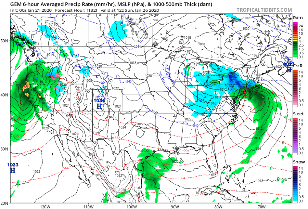
This isn’t over for New York City but the burbs look like the prime spot. Definitely a more long lasting event coming up with this.
gfs has 36 hours of precip
-
 2
2
-
-
1 minute ago, CoastalWx said:
Intensity is sort of irrelevant. It’s timing the ULL along with confluence to the north to help funnel in colder air. What you don’t want, is the euro op. It gets too close and wraps in marine air.
Oh ok... hopefully we trend towards that. It’s a slow moving system this would crush everybody if the hit was maximized
-
Just now, CoastalWx said:
The euro is like a March 2010 catpaw reminder. Putrid airmass on the model. The EPS did look colder.
We need this storm to get a little stronger, the airmass is marginal but if this storm drops say into 985-990 millibar range it’s going to really out the marginal airmass and produce snow even to the coast with the GFS track.
-
1 hour ago, Nibor said:
Well then.
At least I got one out of two I guess. I feel like these games are rigged
-
2 minutes ago, Metasequoia said:
Much better website for EURO.
I use tt for fast track. Euro was close to something but kicked out East real quick.
-


January 2020 General Discussions & Observations Thread
in New York City Metro
Posted
As long as it won’t be the warmest my life is complete!