

Snowcrazed71
-
Posts
1,837 -
Joined
-
Last visited
Content Type
Profiles
Blogs
Forums
American Weather
Media Demo
Store
Gallery
Posts posted by Snowcrazed71
-
-
30 minutes ago, CT Rain said:
I think it still looks pretty good for you guys and most of S CT
But not so much anymore just west of Hartford. Wow.... What a disappointment ( not your fault of course )
-
I don't know guys. A lot of you are saying toss the euro. Throw it out. It's a horrible model. But what if it's right? We've had a couple of instances in past years where it looked like we were going to get a big storm and at the last minute it sneaked away. I hope it's wrong, because I think we're all looking forward to this lol
-
7 hours ago, H2Otown_WX said:
We March '03?
I was looking it up but didn't see anything. How was March 2003?
-
19 minutes ago, Damage In Tolland said:
Replica of 12z
Actually, we gained a little bit more with the 18z over the 12Z
-
 1
1
-
-
3 minutes ago, Snowcrazed71 said:
How much are they going to reach criteria. You have to be in the 20s as well if I'm not mistaken, and I don't think that's going to happen.
I stand to be corrected. It's 3 hours of visibilities below a quarter of a mile and when's above 35 mph with blowing and drifting snow. So it's feasible I guess. Sometimes these things happen as the storm is going on.
-
Well, they just upgraded us to winter storm warning in Hartford county and if you counties to the east into Massachusetts. They also up the totals to 7 to 13 inches now
...WINTER STORM WARNING IN EFFECT FROM 1 AM TUESDAY TO 1 AM EST
WEDNESDAY...

* WHAT...Heavy snow expected. Total snow accumulations of 7 to
  13 inches. Winds gusting as high as 40 mph.

* WHERE...Portions of northern Connecticut, central, eastern,
  northeastern and western Massachusetts and northern Rhode
  Island.

* WHEN...From 1 AM Tuesday to 1 AM EST Wednesday.

* IMPACTS...Travel could be very difficult to impossible with
  snowfall rates of 1 to 2 inches per hour at times. Areas of
  blowing snow could significantly reduce visibility. The
  hazardous conditions will particularly impact the Tuesday
  morning commute.

* ADDITIONAL DETAILS...Wet snow and gusty winds may result in
  power outages.
-
8 minutes ago, ChangeofSeasonsWX said:
Will a Blizzard Warning eventually be issued for eastern areas? Wind criteria seems like it will be met.
How much are they going to reach criteria. You have to be in the 20s as well if I'm not mistaken, and I don't think that's going to happen.
-
17 minutes ago, Damage In Tolland said:
We tried to tell and warn and they didn’t listen and talked about warm tongues.
Who doesn't like a warm tongue?
-
 2
2
-
-
2 minutes ago, Damage In Tolland said:
Warnings to the coast. You guys are welcome
There's still no winter storm watches posted for the coast of Connecticut. I'm sure we're going to do well inland, especially north of 84. But there's still nothing posted for the south coastal regions of the entire Connecticut coastline. You really think they're going to change that and upgrade to a winter storm warning right to the coast?
-
Where is the Pope By the way? It's Sunday, should we be getting his blessings today?
-
Just now, WinterWolf said:
Morphing. Slowing down some perhaps. Wind being introduced. I’ll take my 10” and be happy.
He’s so jaded…ya hate to see it.
Yeah.. I don't get it with this guy. No a bad look for him either
-
1 minute ago, RUNNAWAYICEBERG said:
Yea great look for you guys.
Does well over by you as well!
-
3 minutes ago, 40/70 Benchmark said:

Nice... Looks like it has ticked south a bit.. brings the 5" range snows to the CT shore and gives us around Hartford a good 10-12! Nice precip spread throughout the area
-
Hour 66 has some heavy Snow throughout Ct
-
Doesn't the GFS come out shortly?
-
4 minutes ago, ineedsnow said:
Blizzard on the ICON impressive
Really now. But it is the Icon ... What's it show for the Snow swath?
-
8 minutes ago, RUNNAWAYICEBERG said:
Put the weenie down and do some objective work:
Lol. Ok.
-
 1
1
-
1
-
-
3 minutes ago, RUNNAWAYICEBERG said:
It will be a berks to dendy strike zone by 6z
Boy.... You really are jaded and burnt lol ( unless you're going for reverse psychology ). Things are not done going either way yet guy. Calm your jets!
-
 1
1
-
-
3 minutes ago, weathafella said:
I should have said sne blizzard
I'm just hoping we're still in the game here north of 84 in Connecticut.
-
23 minutes ago, Damage In Tolland said:
Way too much worry and consternation .. This is warning snows to the coast. Messenger pleading with you
Kevin, it's not warning snows to the coast. They don't even have winter storm watches up for the immediate shoreline of Connecticut. They'll be lucky to see two to four on the coast unless it bumps south
-
13 minutes ago, WinterWolf said:
Ya, I’m not thinking so either. Just makes you laugh when just on Thursday folks were saying how come we don’t get wind with these storms lately? And BOX is hitting the wind in their watches…so I just found it ironic.
I wasn't able to come on for most of the day. Are we still looking okay here and our area of CT?
-
1 minute ago, HoarfrostHubb said:
Its out on Pivotal to 84 hours
Yes I just took a peek now, looks real nice. Great track and just enough cold air oozing in from the north. I don't think this will be as pasty as the last one we had, so that should help the amounts be a bit higher.
Def makes a difference that temperatures are not 33-34.... More like 29-30
-
 1
1
-
-
-
1 minute ago, HIPPYVALLEY said:
This is going to be a fun day of model analysis of the storm and psychological analysis of the weenies here.

Our local weather guy in CT ( a lot of you know who he is )..... He just sent out a tweet that " Tuesday could be fun "
-
1
-

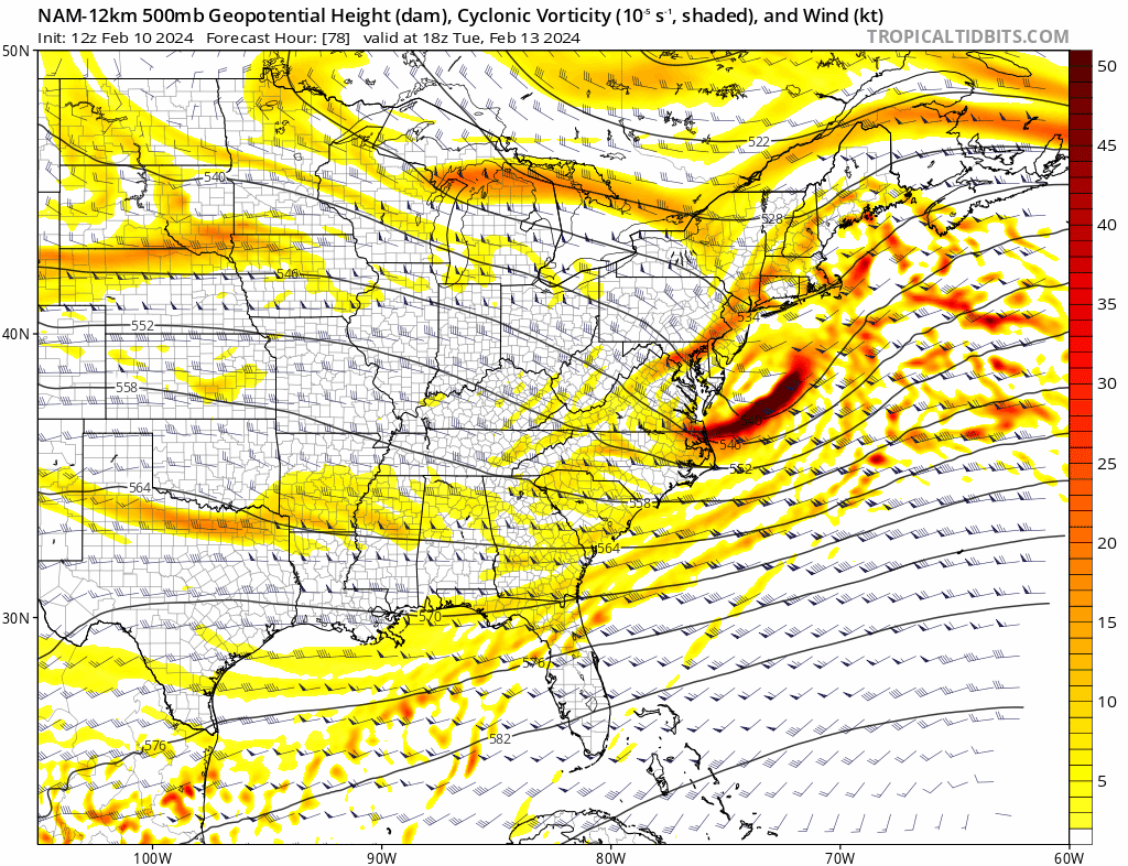
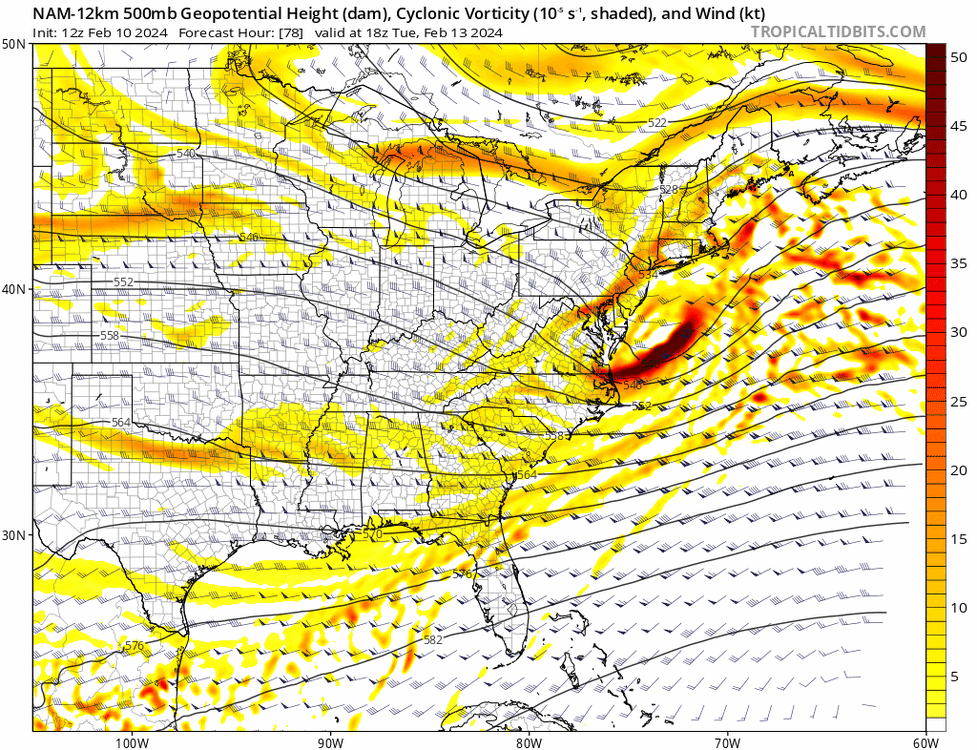
Following a Miller A/B hybrid type coastal potential, Feb 13th ... As yet untapped potential and a higher ceiling with this one
in New England
Posted
Well.... It isn't a thing until it is a thing! So if we don't get much, we never had anything yet..... ( Did you get that? ) Lol
Seriously... Super disappointed but life goes on.