

Snowcrazed71
-
Posts
1,837 -
Joined
-
Last visited
Content Type
Profiles
Blogs
Forums
American Weather
Media Demo
Store
Gallery
Posts posted by Snowcrazed71
-
-
I'm guessing they're just taking the NAM and paying it no mind.
After the winter storm watches that are hoisted for Southern New England, they have the winter storm watch going from Saturday evening all the way through late Sunday night. Night. So I guess they expect the snow to continue through the day Sunday and to Sunday night.
-
I haven't seen anybody say anything about this, but they NAM tends to be over amped especially 3 days out. We've seen this before with other storms where the name brings things up and over amps things. And then we see it settle back down within a day or so. I know this would be good for some in central/northern New England if this were to verify, but, I just don't see this going that far north.
-
 2
2
-
-
Something's definitely off with this run. It seems like a rain snow line. Just collapses by Sunday afternoon and continue through Sunday evening. Oddly, the GFS in Euro aren't showing it going that late. I don't believe. There has been talking about the storm going into the afternoon evening. There's also been talking with ending by the early afternoon. Still not sure on that
-
5 minutes ago, WinterWolf said:
I wasn’t meaning that…he got my point. And absolutely no snow goggles on here bra.
Totally with you. People freak out when models trying to different way in one run. Just as some people grasp on to miles that may show crazy amount of snow. Point is, I mentioned this couple days ago. The windshield wiper effect. Bernie reyno always talks about that and It couldn't be any truer. Just go right in the middle and we're going to do just fine in southern New England.
-
1
-
-
17 minutes ago, MJO812 said:
Wow
15 minutes ago, CoastalWx said:Models gone wild. All over the place. What a Kraft ending here on gfs.
Can anyone post the latest GFS?
-
9 minutes ago, Torch Tiger said:
Good trend! Hopefully the rain/ mix line surges to the pike!!
Dork. Lol
-
1
-
 2
2
-
-
5 minutes ago, Sey-Mour Snow said:
GEFS still paltry most members have 2" or less for all of SNE
Well with all the models trending better than they did last night except the euro, it's a good sign.
-
6 minutes ago, WinterWolf said:
That’s because it only goes out to 84 hrs…so it’s just coming into range now.
Yeah... It's been so long that I forgot .lol
-
2
-
-
4 minutes ago, ineedsnow said:
not that it means much but big changes on the NAM
In what way? It's funny. I was just thinking about the NAM that we haven't talked about it or brought it into any of the conversations with any storms as of late.
-
28 minutes ago, TauntonBlizzard2013 said:
Euro tossed. On the extreme side of its own ensemble suite
So are you saying you're going more with the GFS side?
-
2 minutes ago, UnitedWx said:
Much warmer this A.M. 26 degrees. Mr. Cox on TIC... after two minutes of hedging says early estimate for CT is 3 to 8 inches. Seems to be quoting the EPS at this point
You're exactly right. He actually just had the euro map up from last night. Although he did say there's some model differences, he seems to favor the euro. I also watched Gil Simmons from WTNH with a video on social medi that he just put out 25 minutes ago. He also is favoring the euro as well. Mentioning that there is a wide range of snow totals but he thinks this is looking like a plowable event.
-
2
-
-
It's fun to watch some of the comments. We won't have a final solution until Thursday, Friday time frame. We're going to get that windshield wiper effect for the next few days. I wouldn't be surprised if it ticks up again and back the other way a few times.
-
23 minutes ago, qg_omega said:
She gone, Pope FTW. He was the only one showing 1/4 going the way of 1/7
And you wonder why people have issues with you. You play games.
-
 1
1
-
-
2 minutes ago, WinterWolf said:
Pickles…I was waiting for this to happen. It happens with every single system. We were due for some bad runs. Think what you want. That’s my call. We’ll go through a few of these, then it will improve some come Thursday some time. That’s my call. 18z always goofy.
I was thinking the same thing. I mean aren't the 18Z and 6z The two model runs that tend to be wonky and that we always say pay no attention to? It's also only Tuesday. So people are taking the 18z like we're in trouble, it's definitely a hoot.
-
1 hour ago, Layman said:
I have to admit myself, almost spit out my gum at my desk at work when I saw this. Thanks for the laugh. It's a good one
-
1
-
-
1 hour ago, ORH_wxman said:
What a weenie run on 06z GFS. That’s how to run the upcoming pattern.
What's it showing?
-
29 minutes ago, moneypitmike said:
Plenty of time for this to become a colder rain.
I think your right, but looking beyond this I think we are in a good position for more Snow opportunities
-
1
-
-
1 minute ago, 40/70 Benchmark said:
I'll bet the mid levels would deliver near me on that run.
Not sure about that... TT already said that several inches will be a virga storm... ;-)
-
34 minutes ago, Torch Tiger said:
probably 2-3" of heavy virga for many
Really? So, why do you think that? Just curious on your take and reasoning on it being Virga?
-
2
-
-
7 minutes ago, TauntonBlizzard2013 said:
Verbatim this 18z gfs run is horrific for New England. Scraped on the 7th and Rainer for 95% of the forum on the 10th and 12th. Hopefully that’s not how it plays out
Yeah... 18z GFS ( especially for the 1/10-12 threat ).... Not paying any mind at this point.
As far as the more immediate threat for later this upcoming weekend.... The GFS actually came north a good bit from its earlier run today. With the other models showing hits... I think the direction is good for 1/7.
-
If we had to take today's run as the final outcome, I would be perfectly happy with that. Even though Connecticut wouldn't be in the biggest snow amounts, 8 to 10 inches is nothing to shake a stick at ( and that's all of Connecticut with some areas with more than 8-10 ). But it gets people to the west and people to the east with even more snow than that.
-
17 minutes ago, ORH_wxman said:
Lot of spread on GEFS.
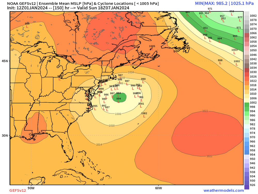
Well there are definitely more members to the west of the OP than there are to the right. Not sure if that's good or bad. But there are many that are just off the coast.
Seems like there are nine that are far enough east that we won't give us much of anything. Been there about 11ish in the middle which seem to be a good track for Southern New England. Then there's about nine huggers. Depends on where some of them go. I will say that about six of them are in a spot where if they slide east northeast they'd be a good track for selling New England as well.
To me, this is definitely something good to track.
-
1
-
-
12 minutes ago, Torch Tiger said:
why? 7th is obviously a whiff
Ha!! Said who? You? Lololol
-
It's so early yet for any kind of call for next Sunday, Monday. Yesterday was a beauty of model runs. The nice part is it got a lot of us in a different place from where we had been. There's no way to know what's going to happen for the storm on the 7th for sure. Even though today's runs have been mediocre at best, there's going to be changes with the model runs later today, tomorrow, Wednesday and Thursday. Same goes for the system on the 10th. We have no idea if it's going to rain, snow, nothing, cutter, coastal. Just focusing on the storm for Sunday for now. I'm just glad that we're tracking a winter type storm now, not a complete rain job!
-
1
-

Monitoring first regional significant winter impact event. Magnitude likely tempered. At this time NE PA/SE NY and SNE primarily. Jan 7/8.
in New England
Posted
Reggie Jackson for the win!!!!