

Snowcrazed71
-
Posts
1,837 -
Joined
-
Last visited
Content Type
Profiles
Blogs
Forums
American Weather
Media Demo
Store
Gallery
Posts posted by Snowcrazed71
-
-
2 minutes ago, ineedsnow said:
check out the 1z HRRR

What's it show?
-
 1
1
-
-
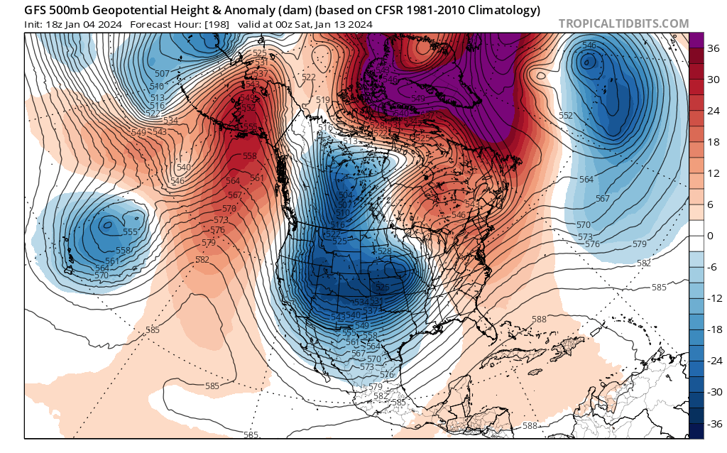
Am I not mistaken that in the past, some of you have said that the euro is not at its best when it's within 12 hours of the start of a storm? Point is if the euro looks shitty at this moment, do we really follow it. GFS looked good for us here in Connecticut, the Rgem was a nice hot. I think wobbles at this point just as they are common noise
-
Just now, WeatherX said:
Do you believe him?
Nah, he's your one of the mill meteorologist... JOKING!!! Ryan's not want to hype things up unless he sees everything lining up close to the event. I've always followed him and he is one is definitely one of the good ones.
-
4 minutes ago, WinterWolf said:
Ryan H just said it could be snowing at 2”/hr at this time tomorrow night in CT…so that would make sense.
Yeah.... Yeah he's coming back on in about 2 minutes to discuss everything.
-
-
5 minutes ago, NW_of_GYX said:
gives the berks some front end snow but that's about it. Others have said that this is still worth watching for SNE but I would hedge against that. This one's for NNE IMO, and it may be for far NNE. time will tell
I think there might be one for two or three days after that that could be a biggie for everyone... But we have time for that
-
21 minutes ago, NW_of_GYX said:
GFS coming in colder for the 13th, looks more like euro. Whites crushed on the front end
What does it look like for the rest of the area? Is it just the northern New England deal or is it look like it could be something for Southern New England as well?
-
Jeez.... Keeping track of each model and who is getting what is like being in a blender...lol
-
1 minute ago, Damage In Tolland said:
New HRRR quite a bit colder and south .That earlier run was abysmal
Is the HRRR a good model though? What's it look like Kev?
-
9 minutes ago, NW_of_GYX said:
I like the 13th period. GEFS mean cuts to the lakes but it's been very consistent on the OP runs except for a few runs yesterday. Transfers the low to the benchmark, cold air in Canada, I like that period for a region wide event.
We pray
-
32 minutes ago, dryslot said:
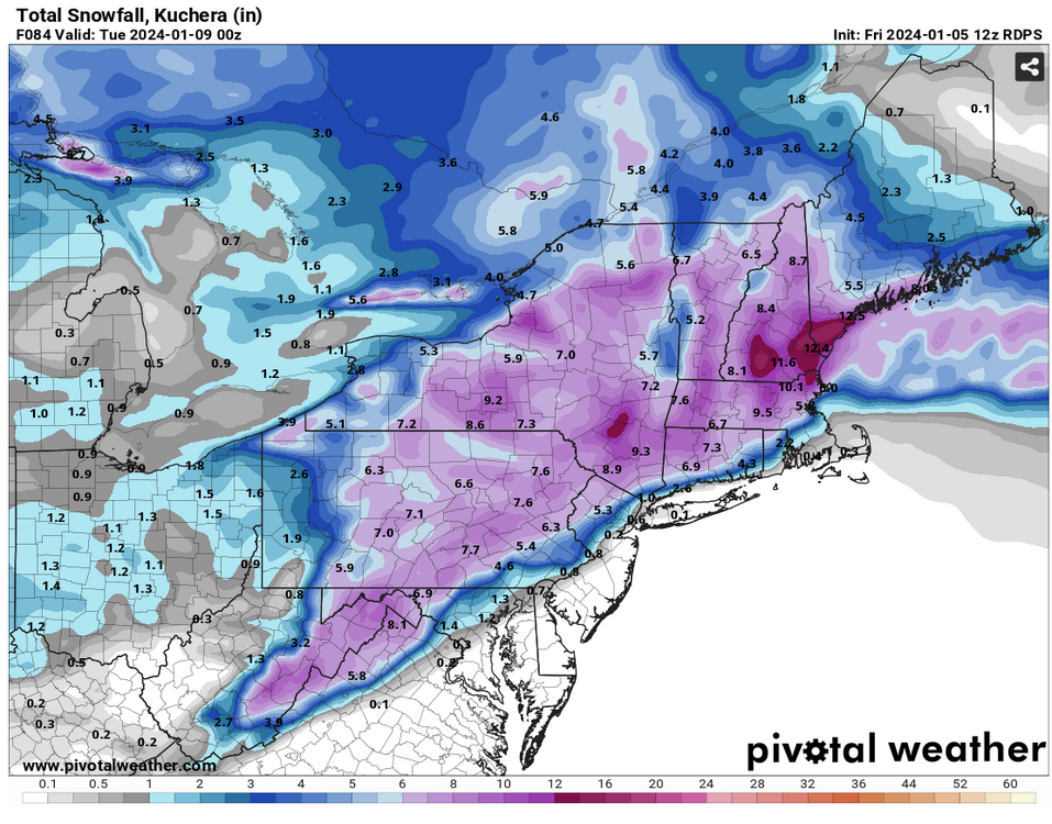
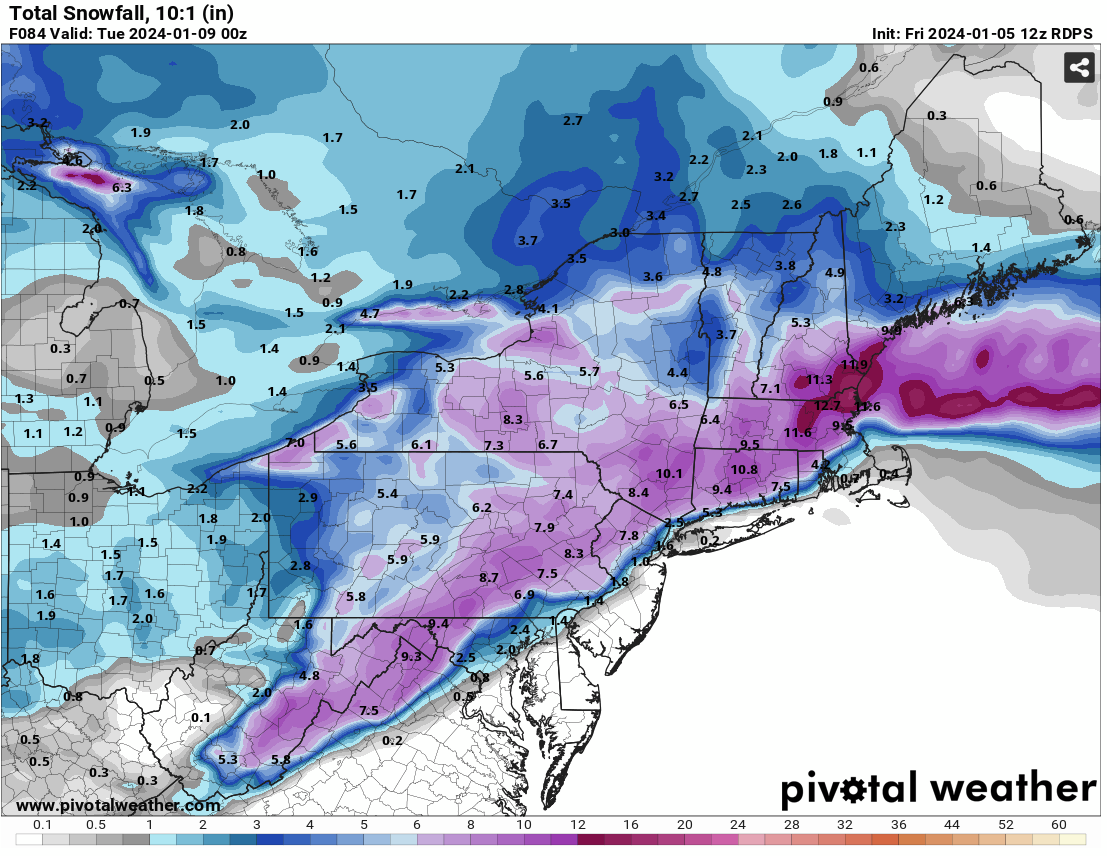
That 12z Euro run produced some 40" burgers on the kuchie maps......lol
I'm assuming this is for next weekend's possible storm? Any maps to post?
-
2 minutes ago, RUNNAWAYICEBERG said:
My wisdom grows reading his posts.
My exact words when I saw that map was " No Sh&t Sherlock " lol
-
3 minutes ago, MuddyWx said:
solid with the kraftian finish
.thumb.png.4ffe463d9238675f8dac39e77ff25777.png)
Still a solid look for us in CT. I was a little concerned, but in general we've been in that range of five to 10 in on average for the last several days. If we got more that's just a bonus. But I'm happy with 5 to 10
-
8 minutes ago, UnitedWx said:
Funny, SOO glad to be out of (living) in CT. I just NEVER understood the appeal of West Hartford... you couldn't pay me to live there!
I don't live in West Hartford, I work in West Hartford. Love where we are in Plainville. I'm up on rattlesnake mountain so I'm a little higher up than the area around me. Super quiet where we are, lots of wildlife, the schools are great here for my daughter.
West hartford's a very dynamic mix of people. You definitely get the yuppies who thinks they're shit? Don't stink, but you do get a good mix of other people as well ( at least the clients I have in my showroom ).
We have good friends in Simsbury which is a great town.
-
1
-
-
4 minutes ago, RUNNAWAYICEBERG said:

And how's this one for reliability? Just not sure myself.
-
3 minutes ago, JKEisMan said:

This makes me feel good. What are your thoughts guys. This is more reliable source than the NAM?
-
2 minutes ago, weatherwiz said:
I miss West Hartford...certainly got screwed at times, but was pretty fortunate to have three 2' snow events. I hate it here in Springfield. I so can't wait to move back into CT.
Funny. I used to live up in East longmeadow and then somers. Back in Plainville and How much happier back this way. Work in West Hartford and really love the area
-
1
-
-
I'm hoping the 12Z runs settle it back down a bit from the NAM ( My gut is will come down a little from what the name showed and not be has North ).
If it does go more north, then we wait a little longer. That's all we have lol. It has been fun tracking the so far... I think it will still see a good four to eight inches in Connecticut
-
10 minutes ago, STILL N OF PIKE said:
Time for a pope rising from ashes meme
thou I think he said suppressed and Mild
Lol... He did have it suppressed to the south.
One thing about the NAM ... I've seen several times a day or two before a storm where it had it too far north and would correct itself as a storm was going. I'm not sure I buy this super North trend on this model. I still think it's trended north but not this far. We shall see
-
31 minutes ago, 40/70 Benchmark said:
This is why NWS remains conservative until the last possible moment....there are subtle ebbs and flows in guidance that have relatively large impacts on sensible results and are not worth compromising consistency until very late in the game.
I agree, and I have a sneaky suspicion that the 12Z runs will bump it back down again. I truly don't think that late last night and this mornings runs are the final outcome. They have been fluctuating back and forth like this for the last few days. Now. I'm pretty confident that most of Connecticut is in the four to eight range, but I do feel there's a possibility can bump back up to 6 to 12. The models are still trying to figure out exactly where the second piece of energy catches up to the first. I'm pretty happy even with 4" to 8" as we've haven't seen this in quite some time.
I know most of it's going to wash away from Tuesday to Wednesday storm. But I do think we have some good stuff coming up later in the month. And who knows what February will bring at this point.
-
2
-
-
14 minutes ago, MJO812 said:
Mid January looks good on the models
Good, hopefully it brings you some sweet winter weather as well. How did you waited longer than most of us on here lol
-
1
-
-
16 minutes ago, qg_omega said:
It was easier to handle when the whole country was warm. Now we bask while the west has historic cold and snow as the SE ridge and NAO connect, 2024 meet 2023.
Okay, maybe for the short term, but that cold has to go somewhere. It will be heading east. Then again, I know who I'm talking to....
-
2
-
-
16 minutes ago, Torch Tiger said:
Look at NNE, that's no good....also some of that qpf added there is not associated with the storm so it's worse than it looks
TT .... But this never really was a storm for northern New England from the beginning. Only in the last several days did it show some model runs where it pushed into southern parts of northern New England. Hopefully you guys will get into some of this ( although, you're not even in northern New England lol )
-
1
-
-
4 minutes ago, Torch Tiger said:
gfs was rubbish for much of the region.
Rubbish??? What are you looking at?
-
 1
1
-
.png.759ad1ad27bd8ce28ae6b03b455619ff.png)

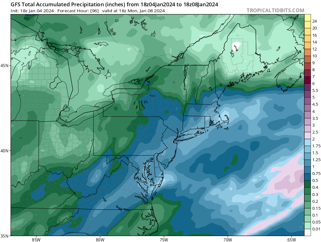
January 6-7, 2024 Winter Storm Obs Thread
in New England
Posted
??