

Snowcrazed71
-
Posts
3,216 -
Joined
-
Last visited
Content Type
Profiles
Blogs
Forums
American Weather
Media Demo
Store
Gallery
Everything posted by Snowcrazed71
-
I've said my peace.
-
Okay. Well make sure you're backing up your words then as facts. Just saying.
-
I've said this before and I'll say it again. This is the most pessimistic forum I've ever been on. A lot of you guys give up on everything way to soon. Yea..last year ended up like crap and we were very dissapointed, but a lot of you are brutal, and even bullies at times to others. This is a forum to discuss what may be happening, not bittercasting that the future of this Winter is over. I'm very sure I'll have people comment on this post in a negative way, but I could care less. I am still optimistic about the rest of the winter. I will take a good February ( and even March when we have had some of our greatest blizzards ). With 2020 being such a " locked in the house " kind of year, this type of activity on the forum is supposed to be an enjoyable one. For anyone who disagrees, well then I have an entire ass you can kiss...lololol. To all those who are on here to discuss the prospects of something good and who are optimistic, I'm with all of you. Now... It is looking like we have some good possibilities in early January. Its not set in stone, but it is in the realm of possibilities.
-
I get it, but from past experiences... Things are bound to change ( as the models tend to do ). Honestly, I have been on a few blogs, and the mood is more on discussing models and what things may or may not happen. Here... There is so much complaint and statements always being thrown out of cutters and winter is no where to be found. Not really something that is appealing to discuss. Thats all I am saying. But, carry on the doom and gloom.. Winter is over guys..cutters the rest of this winter. Enjoy the mud and rain and warmth. ;-)
-
Geez. So many debbie downers..lol. had to laugh at the one comment about not having any more tropical systems. We're getting one tap has to fall and Christmas. You guys are a bunch of cry babies. The funny thing is all you guys are going to be screaming with joy once we start seeing some good Snow events again, which we will.
-
Maps?
-
So.. I've accepted the fact that X-mas will be wet ( possibly some white on x-mas day ). But.. Things still look good going forward.
-
If you remember.. When in our snowiest winter of 95-96, we had a big thaw and heavy rains ( I think in Feb ) but went back to snow after that. I'm not sure there has been any winter where every single storm is a coastal or a clipper. It sucks we're having rain Christmas Eve/ day..but..there still a bit of tweaking to be done regarding that storm. However.. Talk of doom and gloom because of this storm heading into the new year...lolololololol. That is funny. Well be fine. Haven't even hit January yet. Relax poeple.
-
Go away.
-
Just took a measurement. Have 11-12" now. Looks like we have several more hours to go. We should pick up another 3-5 more inches. Forecasted very well. Should end up around 14-16". Would have loved that deform band, but I am more than happy with where we are.
-
Active mid December with multiple event potential
Snowcrazed71 replied to Typhoon Tip's topic in New England
That is very nice. Now do we think are ratios will be higher than 10:00 to 1? Seems like we're going to be very cold here in Northern Connecticut -
Active mid December with multiple event potential
Snowcrazed71 replied to Typhoon Tip's topic in New England
-
Active mid December with multiple event potential
Snowcrazed71 replied to Typhoon Tip's topic in New England
Anyone have the latest model run to post? -
Active mid December with multiple event potential
Snowcrazed71 replied to Typhoon Tip's topic in New England
Co8n man. You're better than that. You know it's not going to snow until dark tomorrow. I believe every model had the snow or if here but early afternoon the latest ( and that is far eastern ct ). -
Active mid December with multiple event potential
Snowcrazed71 replied to Typhoon Tip's topic in New England
What's up neighbor. It will be interesting to see what we get from this storm. I'm right on the a farmington/plainville line. Work in west Hartford. Let's see if the Beijing sets up and we see any differences from WH to my hometown -
Active mid December with multiple event potential
Snowcrazed71 replied to Typhoon Tip's topic in New England
Why bother having the kuchi maps then? Do they ever come to fruition? -
Doesn'tnt seem to be there anymore? Of anything.. There may be more of a coastal trying to get closer
-
Active mid December with multiple event potential
Snowcrazed71 replied to Typhoon Tip's topic in New England
Yeah. I noticed channel 3 WFSB is calling for mostly 10"-20", Gil on Channel 8 WTNH is calling for 12"-24" and also very windy with Blizzard conditions. -
Active mid December with multiple event potential
Snowcrazed71 replied to Typhoon Tip's topic in New England
Funny.. NBC wvit Bob Maxon still has thr state at 6-12" but, he sis say he thongs most will see a foot. He also said a few towns may see more. He is blending both the Euro amd the GFS amd blames the totals for not being higher on the storm racing right out to sea. He said if it were to slow down.. We would see 2' + -
Active mid December with multiple event potential
Snowcrazed71 replied to Typhoon Tip's topic in New England
Do you guys think this really does any more changing? Im.starting to see both come together. Not looking like SNE will be getting into the double digits. At least not the recent trends. I want to beleive in the Nam... But just not sure what to think. -
Active mid December with multiple event potential
Snowcrazed71 replied to Typhoon Tip's topic in New England
Lolol. Come on man, you know I want the big totals LOL. However, my True question is the legitimacy of the NAM model at this point. I know people say not to use a man model as a long-range model, but wouldn't 48 Hours not be long range. Are we getting into it will house now? -
Active mid December with multiple event potential
Snowcrazed71 replied to Typhoon Tip's topic in New England
Are we at a better time frame now being within 48 hours of the storm and using the NAM model. I'm still worried about the gyro heading stupid South, and the GFS not really moving North but, now that first thing is on shore is much better sampling going on for tonight tomorrow. I'm just going to expect 6in and if I get more that'll be exciting. I'm thinking I'm in a very good spot being right in the center of Connecticut -
Active mid December with multiple event potential
Snowcrazed71 replied to Typhoon Tip's topic in New England
So is the EPS better than the Op generally? -
Active mid December with multiple event potential
Snowcrazed71 replied to Typhoon Tip's topic in New England
Well.. The 18z Euro kuchera looks good with the snowfall for SNE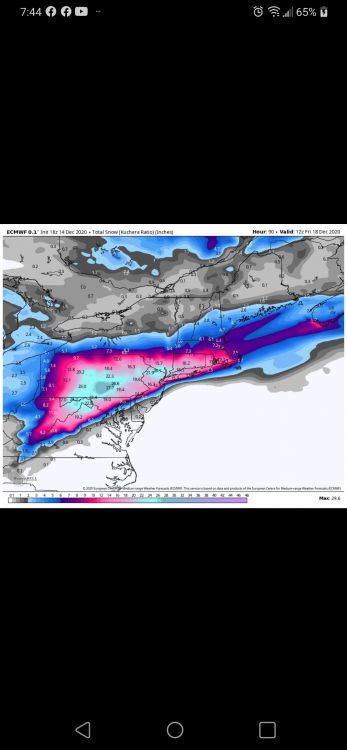
-
Active mid December with multiple event potential
Snowcrazed71 replied to Typhoon Tip's topic in New England
Tracking is so exhausting LOL I fully admit that I am a weather weenie at 49 years old. I've Loved tracking the weather my entire life. Even had a stint in college for meteorology, ending up in Design ( which I love ). With that said, even if we see 6 to 12 in I'll be super happy. Plus, we still have January February March and even April.. At least it's not the last few years for here in Southern New England


