EarlGrey
-
Posts
172 -
Joined
-
Last visited
Content Type
Profiles
Blogs
Forums
American Weather
Media Demo
Store
Gallery
Everything posted by EarlGrey
-
I bow my head in prayer. Oh great frosty overlords, bless us with your icy confetti. I promise to shovel with a smile. Just one snow day, please!
-
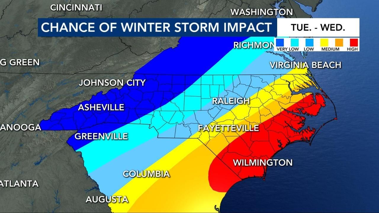
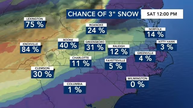
From WRAL Notice the transition gradient, except this time it’s flipped!!

-
Will I be working from home on Wednesday?
-
Was actually thinking of going to the mountains next weekend and now you up in here saying I should go to the beach?!
-
Lock it in.
-
Just when I think I'm out they drag me back in. Snow! Snow! ackkkkkkkkkk
-
1/10-11 super awesome winter SE OBS thread
EarlGrey replied to strongwxnc's topic in Southeastern States
That was a let down for sure in Central NC and Triangle area. On to the next storm but I’m hoping the bad juju has been broken and we can get something else. -
1/10-11 super awesome winter SE OBS thread
EarlGrey replied to strongwxnc's topic in Southeastern States
It’s a bust in Wake County. Just ice and sleet. -
1/10-11 super awesome winter SE OBS thread
EarlGrey replied to strongwxnc's topic in Southeastern States
Humidity up to 74% and temp down to 30.2F! -
1/10-11 super awesome winter SE OBS thread
EarlGrey replied to strongwxnc's topic in Southeastern States
It’s now 35 where I’m at -
1/10-11 super awesome winter SE OBS thread
EarlGrey replied to strongwxnc's topic in Southeastern States
Man don’t get our hopes up like that. -
The humidity has been steadily decreasing in Wake County. Is that a good or bad sign?
-
Is there a correlation with snowing in GA to how much it can snow in NC?
-
What radar sites is best for snow tracking? NWS?
-
Dat gradient tho, lawd. Still I’ll take it.
-
That’s almost perfect.
-
From WRAL.
-
I’m scared it will be though.
-
Just got some sleet. I’m happy, it means frozen things CAN fall from the sky.
-
That would be a good weekend to go skiing at Winterplace or Wintergreen.
-
I would be happy with that too. At least it would be something to look at!!!
-

-
I haven’t cried this much since I got stood up at prom.

-
If we could lock that in right now I would take that and be happy with it.
-
No not at all, sorry if you thought so.