
jaydreb
-
Posts
2,043 -
Joined
-
Last visited
Content Type
Profiles
Blogs
Forums
American Weather
Media Demo
Store
Gallery
Posts posted by jaydreb
-
-
Incoming on GFS. Looks like we’ll have another 100+ page thread next week.
-
 2
2
-
-
Almost time for Euro.

-
Let’s just agree not to look at the 3k.
-
 1
1
-
-
1 minute ago, NorthArlington101 said:

At least we get to enjoy frigid windchills.
-
-
5 minutes ago, Ephesians2 said:

Pretty significant cave to the GFS. Euro had been showing 20+“ totals in NJ and Delmarva.
-
 2
2
-
-
8 minutes ago, WxUSAF said:
It’s kinda hilarious that our region seems to have relatively narrow goal posts on snow potential whereas areas both north and south of us have just enormous variance. NAM and GFS give eastern NC and southeast VA a MECS and Euro gives them a dusting.
Euro gives NNJ two feet while GFS gives it a few inches. Crazy difference.
-
Just now, KAOS said:
Where did the snow bus go? Is there no longer a bus? Was it retired? I miss the bus.

-
3
-
 1
1
-
-
1 minute ago, NorthArlington101 said:


Are those darker purples moving northward towards us? Or moving east?
-
-
1 minute ago, MillvilleWx said:
Look north for the fun
")

Do you mind explaining what exactly we are looking for here? Thx.
-
 3
3
-
-
8 minutes ago, Ji said:
tads and slights--we need better than that
3 tads = 1 jump? So we’re just a few tads away from a jump in QPF.
-
1
-
-
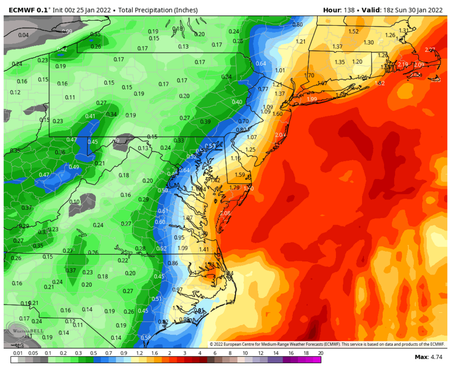
10:1 still gives DC metro 5-6” which is nothing to scoff at.
-
7
-
-
It’s actually a tick west with the heavies from the 0z run.

0z

-
9 minutes ago, leesburg 04 said:
Every shift nails the same locations while the fringe areas stay relatively consistent. I'm no expert but I do have to pay attention to trends and details in my work and what I notice is despite all of the shifts and changes at any hour the end results aren't changing drastically so to me that says we probably have seen something close to the final solution save a few tweaks. Again, hope i'm wrong but if my area gets 2-4" that will cover everything and look gorgeous and I can be happy with that.
True. GFS has “trended west” the last few runs, but it’s still way east of where it was yesterday at this time. This was yesterday’s 12z run.

-
2
-
2
-
-
1 minute ago, leesburg 04 said:
I mean i get it all of these models are close enough that it makes sense to keep on tracking but it sure feels like the top end has shown it's hand on many of these model runs even with the shifts. Of course i am probably wrong but that coastal isn't going to hit us beyond the eastern shore. I'll keep following though but it's much easier being out my way to just let it go. Hope i'm wrong
A lot of us were probably ready to move on last night, but then the 0z Euro sucked us back in for another round of this insanity.
-
1
-
-
1 minute ago, osfan24 said:
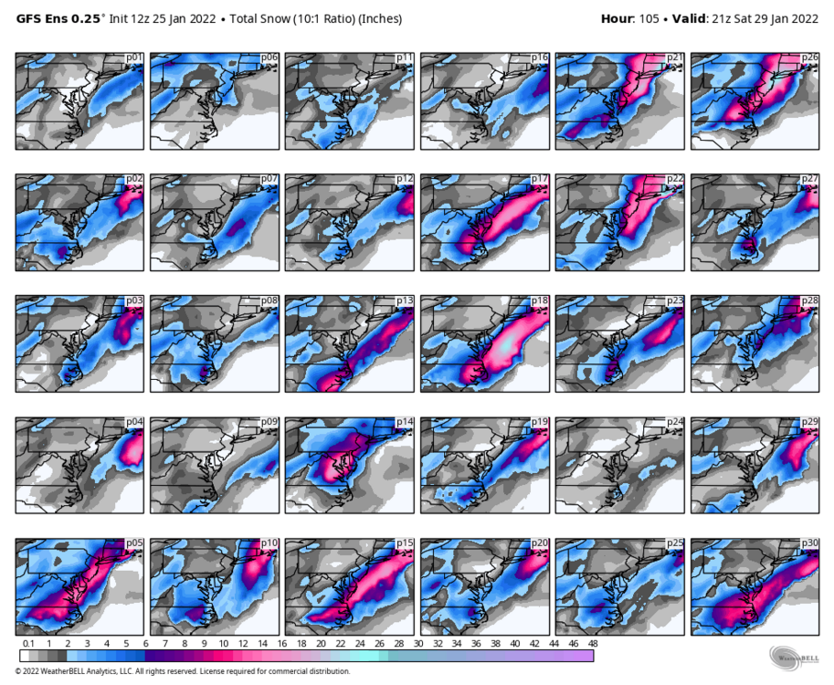
Now that's the trend we need. Nice clustering of lows not only moving west but also shifting south as well. I would expect the some pretty big snows very close to 95 with those low positions with the individual GEFS members. The question is if the GEFS have any value anymore.
-
1
-
-
1 minute ago, DDweatherman said:
I'm more focused on this

I’m not seeing much change vs 6z. Seems like it just reduced the spread somewhat but kept the general mean the same. Maybe a subtle shift west but not much IMO.
-
 1
1
-
-
GEFS precip panels look pretty similar to 6z. Looks a little better at h5. Not a step back but not a huge shift IMO.
-
I tuned in to the Euro to see the final nail in the coffin, but now I’m invested for another day.
-
1
-
1
-
-
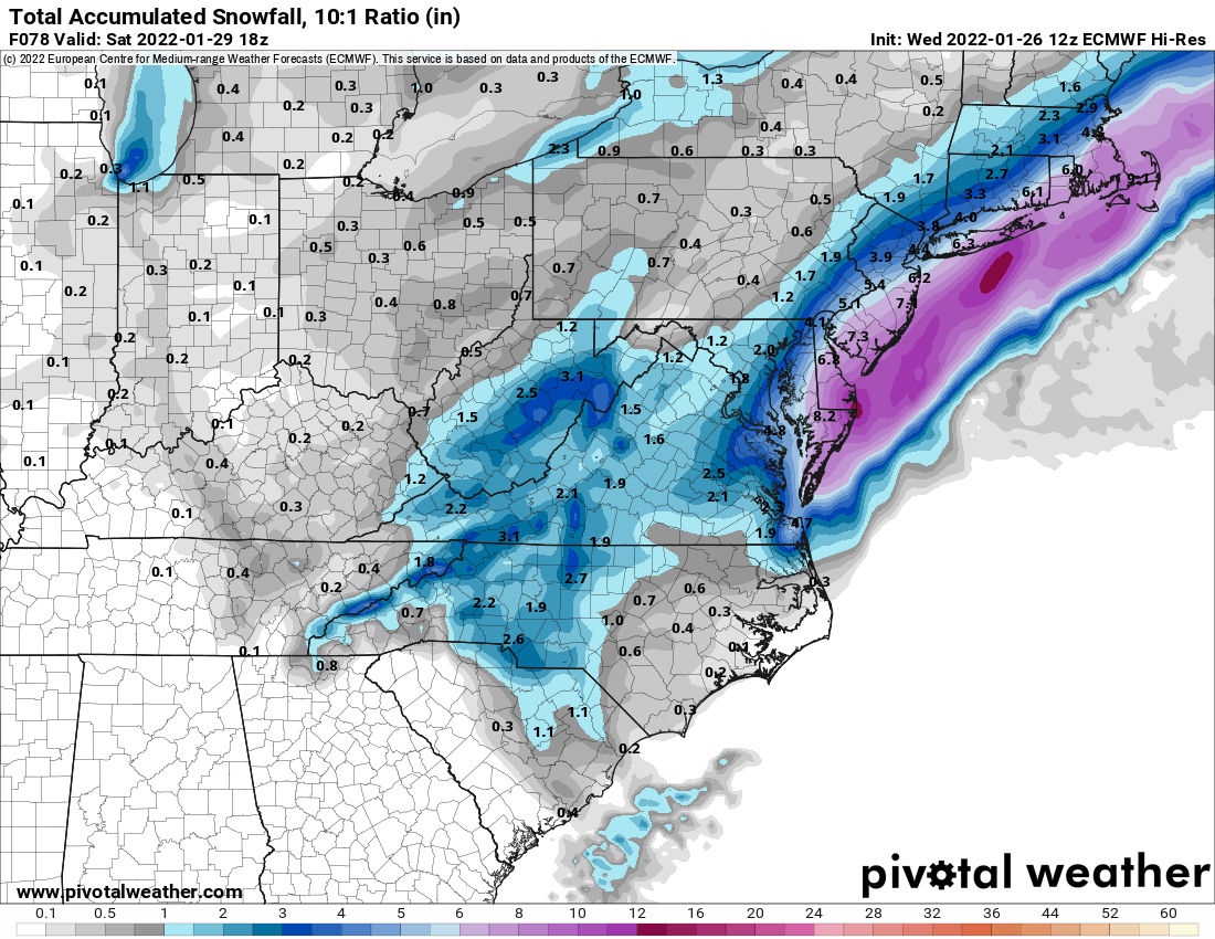
Even Short Pump gets almost 6”.
-
1
-
-
Euro is either playing catch-up or leading the charge.
-
-
Just now, Maestrobjwa said:
Yeah that would hurt a bit
If we somehow get 6” out of this storm that would be a win, no matter what NYC gets.
-
5
-


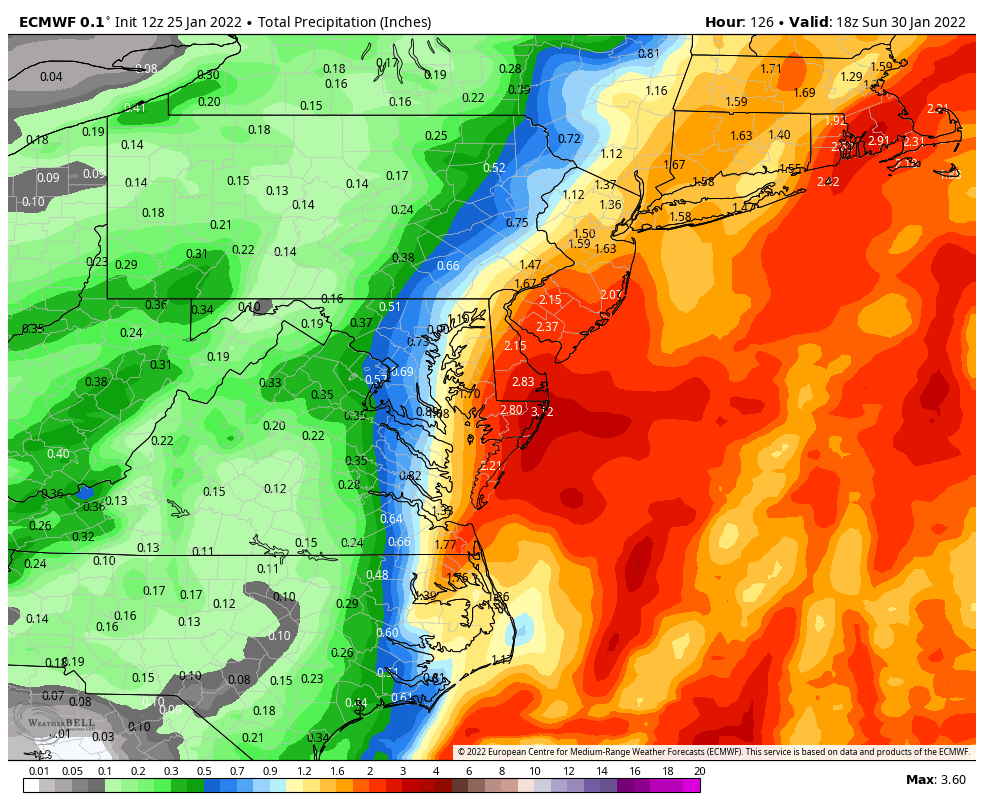
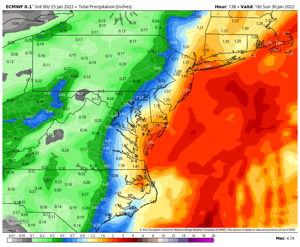

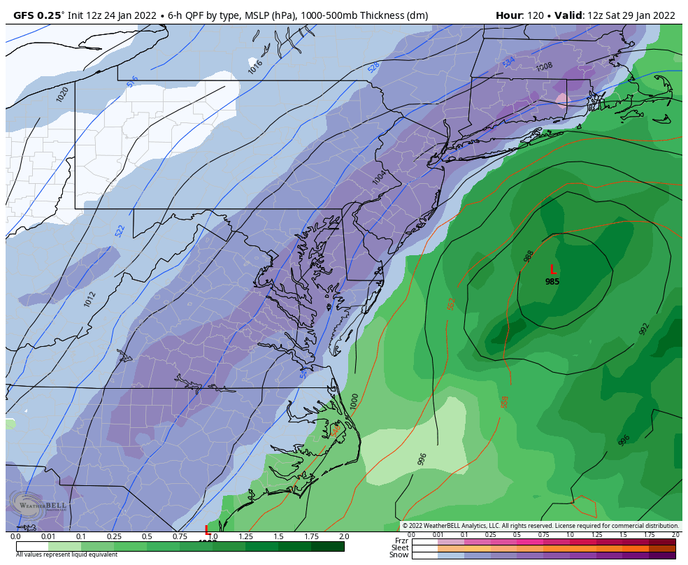


January 28-29, 2022 Miller abcdefu Storm Threat
in Mid Atlantic
Posted
Signs of an impending fail:
”Convective feedback”
”Angle of the vorts”
”Predecessor rain event (PRE)”
The RGEM is the best looking model