jaydreb
-
Posts
2,116 -
Joined
-
Last visited
Content Type
Profiles
Blogs
Forums
American Weather
Media Demo
Store
Gallery
Everything posted by jaydreb
-
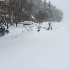
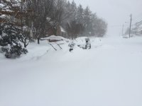
Snowing in N. Arlington.
-
Nice. I’ll take that verbatim and won’t even care about Wave 2.
-
Is that snow for DC or the mix crap that the NAM put out?
-
See my post though. Euro and GFS have totally different precip jackpots. Almost 1” QPF difference in some spots.
-
Yes and no. Look at the difference in precip for VA between the 18z GFS and 18z Euro.
-
I don’t know what to think anymore. Guidance is all over the place and we’re like 24 hours from onset. I think just stop looking at models and just let the chips fall.
-
Round 1 too north? Round 2 too south?
-
Euro only caves to the NAM when it’s bad for us.
-
It’ll be there for Wave 2, when we watch the good stuff slide by to the south.
-
Yeah, I get it. We want the Euro to be the most juiced, not the least. And of course we have to worry about trends.
-
Ok fair point. Blend these then. EDIT: Amazing how far apart GFS and Euro are with respect to precip in central VA.
-
Sounds like too much doom and gloom. Blend these 3 models and most of us are happy, right?
-
Maybe I’m wrong, but I don’t think that a run to run change of like .15” of QPF is a major difference. EDIT: I guess if you multiply it over 3 runs then it’s an issue.
-
Huh. Seems like most other guidance has Wave 2 as the stronger one.
-
Lol, we’re going to be too south for Wave 1 and too north for Wave 2.
-
The second wave seems to be the main show. Let’s hope that hits most of us squarely.
-
The first wave. Lol this map is all over the place.
-
-
-
Such a narrow band of snow. Sheesh.
-
This is what it looked like at the end. Maybe another inch or two.
-
18z vs 12z
-
It’s almost identical to the 12z run, just slightly less precip.
-
Still snowing a little when the run ended.
-
Looks like we do on Thursday evening. Looks sweet.