
jaydreb
-
Posts
2,045 -
Joined
-
Last visited
Content Type
Profiles
Blogs
Forums
American Weather
Media Demo
Store
Gallery
Posts posted by jaydreb
-
-
4 minutes ago, Eskimo Joe said:
LWX must have a different definition of “worst-case” scenario than the rest of us.
-
 1
1
-
 9
9
-
 1
1
-
-
1 minute ago, CAPE said:
Looks reasonable to me considering the antecedent conditions and the progressive nature of the pattern. You really buy those pretty WB clown maps?
It also seems pretty spot on to LWX’s WSW of 3-5” for me.
-
Mid-Atlantic weenies trying to land this one today.

-
2
-
8
-
2
-
-
5 minutes ago, Ravens94 said:

What is FV3? The NAM’s replacement?
-
HRRR is a beauty for many of us.

-
 2
2
-
 1
1
-
3
-
-
This place is going to explode.
-

-
1
-
1
-
-
2 minutes ago, nj2va said:
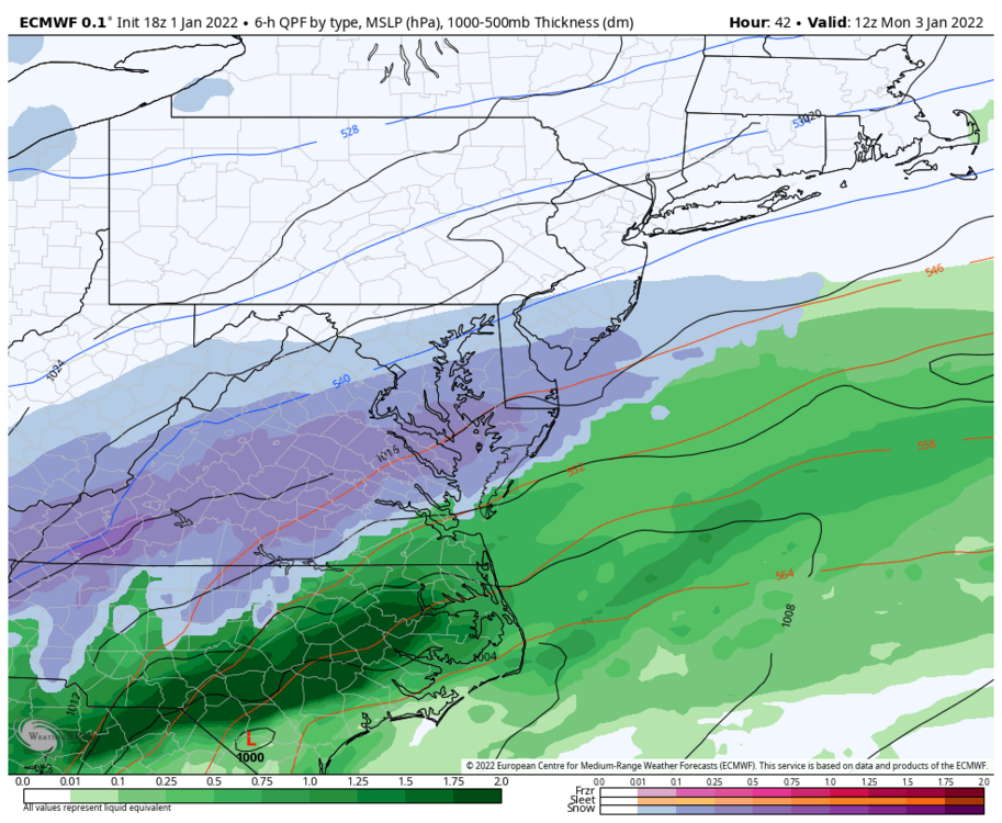
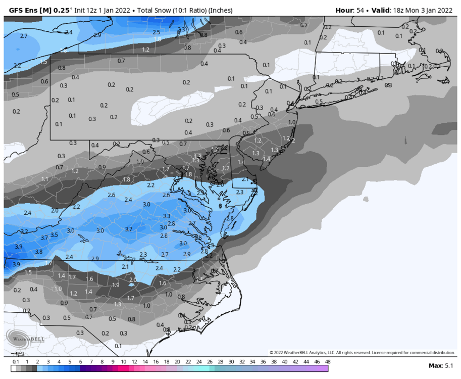
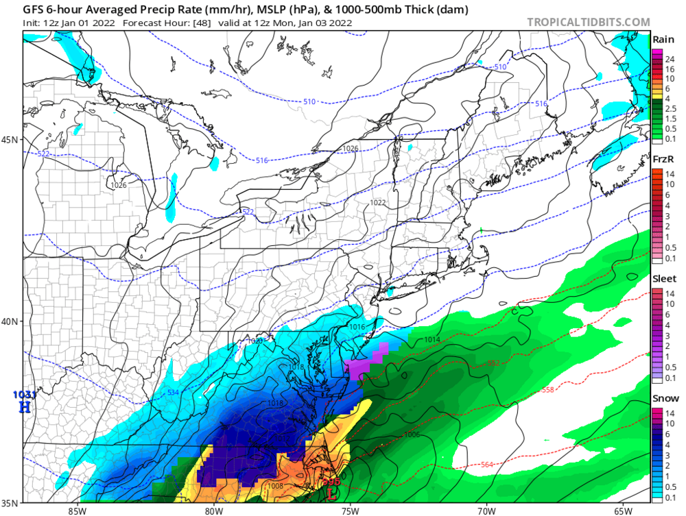
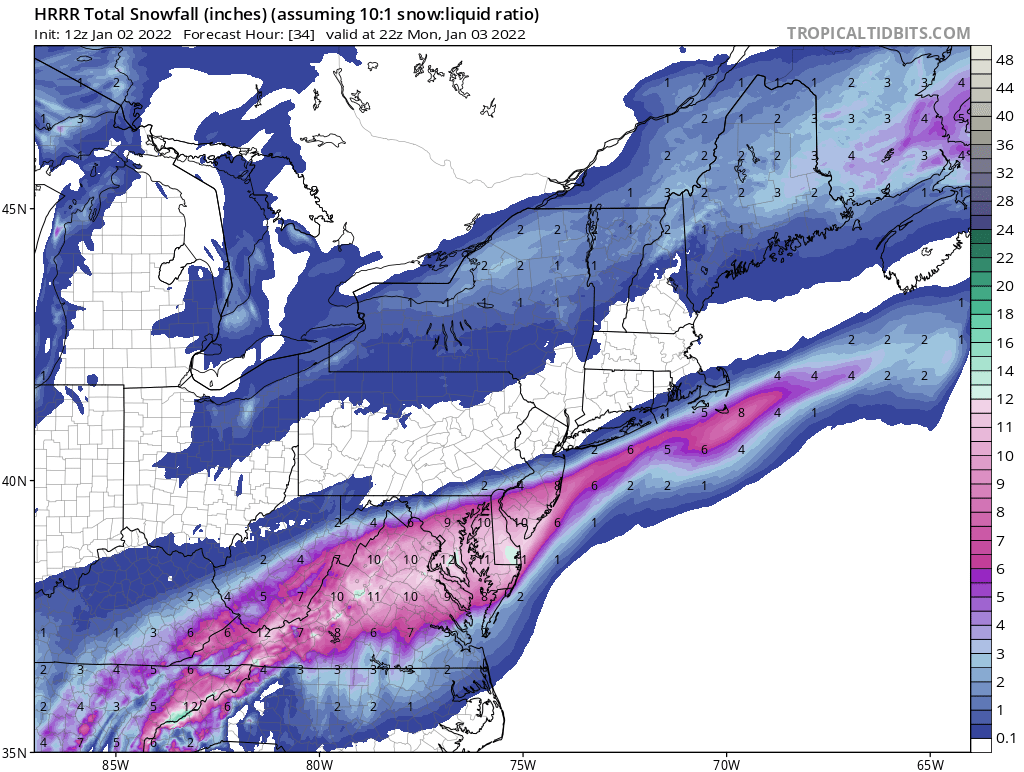
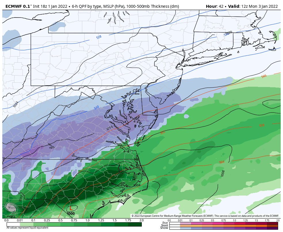
RGEM is a solid hit for the area. Pivotal precip maps shows sleet/mixing into DC (and south of there) but the column (per the sounding) is below freezing. 4” into DC, 1” into Baltimore on the Kuchera map.
Pretty soon we’re going to be sweating the rain/snow line.
-
3
-
1
-
-
Euro takes a nice step towards GFS and RGEM. Just need another small nudge and we are in business.
-
3
-
-
At least Euro won’t be worse than 12z.
-
1
-
-
RGEM is acceptable. We have about 30 more minutes to enjoy this.
-
Just a ridiculous run over run change for GEFS within 48 hours of gametime.

-
3
-
-
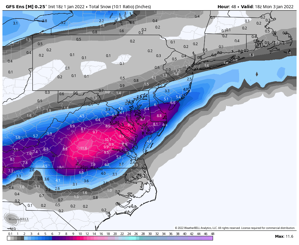
12z EPS looks tasty for Friday.

-
11
-
-
5 minutes ago, stormtracker said:
Yeah, 144 time frame is showing up on all the models. Monday is pretty much dead DC north, so I guess we chase this 144 ghost now
Applicable weenie rules:
Rule 17: Storm after the storm.
Rule 38: The big ones are sniffed out early.
-
1
-
3
-
-
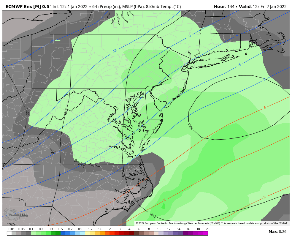
January 7 weekend has my attention. Storm is on every model.
-
2
-
-
Just now, SnowenOutThere said:
GFS also has a late week storm storm on Friday. Heaviest is a bit south but still good for the cities.
Looks just like the ICON FWIW. Models have show this as a period of interest for some time.
-
GFS is oh so close for many of us.
-
2
-
-
Next weekend looking interesting on the ICON as well. It’s always the storm after the storm.
-
Which of you weenies lives here?

https://www.sfgate.com/renotahoe/article/donner-summit-snow-lab-historic-records-16629847.php
-
2
-
-
1 minute ago, Cobalt said:
Pretty decent agreement among the Canadian, GFS, and Euro ensembles for the timeframe into very early Jan. Much like with the fabled D10-15 blocking pattern presented on the models in early Jan of last year, it seems like we'll have to wait a while for those effects to show up in the medium range, only this time we're looking at that pattern shift 2 weeks earlier.
Yep, today’s EPS also transitions into a pretty good looking pattern.

-
12z GEFS starts dumping cold air into the eastern US after the New Year. Stout -NAO all the way through the run.
Pretty amazing anomaly for a 16-day mean.

-
2
-
-
Safe to say that the 12z Euro wants no part of whatever the GFS is smoking.
-
10 minutes ago, Weather Will said:
WB 12Z GFS…. 6 more hours to BELIEVE!!!

Nope. More like 2. Euro comes out at 1.
-
Pretty stout 50/50 and -NAO at the end of EPS run, but need some cooperation from the Pac.


January 3 CAPE Storm
in Mid Atlantic
Posted
GFS looking good thru 18.