ChiTownSnow
-
Posts
814 -
Joined
-
Last visited
Content Type
Profiles
Blogs
Forums
American Weather
Media Demo
Store
Gallery
Everything posted by ChiTownSnow
-
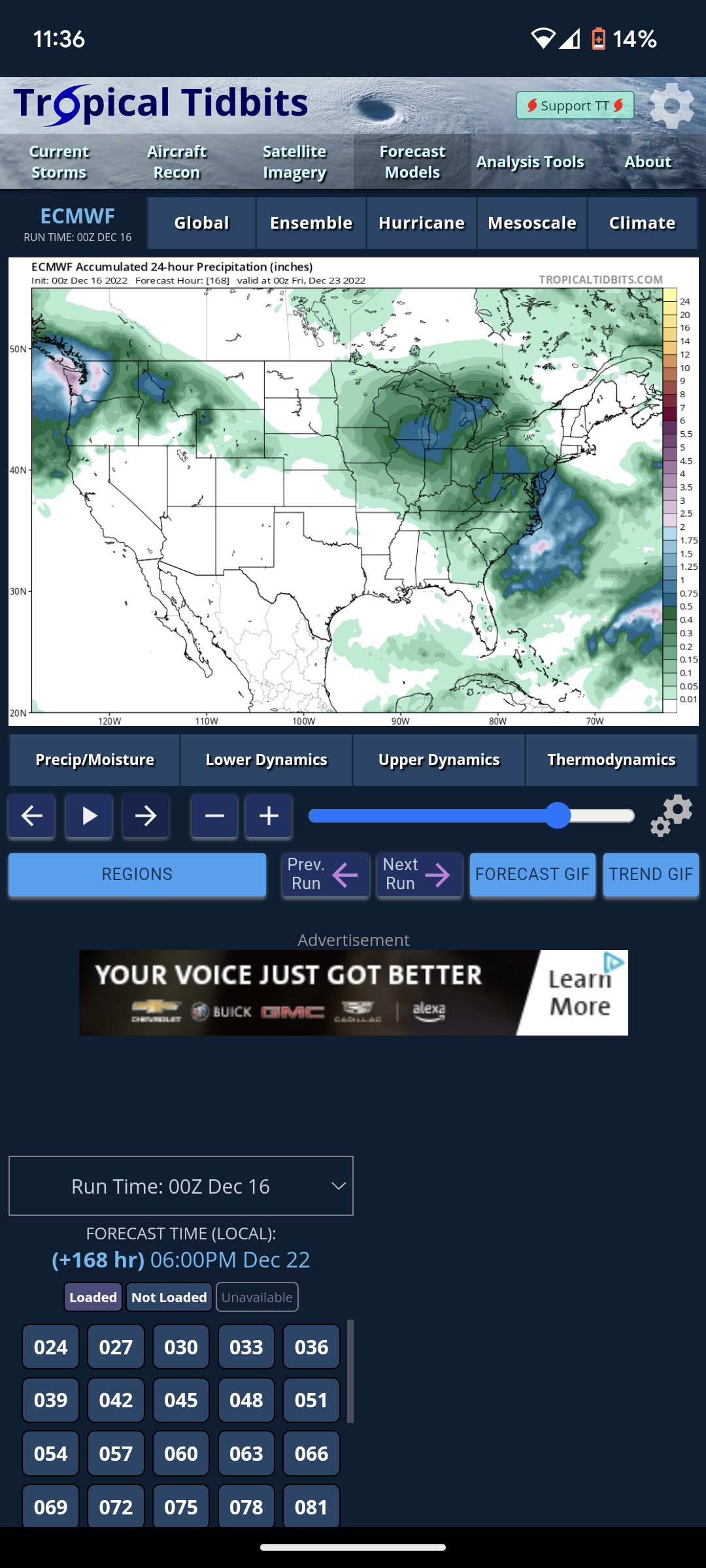
Pre-Christmas (Dec 21-23rd) Winter Storm
ChiTownSnow replied to Chicago Storm's topic in Lakes/Ohio Valley
And '79 -
Pre-Christmas (Dec 21-23rd) Winter Storm
ChiTownSnow replied to Chicago Storm's topic in Lakes/Ohio Valley
Wasn't GHD 2 showing a similar setup 4- 5 days out? but ultimately turned more of a west to east trajectory? -
Pre-Christmas (Dec 21-23rd) Winter Storm
ChiTownSnow replied to Chicago Storm's topic in Lakes/Ohio Valley
But It's also the ukie -
Pre-Christmas (Dec 21-23rd) Winter Storm
ChiTownSnow replied to Chicago Storm's topic in Lakes/Ohio Valley
Agreed. The risk here is that it doesn't bomb out until it's north east of here, giving upper Michigan the huge hit. But either way it's looking like a white Christmas and will be fun to watch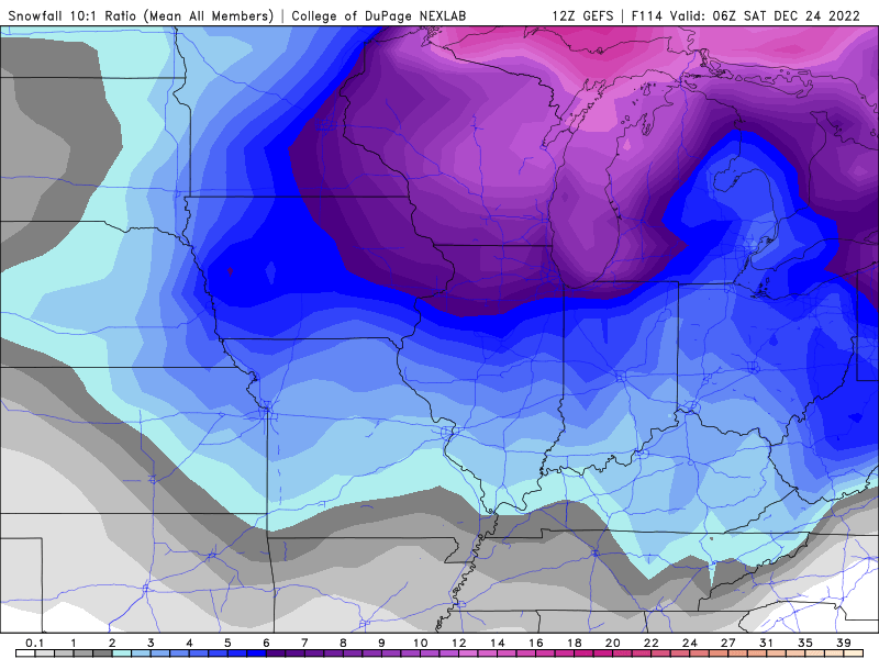
-
Pre-Christmas (Dec 21-23rd) Winter Storm
ChiTownSnow replied to Chicago Storm's topic in Lakes/Ohio Valley
Yes.. This is why applaud LOT's verbiage and deemphasizing amounts at this point. -
Pre-Christmas (Dec 21-23rd) Winter Storm
ChiTownSnow replied to Chicago Storm's topic in Lakes/Ohio Valley
Sure does -
Pre-Christmas (Dec 21-23rd) Winter Storm
ChiTownSnow replied to Chicago Storm's topic in Lakes/Ohio Valley
Also weaker (thus far) Edit -. Not by much as it really wraps up -
Pre-Christmas (Dec 21-23rd) Winter Storm
ChiTownSnow replied to Chicago Storm's topic in Lakes/Ohio Valley
I will also add that the specific verbiage used now holds more weight, as over the last few years LOT has used their words very responsibly and carefully. -
Pre-Christmas (Dec 21-23rd) Winter Storm
ChiTownSnow replied to Chicago Storm's topic in Lakes/Ohio Valley
So look for the late Tuesday or Wednesday time frame. Given holiday maybe more late Tuesday? Assuming current guidance continues -
Pre-Christmas (Dec 21-23rd) Winter Storm
ChiTownSnow replied to Chicago Storm's topic in Lakes/Ohio Valley
Question.. given that it is around the holidays, when do you think winter storm watches would be hoisted? I would assume giving the situation, a bit earlier than normal? -
Pre-Christmas (Dec 21-23rd) Winter Storm
ChiTownSnow replied to Chicago Storm's topic in Lakes/Ohio Valley
I like the last paragraph..haha -
Pre-Christmas (Dec 21-23rd) Winter Storm
ChiTownSnow replied to Chicago Storm's topic in Lakes/Ohio Valley
Although track wise GFS has caved a bit to other models, this is NOT the same storm the EURO had a few runs ago. Just need to level set a bit -
Winter 2022/23 Medium/Long Range Discussion
ChiTownSnow replied to Chicago Storm's topic in Lakes/Ohio Valley
I'll take it
-
Winter 2022/23 Medium/Long Range Discussion
ChiTownSnow replied to Chicago Storm's topic in Lakes/Ohio Valley
The end of the NAM run looks interesting for early next week.. But it's also the end of the NAM run -
Winter 2022/23 Medium/Long Range Discussion
ChiTownSnow replied to Chicago Storm's topic in Lakes/Ohio Valley
GFS = baby steps in right direction -
Winter 2022/23 Medium/Long Range Discussion
ChiTownSnow replied to Chicago Storm's topic in Lakes/Ohio Valley
Per GFS, the 20th is looking more and more interesting -
Nice consolation prize snow showers going on imby
-
Winter 2022/23 Medium/Long Range Discussion
ChiTownSnow replied to Chicago Storm's topic in Lakes/Ohio Valley
Let's also see what happens with the 19th-20th . Once that becomes clearer may help sort everything out -
Winter 2022/23 Medium/Long Range Discussion
ChiTownSnow replied to Chicago Storm's topic in Lakes/Ohio Valley
Call me crazy I guess, but I actually think it's a step in the right direction over the last few GFS runs. Especially given what we just saw with the most recent storm, If you assume that the GFS is too aggressive and fast with the Arctic front, then everything pulls back west again -
Winter 2022/23 Medium/Long Range Discussion
ChiTownSnow replied to Chicago Storm's topic in Lakes/Ohio Valley
Tough crowd in here... Sheesh -
Winter 2022/23 Medium/Long Range Discussion
ChiTownSnow replied to Chicago Storm's topic in Lakes/Ohio Valley
GFS Arctic front is more of a poke than a slap. -
Winter 2022/23 Medium/Long Range Discussion
ChiTownSnow replied to Chicago Storm's topic in Lakes/Ohio Valley
I think the models are too fast/aggressive with the Arctic front, both in timing/speed, and strength which is creating havoc with the opperational models in spinning up a storm If everything slows down a bit (which I think it will) then the Christmas week storm will come back again again in some fashion -
Winter 2022/23 Short/Medium Range Discussion
ChiTownSnow replied to Chicago Storm's topic in Lakes/Ohio Valley
It's the new age.. Where facts don't matter. -
Winter 2022/23 Medium/Long Range Discussion
ChiTownSnow replied to Chicago Storm's topic in Lakes/Ohio Valley
New drinking game.. Every time someone mentions "CAD" this year...sheesh. -
Winter 2022/23 Medium/Long Range Discussion
ChiTownSnow replied to Chicago Storm's topic in Lakes/Ohio Valley
I'm not saying I do, or it will be. I'm saying I'd rather have the model show that this far and have it back off a bit vs showing confluence setting up around I-80 as ND the we n hope it pushes further