.jpeg.fb71a75fc71475b59e72598d4a9a6f88.jpeg)
TJW014
-
Posts
1,074 -
Joined
-
Last visited
About TJW014

- Birthday 10/14/2001
Recent Profile Visitors
5,466 profile views


-
2 weeks till 7 PM sunsets
-
Erosion from most of the shore is pretty cyclical. Some erosion during the cold months, then the beach rebuilds in the summer when the waters are calmer. Aside from the October Nor'easters and obviously our blizzard on Sunday/Monday (which I didn't notice any further erosion from, and come to another theory of mine) the waters have been relatively quiet What I have observed is a near constant stream of small, long period (12-14s) swell almost due south all winter. That longshore current combined with the the heavy offshore winds this season make me think a lot of this sand is going north and/or is being stored in the offshore sandbars. I really want to get some bathymetry data adjacent from this site specifically, since the sandbar at least from a standing perspective seems much farther offshore. I'm going to build a sonar rig to mount on either a paddle board or kayak using a Garmin unit that will data log bathymetry. Just a matter of me finding a day that's pretty flat and being willing to throw the wetsuit on and paddling I like building and using my own equipment, that way I'm not tied to anybody and it gets done the way I intended it. But yes, to answer you, I plan on monitoring this for a few years on a monthly basis.
-
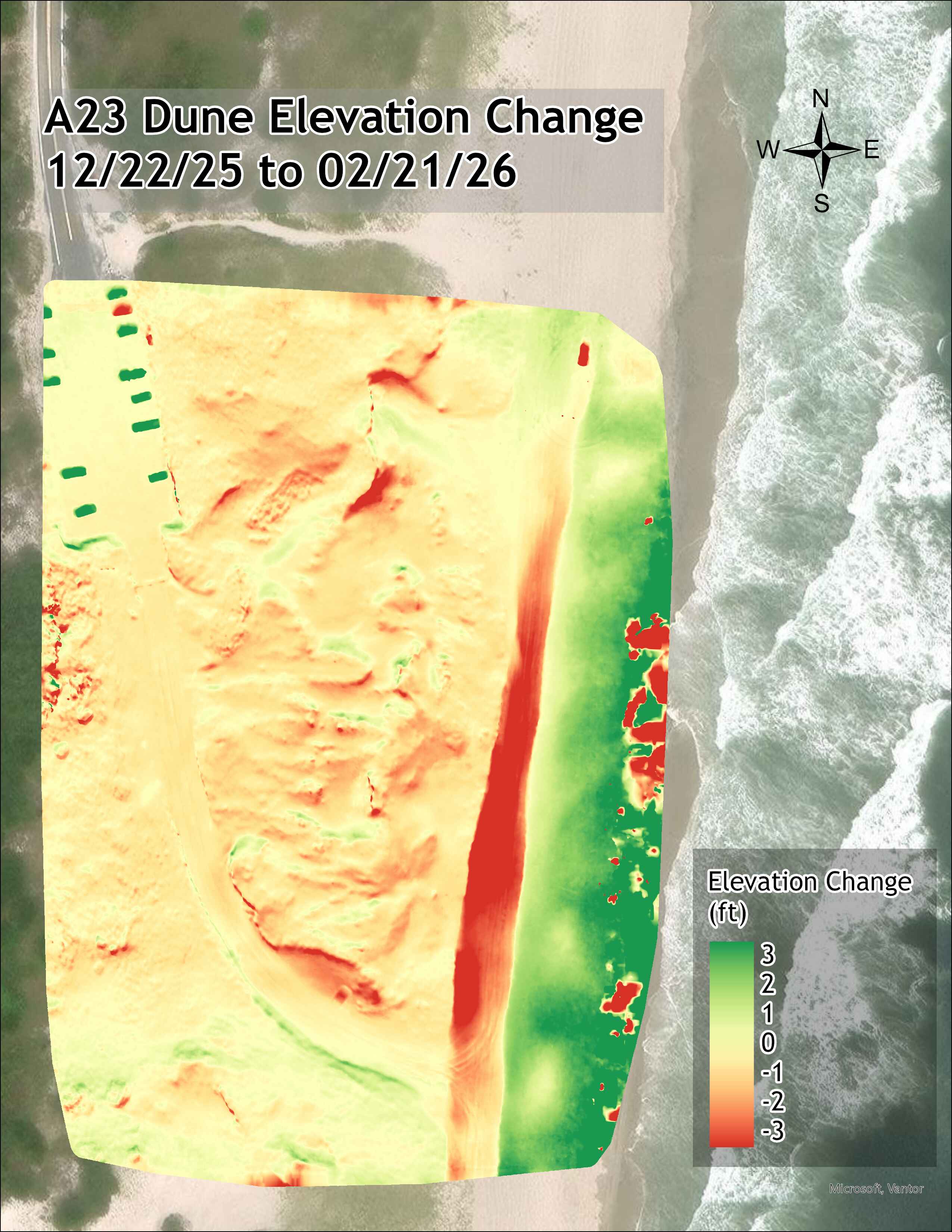
Maybe interesting, maybe not interesting, but I love visualizing data. And I'm dabbling in some GIS too. Been monitoring a section of beach that's seen erosion for years now, yet there's been no effort to restore anything. No more Christmas tree drop offs or even simple snow fence to catch any sand. I've even offered to bring my own posts and fencing. Anyway here's a 2 month elevation change. Note the scarping on the dune front, and the added elevation in front. The red blotches on the far right are noise from light reflecting off the water. In total (and excluding the outliers) 1400 cu. yds of sand lost in a 4 acre plot of beach

-
2.0" in 30 min
-
Heavier snow from this weenie clipper band than anything from Sunday/Monday. Easily an inch so far in 15 min
-
Sun angle doing its thing one the plow goes by. Didn't even salt. Finished with 22.5" biggest snow in 16 years here.
-
11:45. 19". Last ripper of a band pivoting in. Need to get to 24.5" to secure the bet.
-
I thought I was just measuring in a bad spot but went around for 15 minutes with the yardstick. Local measurements nearby are in the 12-14" range here too.
-
Freehold is gonna hit 30". Already at 24.2" there. But 5 days ago Steve D said there was no storm threat.
-
Got the snowshoes out and made a path to my measuring spot in the open field. 12.5" average as of 8 AM. Do we make it to 20"? Not so sure anymore.
-
Successfully napped off the migraine. There's easily another 3-4" on the roofs of the cars in the yard. Big 2' drift in between them. Peak gust of 52 mph. Still have yet to see a crusher of a band on top of me. Think the only thing saving the snow total are the higher ratios. This new stuff I can't pack into a snowball. I'd guess 15:1?
-
Could've played a part too lol. Classic migraine symptoms on my end. Runs in the family and my brother has one too. A migraine pill and I'll nap it off for a couple hours.
-
Ocean County has been kinda screwed over with the banding over the last couple hours.
-
About 8.5-10” in the yard after poking around for a bit. Then again I have drifts of 18” and spots that have bare ground from the blowing snow. Luckily with the wind direction, the driveway seems to be a wind tunnel blowing the snow right out and down the street. Less shoveling for me. Negatives? The rapid pressure drop has given me a migraine
-
Need to see some yellow.
.thumb.jpeg.f5c6ba9d911ec96b3b124f8606aee58e.jpeg)